Landair Surveying News

BIM-Se

3d Laser Mapping: Using Technology to Gain Accurate Measurements

3d-laser-mappingIf you have recently considered using a survey company or are currently aligning with one, the term 3d laser mapping might have been mentioned. This process involves the use of a 3d laser scanner when surveying a structure or environment to capture extensive points of data about the area in a short amount of time. The scanner uses laser light technology to capture the data at a faster rate. 3d laser mapping offers greater efficiency over the traditional approach of visiting the building each time to take a measurement to know the actual dimensions.

As opposed to traditional methods, 3d laser mapping provides dependable, accurate measurements in less time. A scan offers all the necessary data in the form of a digital record for easy collaboration and fast access. For example, if you need to know the number of light fixtures within a structure, all you have to do is look at 3d laser mapping data. If additional members of your team need to see this information all you have to do is share the point cloud created during the scan. 3d laser mapping provides a faster, easier way to obtain accurate information for any area by using advanced technology to collect and store it in a digital format.

How Does The Technology Work and What Are the Benefits?
A 3d scanner rotates in a circle to capture the data regarding everything it sees within the mapping area. Similar to the workings of a camera, they may be set up rather quickly to do multiple scans of a structure or area. Every scan involves collecting a vast number of data points, which are combined to deliver a digital image of the surveyed site, building, or area. 3d laser mapping is used to capture a buildings current state including every nuance.

This technology is used to analyze any object or location to collect specific data regarding its shape or appearance. The information is then utilized to render 3d models for these among other areas:

  • Surveying
  • Building Construction
  • Industrial Design
  • Reverse Engineering
  • Prototyping
  • Quality Control

Most 3d laser mapping services will use varying tools depending on the type of scanning to be performed. In the end, more than one scan is performed to gain as much data as possible for accurate mapping and modeling. There are several benefits to using 3d laser mapping over traditional methods, but these are the most notable:

  • Reduced Time
  • Increased Accuracy
  • Process is Non-Intrusive
  • Information Stored Digitally

3d laser mapping allows you to have the answers to unknown questions before they even become apparent thus allowing for faster workflow. It provides an opportunity to optimize scheduling while at the same time keeping shutdown measures at a minimum. Use of 3d technology reduces errors, decreases the number of change orders, and limits waste. Since the measurements do not have to be taken by hand during multiple visits, the risk of injury is much less and this boosts safety for every involved party. At LandAir Surveying, we use 3d laser mapping to provide an accurate depiction of structures and environments to ensure the right information is gained for achieving your surveying and decision-making objectives. Contact us today!

BIM-Construction-Professionals

How Do Construction Professionals Use BIM?

BIM (Building Information Modeling) is a three-dimensional technology that combines the use of intelligent information with the modeling process to deliver accurate representations prior to, during, or post construction. It helps service providers to align objectives, as analysis, planning, and building take place. BIM offers advantages from the initial stages of planning including land surveying to gain detailed location information to analyze the property during construction planning. It also provides great insight for detecting interference and avoiding errors because providers are able to:

  • Communicate Better
  • Visualize the Process
  • Improve Layout Dimensioning
  • Use Progress Simulations
  • Maintain Lower Costs
  • Coordinate Involved Parties

BIM-ConstructionLarge projects flow better because the process delivers improved coordination between multiple teams ranging from design to operators. When combined with additional intelligence, providers are able to deliver enhanced results throughout the full life cycle of a property at a lower cost.

It creates a virtual design forum where each party can contribute information and detect issues from a simulated structure prior to ever breaking ground. This model is created by the design team and then provided to every contractor, owner, or operator. These individuals then add their own data to the shared model for complete accuracy and enhanced communication. With BIM, every stakeholder is able to view the information thus ensuring there are no scheduling clashes or design issues. BIM makes it easier to identify the problems early on so they are addressed within the simulated structure rather than the physical structure.

BIM Benefits Everyone
Information gathering starts during the initial land surveying to aid in the planning and analysis before design takes place. BIM offers great insight for assessing the physical characteristics of a property. This information is automatically included into the model as each party contributes additional data regarding components, processes, and design characteristics. The data may then be mined to identify project performance or any existing problems as well as to monitor the construction process as it takes place.

The technology is not limited to construction as it is applicable when designing or displaying the functional characteristics of a facility. To keep it simple, BIM is a digital representation for viewing the characteristics of a piece of property, project, or existing building. Three-dimensional modeling is applicable for these construction phases:

  • Surveying
  • Planning
  • Analysis
  • Design
  • Building
  • Operations

At the technical core, it delivers improved information management through the use of intelligent models; however, it also boosts project coordination and collaboration between each player. It is a better approach than each involved party obtaining information from another provider who is higher on the chain for completing a project thus creating gaps in the process.

BIM provides a dependable, collaborative environment where 3D models may be used to input data and coordinate every portion of the construction process from one central database of information. Now each contributor has access to accurate information combined with accurate simulations for better analysis and decision-making as a project progresses. At LandAir Surveying, we use 3D technology to provide our clients with a better understanding of a location’s physical properties to ensure the proper path for project success. Contact us today to learn more!

High Definition Surveying: What Is It?

HighDefinition SurveyingHigh Definition Surveying (HDS) or 3D Laser Scanning is a now an industry standard for small or large development projects. Several technology advancements have made this approach one of the best ways to keep a project moving smoothly and costs low. This is because high definition surveying helps managers gain precision data faster for incorporation into the modeling process. With this approach, a narrowed beam consisting of pulsed laser light is deployed across the target area to record an extensive amount of measurements at the same time.

The measurements are then shown on a computer screen in what is called a point cloud. It is similar to a three-dimensional model; however, the scan locations are actually combined into the point cloud for use in various types of design and development services. Point clouds are used in these among other endeavors:

  • Virtual Walkthroughs
  • Detecting Interference
  • Containment Analysis
  • Building of 3D Interactive Models
  • Demolition or Critical Move Plans
  • Inventory Management

High definition surveying delivers a non-intrusive method of rapidly collecting data about a location. This type of surveying is applicable in a number of areas ranging from construction to design planning. It delivers accurate, economical details about a location or structure with an advanced level of detail over alternative surveying methods. The created models may easily be viewed and modified on a computer. This allows the data to be incorporated into other modeling technologies used in this field for improved analysis and design.

What Advantages Does High Definition Surveying Offer?
Many advantages may be gained from using high definition surveying as the collected data ensures fast analysis as well as application during computer-aided design or building information modeling. Among these benefits is the ability to visualize the area to determine where building should take place and identify safety concerns. For example, having a model of a terrain aids in determining the best location for a structure without the need for alterations. This allows all involved parties to make decisions faster and with far more accuracy.

The primary benefits of HDS are faster data collection with exceptional accuracy for reliable analysis and modeling. HDS makes it easier to collect the information with less effort as a two person crew is able to scan as much as ten acres in one day whereas conventional methods require a larger crew and cover less acreage. By using HDS, the costs of a survey are significantly lower for any sized project. The surveying process aids in several design and building project areas including the development of:

  • Site or Floor Plans
  • Building Information Models
  • Digital Terrain Models
  • Foundation Plans
  • Electrical Plant Layouts
  • Space & Asset Inventories
  • Structural Plans

High definition surveying reduces need for further site visits because the scan is performed once for data input. It is not necessary to return to the site to take further measurements. The technology offers a low cost, reliable approach to change detection, hazard surveying, accident reconstruction, as-built assessments, and construction projects. At LandAir Surveying, we use HDS to deliver accurate, fast terrain data. Contact us to learn how high definition surveying may be used to ensure the success of your latest development project.

Building-Mapping

What Is The Purpose Behind Building Mapping?

Building mapping is a type of survey performed by professionals to identify the location of each constructed element of a structure to gain measurements or produce plans. These processes are typically required prior to renovating a building or at some point during construction. Building mapping technology captures the current state of a building or facility. In some cases, it is an applicable approach to modeling an entire city in order to recreate it in a computer-generated model. This is beneficial for evaluating a cities current topography for renovations and has even been used to generate locations in video games based off a real place.

Building mapping involves gathering precise measurements to display an accurate projection of its internal or external structure. One example of this would be the creation of a floor plan based on the existing state of a building to display fixtures, pipes, doors, windows, and dimensions. The process is frequently used to survey a property and generate a floor plan or model for:

  • Upcoming Renovations
  • Historical Preservation
  • Surveying Older Buildings
  • Unconventional Construction Projects
  • Structural Changes
  • Post Renovation or Construction asbuilts documents

Traditional methods involve the surveyor taking a physical walkthrough of the property to gain measurements and map it out. However, new technologies such as three-dimensional scanning and modeling have made this process not only easier, but also far more reliable. These technologies provide faster results by automatically collecting essential data for building information modeling or computer-aided design to provide an accurate structure model for managing the project.

Why is Building Mapping Important?
Building mapping provides pertinent data for anyone who wants to make changes or needs to map out routes to support emergency planning. For example, if you want to renovate a building, knowing the location of piping within the structure ensures nothing is busted or harmed during the change. It also helps builders determine where fixtures should go or new supported piping should be placed. The same applies to electrical changes, room additions, and assessing the progress of a structure as it is built.

A combination of physical surveying and scanning technology is often used to gather information about a structure based on mathematics and dimensions. This information is then applied within a specialized computer application to generate:

  • Evacuation Maps
  • School Security Maps
  • Interactive Structure Information
  • Renovation Plans
  • Campus Maps
  • Floor Plans
  • Piping or Fixture Layouts
  • Structure Age or Sizing Measurements

Building mapping is a beneficial process when you want to acquire data to input into 3D modeling programs. Several methods are applicable for acquiring this data including Building Information Modeling or BMI. 3D laser scanning is often used to acquire the data needed for BMI, which may then be built upon throughout the renovation or construction process to avoid errors or setbacks and maintain costs. Additionally, it allows companies to identify any existing safety hazards to eliminate the chance of injury within a structure. At LandAir Surveying, we use the latest technology to complete building mapping. Whether it is an old building, an unconventional structure, or you simply need a floor plan, we can help you identify every aspect of the building for guaranteed project success.

Benefits of BIM for Surveying, Design, and Construction

Historic renovation Plant to Hotel from LandAir Surveying on Vimeo.

BIM or Building Information Modeling involves the generation of 3D digital representations of the physical or functional characteristics for an existing enviroment. BIM technology allows designers to easily collaborate during the decision making process of a building process. The information is beneficial to many design professionals involved collectively in the same project.

  • Planning
  • Design
  • Construction
  • Operation
  • Maintenance

A number of highly diverse infrastructures frequently use BIM including wastewater management facilities, electrical plants, oil & gas facilities, communication utilities, roads, bridges, houses, and schools. BIM helps those in the field of construction envision a project before it is started to eliminate uncertainty, work out problems prior to building, and analyze potential risks.

How Does BIM Help?
BIM is an alternative option to the traditional Computer-Aided Design (CAD) strategies because it offers a number of advantages over traditional methods such as the ability to graphically show information for design and development andit is easily distributable to many different team members collectively. To truly understand the difference, the first thing to remember is that BIM is not simply a technology, but rather a process used to support the design, construction, or management of a design or renovation project.

The technology itself is available on several different platforms, which support both architectural tools and incorporate information intelligence as part of the modeling process. BIM often consists of several layers spanning these areas:

  • Model & Object Creation
  • 3D Asbuilt information of existing conditions
  • 3D Models of esisting and proposed enviroments
  • Ability to clash the new design with the old to identify difficult areas

Each level of implementation provides the ability to share information between individuals for improved planning and development. Three-dimensional, dynamic modeling is used to boost productivity as well as have a better understanding of these items: building geometry, spatial relationships, component properties and geographical data. This approach to 3D modeling delivers several benefits for achieving a solid design for the complete building data lifecycle.

What Are The Advantages?
BIM is more than just a modeling process, providers are able to use gathered information to make intelligence driven decisions throughout every phase of development. This prevents the need for rework, as the physical structures are implemented onsite. Additionally, this aids in limiting the number of conflicts or changes that arise during actual building or implementation thus decreasing costs. The benefits of BIM go beyond simple modeling to include:

  • Better Visualization
  • Heightened Productivity
  • Improved Document Coordination
  • Information Linking Between Contributors
  • Faster Delivery Time
  • Lower Costs
  • Shortened Approval Cycles
  • Reduced Project Duration
  • Predictability & Better Control

At LandAir Surveying, we have been providing high quality services for more than forty years. This includes vast experience in areas such as 3D laser scanning. We will help you gain a complete view of your property by using three-dimensional technology to boost the intelligence offered by BIM.

Five BIM Predictions in 2015

Building information modeling has become an integral part of the way many construction firms do business. More and more contractors are seeing the benefits and value of BIM and using it to take a more proactive approach to construction.

Here are some of the exciting things happening in BIM you should expect to see throughout 2015 and beyond…

1. BIM is Here to Stay

Today, virtually every large construction firm has a BIM department in-house and even most medium-sized firms either have BIM departments or are in the process of getting one. This trend will continue this year.

New software has made it easier for field teams to extract information from the field and drop it into 3D models to accurately reflect real-world conditions. The result is more accurate models and a more efficient process with less rework overall.

“Once all of the big construction firms are using BIM, all of the mid-tier firms will start using it. The big architectural firms already use it so the smaller firms who want to work with them will also have to have it,” said Tate Jones, owner of LandAir Surveying Company, one of Atlanta’s top five surveying companies. “That migration will continue – similar to the migration from hand drawings to CAD. In five years, there will be very few firms who don’t use BIM.”

For most, the first step in BIM adoption is model coordination. As a next step, firms will extend BIM to include laser scanning before and during construction, as well as total station layout during construction.

Read the full article here in Leica Geosystem’s BIM Learning Center…

Company Culture: Buy-in is a BIG part of your early success!

Is a laser scan right for your next project? Before you jump in with this revolutionary technology, ask yourself these five critical questions:

#1: How will you use the data? This is always the first question we ask our clients. Talk it over with your provider and/or specifically state how you plan to use the data in the RFP.

#2: What software and version will you use? A point cloud processed in 2014 will not work well with 2012 software. More importantly, your CAD production may be only 20% of the potential.

#3: What exactly are your deliverables? Be specific when talking with your provider about what your expected deliverables are, whether registered point cloud 3D photography, color point cloud, black & white, a CAD-ready model, or a video fly-through of the site.

#4: What is your expected level of capture detail (expressed in inches)? For example, do you need to capture everything 2-inches or larger or 1-inch and larger? The difference in these two can be 4x the work effort! Give this a lot of thought and discussion.

#5: What coordinate system do you want to use? This can be very important, as you may have existing plans or CAD files. If the point cloud and plans are on the same system, they will align perfectly. This is also true with project elevations.

Once you have decided laser scanning is right for your project, the next step is getting buy-in from everyone in the company who will use this data. Don’t overlook this step because buy-in is key to your early success!

Be aware: there is a learning curve to using laser scans and point cloud data, but studies have shown that companies that make the transition from the old technology (two guys and a measuring tape and grid pad) to high speed data capture with precision and clarity are ultimately much more efficient.

To realize the full benefits, you will need a “champion” in upper management and a good CAD technician who genuinely loves the technology.

Plan a training budget and send your team to SPAR or similar 3D conferences. It will foster buy-in, change your workflow and increase your productivity (and profit) in the long run.

###

Tate Jones has over 40 years of experience in land and aerial surveying and was one of the country’s earliest adopters of 3D laser scanning technology. A nationally recognized expert in the field of 3D data capture, he has worked with hundreds of clients in the engineering, architectural and construction industries. Contact him at tjones@lasurveying.com or visit www.landairsurveying.com.

The field scanning process: How to get the best results

Once your laser scan has been ordered, there are some things you can do to prepare for our crews.

First, prior to the scan, have someone (preferably a knowledgeable project manager) onsite to communicate with the scan team when they arrive.

Make sure your plant managers know crews are coming. If there is a local safety course that needs to completed or specific plant instructions, let them know upfront. Also let crews know if there is special gear they may need like moon suits, hairnets, safety glasses or ear protection.

The project walk-through is a very valuable process because this is where we determine the location of the scanner setups. Let crews know what is most important and what is less important. If a major conduit with fiber optics, a power transmission conduit, or particular piece of machinery is important to your project, for example, it is important to let the scanning crew know.

Also make sure the scanning crew has a contact that they can call if they have questions or need clarification mid-scan.

Crews will place targets around the scan area to tie all of the scans together and will remove them upon completion of the site visit. Once they understand the limits and the prime areas of interest, the scanning process will begin.

Though it is great to watch them work, these teams are professional and the less direction they have, the better the results! A typical job can take two days to several weeks. Each night, scanned data for the day will be checked to make sure there are no gaps or geometric issues with the data.

For black and white scan data, the process is simply this: scan, move to a new location, scan, move to a new location, etc. For color data, a set of photographs is added to the process: scan, remove the scanner, add a camera, take seven photographs (six at 60-degrees horizontally, one straight up), move the scanner, take photos at the new location, replace the camera with the scanner, scan, and repeat this sequence throughout the site.

This allows our crews to produce high-quality TrueView files. When they get into a rhythm, the above sequence maximizes efficiency up to 100%.

Post Processing

When the scan data comes back into the office, data is exported from the crew’s field laptop to the desktop. On large jobs, this will take several hours.

Next, if there are color photos, the color photo data is downloaded and registered to the point cloud. This process can take 5-10 minutes per set up. Around 100 set-ups can take 15 hours of technician time. (If there is only black & white data, we skip this step.)

Once the photo data is added to the raw data, the target information is then added to the data set. The data is then run through the final registration process. This program compares the data set to all the other common data sets and produces the final registered point cloud.

The point cloud is then tested visually and geometrically to make sure there are no errors. This is done by cutting it like a wedding cake to see that all of the horizontal surfaces line up and also looking at elevation views and pipe runs to make sure that these are consistent throughout the cloud.

After these are tested, the final registered point cloud is ready to be used. Files are then loaded on to a hard drive and shipped to you, the customer!

Now that you have the point cloud data, what do you do with it?

Registered point cloud data can be exported into AutoCAD, MicroStation, Bentley, Revit, Autodesk Recap and many other computer programs. Designers can then take this data and design and model it in a 3D environment.

A TrueView map of the site showing 3D spherical data in black & white or color can be created. You can measure between points in the point cloud with this free program.

Warning: We always recommend that for precise measurements, you use the point cloud information and not TrueView. The angle of the view can affect the measured distance in TrueView. At a minimum, check the measurement from several different views.

Computer models can also be built in Revit, AutoCAD or MicroStation and delivered to the client. These models can be imported into the point cloud and then “clashed” to see if the new model interferes with the existing point cloud.

Want to learn more? Contact us today to learn if a laser scan is right for your next project.

###

Tate Jones has over 40 years of experience in land and aerial surveying and was one of the country’s earliest adopters of 3D laser scanning technology. A nationally recognized expert in the field of 3D data capture, he has worked with hundreds of clients in the engineering, architectural and construction industries. Contact him at tjones@lasurveying.com or visit www.landairsurveying.com.

Getting a good estimate on laser scanning: What you need to know

When it comes to getting an accurate estimate on laser scanning services, it’s all in the details. The more detailed information you can provide vendors upfront, the more accurate your estimate will be.

What kind of information do vendors need?

Floor plans of the site and photographs. This will go a long way in getting vendors the information they need to provide you with an accurate estimate rather than just a “high guess” because they’re not sure what they are scanning.

“Character” photographs. These photographs can show a few strategic shots, which are better than simply saying, “It’s an MEP room,” (though it’s really 40-feet tall). If possible, show examples of density.

Video walk-through of the site with a smart phone, complete with narration. This is extremely valuable to vendors to get a clear idea of the scope of the project.

Accurate information on the site and work conditions. This includes extenuating circumstances such as crews only being able to work between 11:00 PM and 5:00 AM, heavy factory work around the clock, extreme temperatures, mandatory safety training, difficult travel conditions (ex: 200 miles from the airport in “Nowhere, USA”), travel expenses not included in estimate, or dangerous site conditions like confined space entry that require special training.

For the best and most accurate price, be upfront and give providers a good idea of what they are getting into, including:

  • Travel to and from site. Include air travel, luggage, rental car, hotel and location.
  • Time on site. This is determined by how long it takes to begin work once crews get to the front gate and the available work hours. (Is it 4-6 hours max or 12 hours?)
  • Work conditions. High-density projects take longer. Lots of vibration slows down the scanning process.
  • Highly reflective material is very difficult to scan (ex: mirror glass, chrome pipes, shiny objects).
  • Heavy foot traffic (mall), loading traffic (fork lifts), or plant process (moving machinery) can complicate the project.
  • Dangerous conditions usually slow scanning, but crews can still perform and scan in sub-surface pipes or tunnels, interstate bridges and heavy construction zones.
  • Night work only always takes longer and increases the difficulty.

Other pricing considerations include the expected deliverables from the job and the level of detail you need, which software package you want data delivered in (some are faster than others), how complex the environment and large the site, and if additional trips are required back to the site.

Remember: though scanning may only take a week or less, modeling can take a month, as it is still not automated.

Most scan projects are too big to e-mail, so you can expect to receive the full deliverable on an external hard drive. Raw point cloud data can reach “gigabyte size,” though finished models and 3D data sets are typically much smaller.

###

Tate Jones has over 40 years of experience in land and aerial surveying and was one of the country’s earliest adopters of 3D laser scanning technology. A nationally recognized expert in the field of 3D data capture, he has worked with hundreds of clients in the engineering, architectural and construction industries. Contact him at tjones@lasurveying.com or visit www.landairsurveying.com.

Our 25 Hours in Haiti

The alarm was set for 4:00 AM. It was going to be a long day.

The mission was to travel to Haiti to survey space for a new community kitchen. The existing kitchen feeds some 1,400 children each day their only meal, which most days is no more than beans and rice. They are the lucky ones. Many children in the area receive only “mud cookies,” which is exactly what you are imagining.

Several Atlanta-area churches joined together to build a new, bigger kitchen in Port au Prince that can feed as many as 10,000 people. They enlisted the help of LandAir Surveying and Paul Gresham, an architect who works with Chick-fil-a and a member of one of the involved churches, to create a base map for the master construction plan.

I made the trip to Haiti with Allen Nobles, president of Nobles Consulting Group in Tallahassee, Florida. We have been friends for many years and have worked together on projects all over the country – but nothing quite like this.

The plan was to scan the entire site consisting of an existing one-story school, an old building housing the existing kitchen, the future kitchen site, and a church and the campus walls around it. The existing kitchen has no running water and the sewer system is merely a pipe that goes through the wall to a creek out back. By Haitian standards, this is state of the art.

To further complicate matters, this is a particularly scary part of Port au Prince with a high crime rate. People are poor. Tourists have been kidnapped. Dysentery, yellow fever, malaria and cholera plague the area and the roads are full of potholes.

As we made our way through back roads crowded with cars and children, we finally arrived at the front gate of the school where the new kitchen will be built. Our van pulled into the tight driveway and the driver blew his horn, a sign for the guards to open the gate.

Once inside, we joined Paul, Pastor Vincent – the school’s headmaster – and a local architect assigned to help with the project.
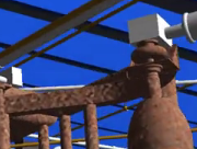
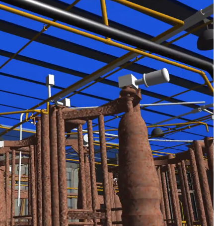
Preparing to scan

Paul provided a general idea of what he needed for the design team. The school’s campus consists of a single story school building approximately 300-feet long divided into 10 classrooms. On one side of the campus is a large church that also serves as a meeting room.

In the center of the campus is a large building that is to be demolished. It houses a kitchen that is approximately 20-feet by 25-feet. The cooking equipment consists of some large bowls and pans used for both cooking and washing the dishes. The stove is simply six propane burners. This small kitchen serves 1,400 meals a day to the students and local children.

The goal was to produce a map of the campus and get enough information on the existing school so that a second floor could be added. Paul and his design team would prepare a master plan for future development, but their top priority was building a very large and modern kitchen capable of feeding 10,000 people daily.

When we decided to go on this trip, we knew we didn’t have a lot of time, so we built our equipment for lightness and mobility. It’s not easy to get all of the survey equipment you need into to backpacks and two small carry-on bags. You have to be creative and decide what you want, but take what you need.

Among that equipment was a Focus scanner and supporting equipment along with a small level, rulers, and a miniature tripod that folded up to 23-inches but expanded to about 65-inches. Allen also brought along some very handy paper targets with numbers and lead weights to hold them and a series of globes that cost around $5 each.

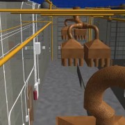
We had a two-minute project meeting with the architect and then taped-up 8-10 paper targets in the main area and started scanning with the Focus. Then we taped about 60 targets around the campus on the sides of the buildings, constantly moving the globes ahead of us and using the lead targets.

Once we had completed scanning the campus and buildings, we moved on to the roof.

View from the roof!

When you’re working inside the campus gates, you forget where you are. But when you are on the roof, it all comes back. Not 15-feet away, we could see a small alley filled with families and kids. Even though they were too poor to eat, they would look up at us and smile and laugh. They were very excited to see something different.

From the roof, there is also a clear view of the “river,” which is nothing more than the local sewer system run-off covered in garbage. Hogs, goats, and cows graze alongside it.

The trip also included a trek to New Life Children’s Home, an orphanage and oasis owned by a local woman named Miriam who had once found Pastor Vincent as a very small child, almost dead from starvation. She took him in and nurtured him back to health. He ended up going to college in Tennessee and returning to Haiti to start several schools and orphanages there.

The orphanage, which houses close to 100 children, has running water, bathrooms, electricity, clean bedrooms and many of the comforts of home. The electricity is run by generators and turned off at night to save energy.

After dinner, Paul asked us to look at a few of the buildings on campus to see if they could be scanned and documented. We did a quick assessment of what could be done given their tight timeframe and decided to scan one of the bigger, more complicated buildings first thing the next morning.

When all of the scans of the buildings and school were complete, Pastor Vince took us on a tour of the impoverished surrounding area known as Destiny Village.

I took a lot of pictures and some video on my iPhone, but after a while, you feel bad documenting the poverty surrounding you and realize how little they have, need or want.

What my household throws away in a week would feed two or three families.

Headed home

After clearing customs at the airport and heading back to Miami, Allen and I went our separate ways. But the 25 hours we spent in Haiti will stay with us forever.

I’m glad we were able to use scanning technology in Haiti as there is no better, faster or more precise way to document data. But the scanning was the easy part.

The hardest part was seeing how these people live and the difference between our lives and theirs. We know we can’t save all kids displaced by earthquakes, hurricanes, and dishonest dictators and government corruption in Haiti. But if the kitchen gets built and the kids get fed, we may have helped to save a few. That was worth 25 hours in Haiti.

Tate Jones and Allen Nobles have been friends in the surveying business since 2007. Tate is the president and owner of LandAir Surveying Company, based in Roswell, Georgia. Allen is president and owner of Nobles Consulting Group, based in Tallahassee, Florida. Together, they have worked on projects all over America and generally share resources and technical expertise. To learn more, visit www.landairsurveying.com and www.ncginc.com.
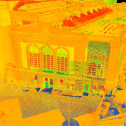
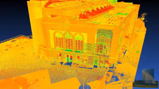