
3d Laser Mapping: Using Technology to Gain Accurate Measurements
 If you have recently considered using a survey company or are currently aligning with one, the term 3d laser mapping might have been mentioned. This process involves the use of a 3d laser scanner when surveying a structure or environment to capture extensive points of data about the area in a short amount of time. The scanner uses laser light technology to capture the data at a faster rate. 3d laser mapping offers greater efficiency over the traditional approach of visiting the building each time to take a measurement to know the actual dimensions.
As opposed to traditional methods, 3d laser mapping provides dependable, accurate measurements in less time. A scan offers all the necessary data in the form of a digital record for easy collaboration and fast access. For example, if you need to know the number of light fixtures within a structure, all you have to do is look at 3d laser mapping data. If additional members of your team need to see this information all you have to do is share the point cloud created during the scan. 3d laser mapping provides a faster, easier way to obtain accurate information for any area by using advanced technology to collect and store it in a digital format.
How Does The Technology Work and What Are the Benefits?
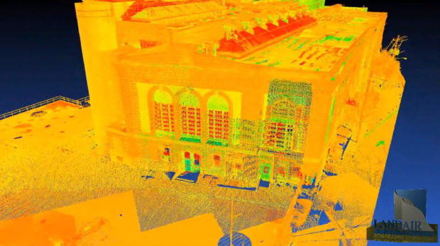
A 3d scanner rotates in a circle to capture the data regarding everything it sees within the mapping area. Similar to the workings of a camera, they may be set up rather quickly to do multiple scans of a structure or area. Every scan involves collecting a vast number of data points, which are combined to deliver a digital image of the surveyed site, building, or area. 3d laser mapping is used to capture a buildings current state including every nuance.
This technology is used to analyze any object or location to collect specific data regarding its shape or appearance. The information is then utilized to render 3d models for these among other areas:
- Surveying
- Building Construction
- Industrial Design
- Reverse Engineering
- Prototyping
- Quality Control
Most 3d laser mapping services will use varying tools depending on the type of scanning to be performed. In the end, more than one scan is performed to gain as much data as possible for accurate mapping and modeling. There are several benefits to using 3d laser mapping over traditional methods, but these are the most notable:
- Reduced Time
- Increased Accuracy
- Process is Non-Intrusive
- Information Stored Digitally
3d laser mapping allows you to have the answers to unknown questions before they even become apparent thus allowing for faster workflow. It provides an opportunity to optimize scheduling while at the same time keeping shutdown measures at a minimum. Use of 3d technology reduces errors, decreases the number of change orders, and limits waste. Since the measurements do not have to be taken by hand during multiple visits, the risk of injury is much less and this boosts safety for every involved party. At LandAir Surveying, we use 3d laser mapping to provide an accurate depiction of structures and environments to ensure the right information is gained for achieving your surveying and decision-making objectives. Contact us today!


Leave a Reply
Want to join the discussion?Feel free to contribute!