Posts

SPAR International 2013: An exciting year of industry insight

Once again, the annual SPAR International Conference, which was held at the Broadmoor in Colorado Springs this year, was an absolute “must see” event for anyone in the laser scanning, lidar or photogrammetric mapping industries.

From collecting data through alternative means like “crowdsourcing” to new programs that stream point cloud data into design files, SPAR provides insight into how our industry continues to evolve.

Check out my observations at this year’s conference in Professional Surveyor Magazine. Read more

BIM: Breakfast of Champions

Whenever my travel and work schedules allow, I try to attend the BIM Breakfasts at Georgia Tech.

Held once a month on the Georgia Tech campus, the breakfast brings together some of the best and brightest minds in the Atlanta area.

The February event featured speaker James Barrett, the national director of integrated building solutions for Turner Construction. Jim specializes in virtual design and construction/Building Information Modeling (BIM) technologies, lean processes, and integrated project delivery.

Put in layman’s terms, he is pushing BIM and virtual design tools to the limit. Under his leadership, Turner Construction has become one of the top BIM users in the world.

Jim does not push BIM just because it’s BIM. His idea is that his designers and contractors need to use the best tools available to help their company succeed and their clients get the best results. The BIM process and virtual design flows naturally from that core idea.

Turner also does not push one specific type of software, but instead teaches as many as 10 or 12 different packages that their best and brightest have become familiar with. As with any tool, Jim explains, no one tool will do everything.

Another point he made was this: when you roll out a new technology, don’t try to convince the world that it’s the best way to go. Instead, show it to the early adopters and let them prove that it works and that it’s the most efficient option. It will naturally make its way to other potential users.

For me, this point really hit home.

In 2005, we began using terrestrial lidar and 3D scanning technology. I have traveled to many firms in the southeast and tried to sell the benefits to the whole AEC community.

Initially, I had minimum success. It was early in the process and few of the established firms were interested at that time. However, I did find a few and slowly built a successful 3D laser scanning division that still thrives today.

These firms were the early adopters. Ironically, it was not always the young guys that were the most open to new ideas. Sometimes it was an older person who could see like I did where this technology was headed.

Now this technology is almost mainstream and is an integral part of the BIM process.

In his presentation, Jim pointed out that in New York City they have “view protection” and laser scans are used to document the view of the construction site.

In the BIM toolbox, when you identify a complicated project, laser scanning is a tool that you should certainly consider. The benefits and uses of laser scanning data are numerous and the risk of not using one and incurring additional costs down the road can be significant.

Another really good idea that Jim presented was that every year, they take a small percentage of their new hires and immerse them into what they call BIM University.

These people then become experts that the rest of the company can learn from. This gives every group in the company and geographic area internal experts that they can lean on to best implement the technologies of BIM. What a great idea!

They even started an intra-company communication site on their intranet so that users anywhere in the company can post a question. In minutes, experts throughout the company can provide insights and answers and have a forum to share their knowledge.

I believe this practice will continue to grow as companies see the value of tapping into the knowledge base they already have with their employees. What a great tool for a leader to build in their own company.

Jim’s presentation also touched on the other tools that help to automate the construction and design process like the ability to view augmented reality on iPads with the use of QR codes. At his firm, they work with public inspectors to load iPads with plans and drawings to make their process quicker and more efficient.

He also addressed the effect that 3D printing will have on the construction industry. Though it will not likely take the place of massive building material needs, it will fill a unique need when a limited number of items are needed in a quantity that can be met with industrial 3D printers, he said.

There will always be people who question whether we need BIM and virtual design and construction. I cannot completely understand why anyone in the AEC industry would still be asking this question, but I do understand that in some subsets, there is much more low-hanging fruit than in others and for these, early adoption is a no brainer.

The push for BIM and virtual design use and innovation is coming out of the construction industry as the large GC firms have pushed it further and further into their processes.

If you are in the Atlanta area and want to see and meet some of the best minds in BIM, I do recommend the Georgia Tech BIM Breakfast forum. Every time I go, I learn something.

###

Tate Jones has over 40 years of experience in land and aerial surveying and was one of the country’s earliest adopters of 3D laser scanning technology. A nationally recognized expert in the field of 3D data capture, he has worked with hundreds of clients in the engineering, architectural and construction industries. Contact him at tjones@lasurveying.com or visit www.landairsurveying.com.

3D Laser Scanning

Advances in 3D data capture are changing faster than ever. How can we help you in 2013?

First, let me say Happy New Year to all of our clients who have supported us for the past 25 years. We appreciate you and are honored that you choose LandAir Surveying to team with you on many interesting projects across America.

Over the past seven years of traveling down the road of 3D data capture and using multiple platforms for LiDAR data collection, we have seen this technology expand into almost every field of design, construction and manufacturing.

It has been fascinating to watch the world change from 2D plans to 3D data sets and models. And in the process, modeling is becoming cheaper, faster and easier.

Having attended international conferences and through speaking to groups across the country, we have seen and studied with interest what is going on in the U.S., Europe, Japan, India and Asia. The whole world of design and construction is making this shift!

Daily, we talk with firms both domestically and internationally about the diverse issues of 3D design and construction to equip us with the knowledge we need to be your trusted resource for new approaches to surveying projects.

For example, we have been producing surveys for the transportation industry since 1998. I can remember when we had to actually put our surveyors out in traffic (with approved safety measures, of course). Now, with our scanners, we can stay off the shoulder of the road and capture all the required data without putting anyone in harm’s way. This is standard practice now and, as an owner of a surveying company, very important to me personally.

Approaches to projects are changing not only in transportation, but across all industries.

Last year, we produced a 400-acre topographic map with 1-inch contours in very, very dense foliage. Just two years ago, we would have had to field survey this project. But by using a combination of aerial LiDAR and strategic surveying techniques, we were able to produce the job at 1/3 the cost of a traditional field run survey.

In 2013, we plan to expand our technology, using drones to capture data on specific projects. This is already being done across the country and the technology is moving from military grade and unaffordable to civilian grade and absolutely affordable.

So, how can we help you this year? For one, we can show you how surveying tools are changing and getting better. We can discuss with you when to use airborne LiDAR to document and produce data over a city, county or state.

We can show you when the conditions are right to use mobile LiDAR and put together a team to make your project successful.

We know when to use helicopter platforms for LiDAR over fixed wing aircraft, and we can show you how to model the inside of an existing building faster and more cost effectively than ever before.

We look forward to being a valuable resource for your firm and hope to continue working with you in 2013 and beyond. The design world is changing very fast and we are committed to changing right along with it.

Have a great and profitable 2013!

###

Tate Jones has over 40 years of experience in land and aerial surveying and was one of the country’s earliest adopters of 3D laser scanning technology. A nationally recognized expert in the field of 3D data capture, he has worked with hundreds of clients in the engineering, architectural and construction industries. Contact him at tjones@lasurveying.com or visit www.landairsurveying.com.

What’s all the fuss about high definition scanning?

When it comes to making precise measurements in complicated environments, high definition scanning – or 3D laser surveying, as it is sometimes called – is quickly making its way to the front of the line in a wide range of industries from engineering to historic preservation.

Engineers use laser scans to work with real-world conditions in complex industrial as-built and plant environments. Construction companies use them to gather precise data on site terrain and renovations, and architects use them to check proposed design models against existing conditions to fine-tune their designs.

Even insurance companies and law enforcement have gotten on board, utilizing the technology to recreate large-scale accident scenes.

Why is it better? For one, laser scans are incredibly precise. Images are created from a “point cloud” of millions of points that can be measured precisely including the distances and elevations between points. They are also versatile. The scans, when used with digital color photos, can produce survey-quality files, videos or even 3D animated computer models and are so intuitive that even a novice can understand the information.

Laser scans are also fast. In 2006, when we bought our first scanner, it took almost an hour to produce a full dome 360 degree scan. Now we can scan in 6-8 minutes. This allows us to take many more scans and capture more detail than we did before.

Scanning almost always pays for itself. It is cheaper in the long run because you can revisit the original scan multiple times from your computer desktop without having to revisit the project site. Also, because the technology is so precise, the need for construction reworks and expensive retrofitting is minimized or removed alltogether.

For firms thinking about getting involved with this technology, there are currently three ways to capture 3D data on large scale projects: Airborne LiDAR (Light Detection And Ranging), Mobile LiDAR, and Terrestrial Scanners, which all produce LiDAR data.

Typical projects for terrestrial scanners are large pipes and tunnels, manufacturing facilities, plant process facilities, airport conveyor systems, bridges, buildings, towers and construction projects. (Our firm focuses on terrestrial jobs, as most cannot be readily scanned from airplanes or cars.)

The cost of entry into this kind of scanning is generally between $150,000 to $250,000 for the first units and software. (Although less expensive scanners are now available, software packages can still be expensive and the cost of training should also be considered.)

Aerial platforms and Mobile Platforms start at $500,000 and go up to $5,000,000. These units are constantly being upgraded with newer and better digital sensors and data management enhancements. We currently work with service contractors on these types of jobs, which are typically focused on documenting civil infrastructure on a much larger scale than terrestrial scans.

Projects could include scanning 100 miles of road to prepare a pavement analysis, mapping 1,000 miles of rail line, or mapping the City of Atlanta and producing 3D models of all the buildings.

If the cost of these units seems intimidating, keep in mind that firms that have already invested in these technologies are often open to partnering opportunities with smaller firms.

Small scanning focuses on objects the size of a Volkswagen all the way down to the mechanical components inside of a watch. The applications in this field – commonly referred to as “reverse engineering” – include quality control of manufactured parts or data capture for a manufactured process. A typical project could be scanning an ornate stair rail so that an exact replica can be created from wood, metal or composite.

This scanning method is so precise that you could dissemble a toaster, rifle or carburetor, scan the parts, manufacture duplicates, and they would all work when re-assembled.

What can be scanned?

If it can be built, it can be scanned. There is virtually nothing built that cannot be duplicated and modeled with current scanning techniques.

In addition to the engineering, construction and manufacturing industries, this technology is also being used by insurance companies and law enforcement to reconstruct accident scenes – like when a highway bridge falls during rush-hour traffic or a multi-car pile-up – and even on Hollywood sets. There are companies that make their living scanning elaborate movie sets before and after they are constructed.

To give you an idea of the wide-ranging capabilities of this technology, in the last month, we have scanned a 120-foot pipe in Chicago, a 737 aircraft in Delaware, a luggage system in LaGuardia, and the interior of a peppermill in Virginia. This technology is everywhere!

###

Tate Jones has over 40 years of experience in land and aerial surveying and was one of the country’s earliest adopters of 3D laser scanning technology. A nationally recognized expert in the field of 3D data capture, he has worked with hundreds of clients in the engineering, architectural and construction industries. Contact him at tjones@3DLaserSurveys.com or visit www.3DLaserSurveys.com.

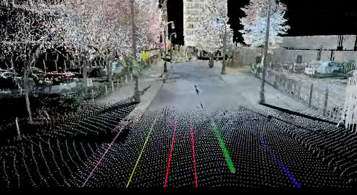
What can you do with a 3d Laser Scanner

What can you do with a 3d Laser Scanner that you cannot do with other types of surveying and mapping equipment?

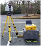
Scanner on 5” standard Tri Pod

Scanner on 5” standard Tri Pod

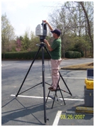
First let’s look back at where the 3D Laser Scanner came from.  Some people call it a Laser Scanner; Aerial mappers call it tripod scanning. I think it is more widely known as terrestrial scanning.  So laser scanning as I am talking about is all done on a tripod that is anywhere from 5’ tall to 15’ tall.  Most are moved around either on wheels attached to the tripod or by hand or now we even have truck mounts to improve speed.  As I said in my first article the uses’ for this technology are as varied as the imagination.  So what do they do that other survey and photographic equipment does not do.  Let’s look at what they do very well.  They collect very precise points in space and a very high rate of speed and the photography gives the laser  the ability to color these points.  This seems like a simple thing and one could wonder why it is such a big break through.  Because these points are precise one is able to go scan and object and then reproduce that same object in a computer.  Not only reproduce the dots but reproduce almost every feature that comprises that object.

3DLaser Scanner being mounted on a 15’ tripod

3DLaser Scanner being mounted on a 15’ tripod

In 2005 the movie “Troy” was being produced and the need for a very good replica of the Parthenon needed to be built on set in Hollywood California.  You could imagine the amount of work it would have taken to get hundreds of people with measuring devices to go and measure the real Parthenon and then draw up the plans.  This was a perfect job to do with the new 3D Laser Scanning technology.  The movie company hired a scanning company to go over to Italy and make a very thorough series of scans.  From these scans which were accurate with in a ¼ of an inch detailed plans were drawn up and the replica with constructed from the plans produced by the scanner.  The point here is that this is the perfect instrument to completely and thoroughly map existing conditions.  That is one of the strongest features this computer/machine produces.  The first scanners came from LIDAR technology.

LIDAR (Light Detection And Ranging) is an optical remote sensing technology that measures properties of scattered light to find range and/or other information of a distant target. The prevalent method to determine distance to an object or surface is to use laser pulses. Like the similar radar   technology, which uses radio waves, the range to an object is determined by measuring the time delay between transmission of a pulse and detection of the reflected signal. (source wikipedia).

The first uses of this technology were in aircraft mapping the earth surface.  The rapid fire laser technology would send out a light beam at a high speed using a very powerful laser and it would hit the earth and create a point.  With millions and millions of these points  created from the laser pulses a very accurate map of the earth surfaced was generated.  A gentleman named Ben Kacyra understood the technology and with the help of his partners and funding invented the first terrestrial 3D Laser scanner.  His reasoning was that he worked in the piping industry and he was looking for a better way to map complex piping runs in refineries and heavy industrial complexes.  The technology worked well and from there on was expanded in to the more sophisticated scanners we have today.

So the best feature of the scanner is that it can precisely map existing conditions and this ability has been translated into many fields.  A whole new field of 3D engineering has evolved around this technology.  Our first use of the technology was in existing road surveys for the Department of Transportation. LandAir Surveying has a long history of working with the Georgia department of Transportation.  We were surveying a very long bridge over Atlanta’s biggest river and we were having a very difficult time capturing all the existing bridge structure using single point total station survey technology and meeting the specifications.  As an experiment we tried the same work with a 3d Laser Scanner and we captured all the information we needed with little difficulty.  That was our first project and since 2005 we now have completed hundreds of projects.


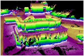
Color scale show change in elevations’ in this 100 year old farm house.  In  a 3D Laser scan

Some of our more memorable projects included:

Providing our client with a floor as built of a building that was approximately 500,000 square feet.  The client was a contractor and they needed it for their client to determine that the floor met the specification for being level.  In two days we scanned and captured about 10,000,000 points.  Then we presented the data to the client firms in colored contours that we 1/8th inch contours and every time it changed by another 1/8 inch the color also changed.  Ultimately we provided them a 10 foot grid and the floor did meet the specification.

We have surveyed structural walls that were either settling  or sinking and we survey the amount of settlement over a period of time and showed graphically and with excel spread sheet how much movement we detected.

We have surveyed mines both above ground and below and underground and were able to give the client a map of the existing conditions.  In doing this we also were able to keep our crews safer and they did not have to go into the working faces of the mines which can be very dangerous.  Because of the range the laser collects data we were not with in what the miners call the “working face” area which is much more susceptible to falling rock and surrounded by large heavy moving equipment.

As we go forward in this publication we will talk more and more about the different types of projects we have worked on and how the scanner was used to collect information that otherwise could not be collected.