Posts

The field scanning process: How to get the best results

Once your laser scan has been ordered, there are some things you can do to prepare for our crews.

First, prior to the scan, have someone (preferably a knowledgeable project manager) onsite to communicate with the scan team when they arrive.

Make sure your plant managers know crews are coming. If there is a local safety course that needs to completed or specific plant instructions, let them know upfront. Also let crews know if there is special gear they may need like moon suits, hairnets, safety glasses or ear protection.

The project walk-through is a very valuable process because this is where we determine the location of the scanner setups. Let crews know what is most important and what is less important. If a major conduit with fiber optics, a power transmission conduit, or particular piece of machinery is important to your project, for example, it is important to let the scanning crew know.

Also make sure the scanning crew has a contact that they can call if they have questions or need clarification mid-scan.

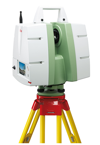
Crews will place targets around the scan area to tie all of the scans together and will remove them upon completion of the site visit. Once they understand the limits and the prime areas of interest, the scanning process will begin.

Though it is great to watch them work, these teams are professional and the less direction they have, the better the results! A typical job can take two days to several weeks. Each night, scanned data for the day will be checked to make sure there are no gaps or geometric issues with the data.

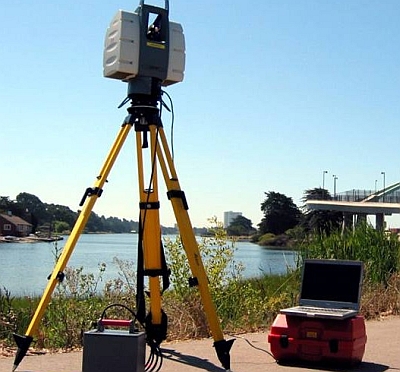
For black and white scan data, the process is simply this: scan, move to a new location, scan, move to a new location, etc. For color data, a set of photographs is added to the process: scan, remove the scanner, add a camera, take seven photographs (six at 60-degrees horizontally, one straight up), move the scanner, take photos at the new location, replace the camera with the scanner, scan, and repeat this sequence throughout the site.

This allows our crews to produce high-quality TrueView files. When they get into a rhythm, the above sequence maximizes efficiency up to 100%.

Post Processing

When the scan data comes back into the office, data is exported from the crew’s field laptop to the desktop. On large jobs, this will take several hours.

Next, if there are color photos, the color photo data is downloaded and registered to the point cloud. This process can take 5-10 minutes per set up. Around 100 set-ups can take 15 hours of technician time. (If there is only black & white data, we skip this step.)

Once the photo data is added to the raw data, the target information is then added to the data set. The data is then run through the final registration process. This program compares the data set to all the other common data sets and produces the final registered point cloud.

The point cloud is then tested visually and geometrically to make sure there are no errors. This is done by cutting it like a wedding cake to see that all of the horizontal surfaces line up and also looking at elevation views and pipe runs to make sure that these are consistent throughout the cloud.

After these are tested, the final registered point cloud is ready to be used. Files are then loaded on to a hard drive and shipped to you, the customer!

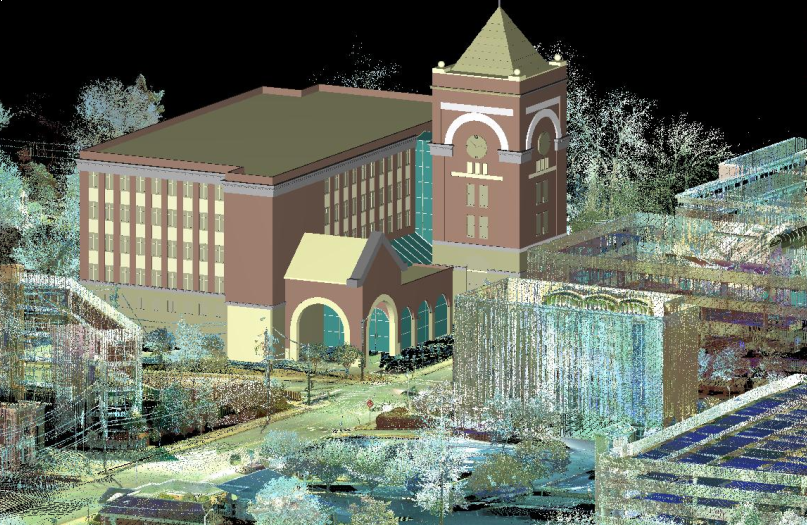
Now that you have the point cloud data, what do you do with it?

Registered point cloud data can be exported into AutoCAD, MicroStation, Bentley, Revit, Autodesk Recap and many other computer programs. Designers can then take this data and design and model it in a 3D environment.

A TrueView map of the site showing 3D spherical data in black & white or color can be created. You can measure between points in the point cloud with this free program.

Warning: We always recommend that for precise measurements, you use the point cloud information and not TrueView. The angle of the view can affect the measured distance in TrueView. At a minimum, check the measurement from several different views.

Computer models can also be built in Revit, AutoCAD or MicroStation and delivered to the client. These models can be imported into the point cloud and then “clashed” to see if the new model interferes with the existing point cloud.

Want to learn more? Contact us today to learn if a laser scan is right for your next project.

###

Tate Jones has over 40 years of experience in land and aerial surveying and was one of the country’s earliest adopters of 3D laser scanning technology. A nationally recognized expert in the field of 3D data capture, he has worked with hundreds of clients in the engineering, architectural and construction industries. Contact him at tjones@lasurveying.com or visit www.landairsurveying.com.

3D Laser Survey: The new industry benchmark

Having just turned 60 years-old, I hit one of the major benchmarks in life.

When I was younger, I can remember thinking 30 was as old as you could ever get. Time changes the way we think about things.

I started my business in 1988 and still enjoy running our firm 25 years later. I have lived through the changes from ink on Mylar to Cad drawings, the introduction of GPS and the effect the internet has had on all of our lives. The latest change in the engineering world is the natural progression from 2D plans to 3D deliverables.

In 2005, when we started collecting data with high definition lasers, we were on the cutting edge. Today, this method is becoming even more mainstream.

Most of the sales we made in those first years required us to collect data in 3D and turn it into a 2D AutoCAD or Micro station deliverable. Today, probably 15-20% of our clients just ask for the “point cloud” data and use software that is written for their design and construction needs, making the information much more user friendly. How the industry has changed.

Transportation
For many decades, we went out and surveyed roads the same way using digital survey equipment. While we still use traditional GPS and total stations, we incorporate 3D laser scanning more and more.

We were on teams that won some of the intersection projects north of Atlanta on I-85. On all of these projects, we scanned the roads, ramps, bridges and main line. Why? Because safety is always #1. Our surveyors don’t go into traffic or stand by the road unless there is no other way to do the job.

We were also able to produce very precise useable bridge data in a relatively short timeframe, which allowed our clients to begin preliminary planning. Another benefit is that the free point cloud viewer that comes with every project allows the client to visit the site, make precise measurements, and view the project in 360-degree photography without leaving their desks.

Nothing is more valuable than a site walk, but trying to remember if there were four light poles or six at a crucial intersection can be solved instantly with the click of mouse. Micro Station, AutoCAD and Revit now have programs that can import 3D survey data directly into the design file, which is a very big advantage for designers.

Structural Elements
In 1978, I was asked to survey the interior of Lenox Mall in Atlanta and produce an as-built for a structural survey. We used a steel chain and offset lines and it took many days to document simple column lines.

Now we can capture and document the most extreme and difficult data in just a few hours. We regularly use laser scanners to document wall failures, roof collapses, and to certify that massive complex structures are build per the design drawings.

Imagine having to perform a complex as-built survey of something like the Georgian Dome without a laser scan. It would be unthinkable! Likewise, engineering for tank farms and pipe transfer areas are much easier to document with a scanner.

Today, more and more clients are asking for a “laser survey” and then importing the registered point cloud data to begin designing the “fix.” As a result, travel expenses are roughly one third of what they were before.

Architecture
New Greenfield architectural as-builts are required and one day in the not too distant future they will require a laser scan point cloud to document the final conditions.

The real advantage in the 3D world is when you can scan older buildings that are not uniform and not consistent prior to construction and find all of the asymmetrical areas that will give a contractor and owner fits when construction begins.

For many reasons, we are documenting existing conditions in older buildings and in some cases they have very nice architectural features built by real artisans that we are able to capture to give the client a much clearer picture of what is there.

Older buildings have sagging floors, walls with varying thicknesses, and sometimes no interior air-conditioning or duct works. These are all areas where 3D technology is the only way to fly.

MEP Energy and Complex Plumbing
We call these highly complex environments. The original laser scanner was invented to map oil platforms and massively large refineries so that engineers could document and design the required elements correctly.

Unfortunately, there was no other way to do this. Weekly, I talk to clients who make 4-6 trips to jobs to check and recheck hand measured structures. Good news: there is no reason to do this ever again! Using a laser scanner is cheaper, faster and more accurate and once you capture the data, you have it forever. There is no better tool.

In this field, “smart point clouds” have turned from a dream to a reality. There are now programs that can automatically turn a point cloud into a series of pipes. Though it is not perfect yet, it is so much better than what was available in the past. The time it takes to model a pipe room is one third the time it took five years ago.

Most serious pipe designers are requesting laser scans on large projects. The new software models and performs clash detection and can export the data into many mainstream Cad platforms. This is now considered an industry best practice.

Low-tech Solutions
When we began in 2005, high speed laser scanners were our main tool. But unless the renovation was complex, the cost benefit for documenting relatively simple environments like hotels and commercial space was not very high.

For the past year, we have been providing Revit models of existing buildings cheaper and more efficiently than ever before. Previously designers sent interns or fresh college grads in the AEC industry to measure the space, who then took the data back to build a model.

Now we can measure the interior with a handheld laser and when we leave the building, the model is complete. Many projects can be completed in a single day. With a few hours of clean up the next day, the project is finished and out the door.

Our price is generally very competitive compared to the cost of sending designers to measure the space and the advantage is that they are designing and generating revenue. It is a win-win.

I am often asked by designers why they have to change the way they have been designing when it has been successful for decades. The answer is simple: there is a better way to do it.

With the advent of 3D printers, many designs will be printed and go straight from design to printer to the construction site with no human intervention.

The construction industry is changing, as are the designers who shape that industry. We have reached the new benchmark of 3D survey, design, fabrication and testing and there is just no going back.

###

Tate Jones has over 40 years of experience in land and aerial surveying and was one of the country’s earliest adopters of 3D laser scanning technology. A nationally recognized expert in the field of 3D data capture, he has worked with hundreds of clients in the engineering, architectural and construction industries. Contact him at tjones@lasurveying.com or visit www.landairsurveying.com.

Rapid As-Builts for the Retail Industry

In the real estate market, timing is everything.


Those who have better and faster information win. This is what inspired LandAir Surveying to develop Laser Measuring to BIM technology to quickly document existing as-built conditions. 


Many retail projects begin with an existing space needing a build out for a new tenant. Field measurements must be taken to document the existing as-built conditions of the current space and owners use these as-builts to evaluate tenant requirements, determine rental rates, and create design plans. 


Traditional methods of field measuring are slow, inaccurate, and inefficient. In contrast, LandAir Surveying’s Laser Measuring to BIM technology provides a better way to connect the dots from prospect to rent-paying tenant.


As we are closing in on the start of the International Council of Shopping Centers (ICSC) Annual RECon Conference, I thought it would be a good time to explain how Laser Measuring to BIM is revolutionizing as-built field measuring.

How it works

Laser Measuring to BIM works based on a blue-tooth enabled BIM workstation. LandAir’s survey team uses a laser rangefinder to transmit very precise field measurements into software that enables our technician to draw in Revit, Autodesk’s 3D software solution. 

Once the entire space is drawn in Revit, field technicians perform quality control on the data and finalize the as-built model. The Revit model data will be verified again back in the office and the final deliverable, usually either AutoCAD drawings or the 3D Revit model, is generated. 

Accuracy and speed: The best of both worlds

The Laser Measuring to BIM approach produces a more accurate depiction of existing conditions than traditional methods, because the field technicians see the final drawings as they are mapped in our CAD software. The ability to field-verify measurements while on site not only produces more accurate data, but saves time over the traditional field measurement to office drawing back to field to verify and catch what you missed technique. 

This workflow typically allows drawings to be created in hours as compared to the days traditional methods took. Because this technology can generate as-built documentation so rapidly, it expedites the rest of the process to move a tenant into the vacant space. 

Start construction faster

Producing as-built documents rapidly and accurately allows owners, brokers, and property managers to more efficiently submit sites for approval to the tenants’ corporate design team.

Since the plans are presented in a very user-friendly manner, decisions regarding the suitability of a space are easily determined. This reduces the due diligence time required by prospective tenants. And since the space-defining measurements come from an unbiased third party, rate calculation and space designation can be agreed upon faster. 

All of this leads to the design team beginning on design documents and demolition plans more quickly. Additionally, the precision of laser measuring and field verification of the Laser Measuring to BIM workflow gives designers confidence that the as-built conditions are correct and the production format (AutoCAD or Revit) is something that they can use immediately. 

Deliverables

Laser Measuring to BIM can produce both 2D drawings and 3D models with as much information, or as little detail, as needed. Some brokers may only need a simple PDF of the floor plan with doors, windows, and walls. 

On the other hand, an architect doing a full tenant build out may require a reflective ceiling plan, kitchen MEP systems, and utility plan with outlets and switches. Regardless of the need for information or the level of detail required, Laser Measuring to BIM will produce as-builts faster and more accurately than any field measuring technique used in the past.

Are you planning to attend the ICSC RECon Conference this year? If so, e-mail us. We would love to connect!

###

Mitch Dorsett has over 15 years in the building and construction industry and serves as director of business development for LandAir Surveying. Mitch is rapidly becoming an expert in 3D data capture and virtual design and construction, having attended and represented LandAir’s laser scanning capabilities at SPAR, RTC and Autodesk University in 2012. Contact him at mdorsett@lasurveying.com or visit www.landairsurveying.com.

Five reasons to consider laser scanning in 2013…

Blog 5 photo c10 scannerI hope you are off to a wonderful New Year! In the theme of the New Year, I continue to be amazed at all of the new applications for laser scanning that our clients are coming up with or projects they inquire about measuring.

Hopefully this blog will inspire you to think of opportunities to utilize our services in 2013 to make your next project even better.

As-built data capture has always been a challenge for the AEC community and owners of assets. The outdated methods of gathering data are time consuming and lack accuracy and utilizing these record drawings can be inexact.

LandAir Surveying uses the latest technologies to help our clients. Whether you are looking for accurate as-built floor plans, historic preservation of a structure or MEP surveys in the plenum of a ceiling, we have an accurate and cost-effective solution for you.

Over eight years ago, we began utilizing the revolutionary technology of laser scanning. Our first laser scans were for the transportation industry, performing bridge surveys. Through these and other projects, we found laser scanning to be superior to traditional methods of data capture for a number of reasons:

#1: They are more precise.

A laser scan takes multiple scans to collect millions of data points. These scans are then registered together to generate a single three-dimensional “point cloud” that can be measured accurately and provides distances and elevations between points on X, Y & Z coordinates.

#2: They are versatile.

Laser scans can produce (when used with digital color photos) survey quality files, fly-through videos, BIM Models and CAD drawings.

#3: They are fast.

A single laser scan can be collected in around six to eight minutes. This enables crews to take many more scans and capture more detailed data than ever before. It also allows for accurate surveys to be done with minimal interruption to building occupants.

#4: They are safe.

Laser scanning provides a safer environment and allows crews to measure in places that would have previously been impossible.

#5: They save you money!

Finally, laser scanning almost always pays for itself. Here are a few examples of ways laser scans can save you money on your next project. Here are a few examples of ways laser scans can save you money on your next project:

  • You can always revisit the original scan multiple times from your computer desktop without the time and expense of traveling to the site again and again. With a laser scan, you can even revisit the site from your desktop years after the initial scan.
  • The quality of data collected can minimize or eliminate the need for construction reworks and field retrofitting.
  • The number of change orders due to erroneous design and unknowns in the field are dramatically reduced.
  • Material waste is reduced and the amount of production in the shop is increased.
  • Coordination between design and construction teams is greatly improved by providing visual documentation for discussion.
  • The speed of design is increased by providing accurate as-built conditions and clash detection.
  • Bid documents can be created from as-built data, resulting in lower-priced bids and a quicker schedule.

As you can see, the reasons for laser scanning are compelling. But what types of projects are best suited for this technology? In our experience, we have seen the greatest return on investment for laser scanning on projects that are complex and difficult to measure. Those projects with precise measurement requirements and a required speed of data gathering typically yield the greatest return on investment.

We have scanned miles of tunnels, airport conveyor systems, MEP structures that look like pipe “spaghetti,” hotel and casino atriums, and theaters and stadium grandstands with thousands of different sized structural beams. Laser scanning was by far the best solution for these projects.

While complex projects are great opportunities to utilize laser scanning technology, other advances in virtual design and construction solutions have allowed us to provide results for less complex environments.

New software and measuring solutions allow us to provide detailed as-built drawings and 3D models for hotel rooms, retail spaces, classrooms and offices with amazing speed and at a greatly reduced cost-per-square-foot over traditional architectural surveys. Field measurements to productions of floor plans and even Revit models can now be delivered in days.

From the industrial, manufacturing and energy sectors to hotels, hospitals and retail spaces – LandAir can provide solutions to make your next project more efficient and affordable.

###

Mitch Dorsett has over 15 years in the building and construction industry and serves as director of business development for LandAir Surveying. Mitch is rapidly becoming an expert in 3D data capture and virtual design and construction, having attended and represented LandAir’s laser scanning capabilities at SPAR, RTC and Autodesk University in 2012. Contact him at mdorsett@lasurveying.com or visit www.landairsurveying.com.

Autodesk University 2012: watching an industry grow up!

Attending and exhibiting at shows like Hexagon, Spar, and Autodesk University is always fascinating because you get to interact with clients all over the country and see what’s new in the industry.

This was our first time exhibiting at Autodesk University, but having been to three conferences in Las Vegas in one year, I was quite familiar with the surroundings. At this year’s show – which was attended by over 8,000 people from 102 countries – what I saw was an industry that has grown up and is beginning to make a real impact on design and construction.

I remember in 1986 when a new drafting program named AutoCad came out and everybody was debating if it would become the standard…it did. And it brought with it – along with the digital age and computers – the plotters and all that went with the introduction of this new paradigm.

Most of us waited to see how it would be received in the industry, but then – as now – it proved to be a very valuable tool.

And just a few years ago, we were all still discussing the advances in AutoCAD and Civil 3D.  Though we knew these programs would remain relevant, it was evident from all of the different software that interacted inside of Revit and enhanced the user experience that the world of 3D design was here to stay. (As a friend of mine said not long ago, “If you are not designing and interacting in 3D and models, you are quickly going to be obsolete.”)

Autodesk University 2012 showed us how design is being done today and where it is going in the future. One of the more interesting observations was that besides the architects, engineers and designers, there were contracting companies, retail companies and owners all talking about the new Autodesk programs that were being used in the workplace.

There was lots of talk in these groups about building “Revit families” specific to their business types, as well as discussions around how to mix the contractors (who have the knowledge about how a building is built in the actual world) with the BIM modelers so that the models are also constructible.

This will be a big challenge. Contractors and superintendents who know how to pour a slab and build 20-story buildings have knowledge and insight that is absolutely critical to building a proper BIM model.

As any techno geek, I am always very interested in the new products on the exhibition floor and the showcase included hundreds of third-party vendors developing exciting products that work alongside Autodesk.

There were lots of new software and hardware lines in the 3D laser scanning industry, as well as new software offerings for BIM models, Revit technologies and GIS products. But for me, the most intriguing products were related to 3D printing applications.

These fabrication and modeling solutions enable products to be created directly from their computer models.

Almost anything you could imagine – from cars to motors to guitars – was printed and on display. Though 3D printing has been a popular topic in recent years, it was there, it was real, and it will definitely change how items are built in America and around the world.

At the conference in Vegas, there were actual printers producing objects out of wood, metal and polymers. The only difference was whether the printer was loaded with plywood or metal.

BIM is an acronym for Build Information Models, meaning to build computer models that have built-in intelligence. What I observed was BIM in the context above – building models and objects with just the information in a computer.

My, how we have grown.

###

Tate Jones has over 40 years of experience in land and aerial surveying and was one of the country’s earliest adopters of 3D laser scanning technology. A nationally recognized expert in the field of 3D data capture, he has worked with hundreds of clients in the engineering, architectural and construction industries. Contact him at tjones@lasurveying.com or visit www.landairsurveying.com.

Where we are now…and where we’re going.

As 2012 winds down and we get ready to head to Las Vegas for the Autodesk University conference, I look back at the strides that have been made in the 3D world and all of the associated hardware and software in our industry.

Not only is there new technology being used and accepted, but the demand for more BIM products, users, and technologists has grown faster than ever. I have also watched with great interest the wave of corporate acceptance that was not there even three years ago.

There is still much ground to be broken, but wow – what a year!

New Software

Take software, for example. As I travel around America and talk to user groups and clients, the one thing I am always asked is when will it be easier to model point clouds into usable entities?

There is much research going on to solve this challenge. Though I have no commercial interest in this firm, I believe one of the ones to watch in this space is ClearEdge 3D. Their EdgeWise Plant software is pushing the barriers away for modeling point clouds.

Personally, I believe that within the next three years, this major barrier we face now will be a minor issue and point cloud use will continue to grow and expand.

The other great leap in technology is that most of the major software packages have updated their products to accept point clouds as a layer. This means that most of our clients in the architectural and MEP worlds can now import our point clouds into their design software and greatly enhance their designs.

Just three or four years ago, using point cloud data required modeling and this limited the market to mechanical and structural engineers and various contractors with specialty software.

Today, because all Revit users can import point cloud data, the need to model everything in a scan project has been greatly decreased. This is a big deal! Now, instead of having to pay for an expensive model, end users get all of the benefits of point cloud precision without the associated costs of modeling.

Not to be overlooked, there are still issues that will need to be ironed out in inserting point clouds into design software, but they will be overcome with time.

For example, if you are working in Inventor to model plant process data, it is best if the project is modeled from start to finish in Inventor. Similarly, if it is to be modeled in Revit, it is best that it be modeled from start to finish in Revit. There are no readily available universal translators to move from a model that was created in Cyclone to a model in Revit while keeping the full integrity of the original model.

Though the data itself is globally transferrable, the structure of the models, entities, families and libraries requires more work to be done in this area.

New Hardware

Last year, I predicted that the hardware in our industry was set and that most of the changes would come in the form of software. On this point, I was wrong.

Several changes have occurred that continue to advance the hardware. For example, The Faro Focus 3D has broken the price barrier. Prior to its release, most scanners started around $80,000 and went up to $200,000. The Focus was released at about $50,000 and has caused price adjustments throughout the industry.

I believe this trend will continue and prices will continue to go down. This is both a good and bad thing for the industry. As prices go down, more people with marginal training and experience will begin to use scanners and bad point clouds will become more of a problem.

There is a saying in our industry that “one bad point cloud kills a lot of clients.” Indeed, this is true. I have talked to clients who tried laser scanning nine years ago, had a bad experience, and will not use it again to this day. The problem is not that scanners are getting more affordable, but that there are still no national standards in the industry.

The upside is that with a lower cost competitor, vendors must consider what value their laser scanners bring that others do not.

Cool New Technology

Two things I am really interested in and know will change the playing field moving forward are   aerial drones and augmented reality.

These two technologies are growing fast and have many great uses. A traditional helicopter used to map utilities and large areas generally costs about $25,000 per day. A one-meter drone quadripod, on the other hand, costs about $2,000 per day.

Though there are unique tasks that the smaller one-meter drones can do that the helicopter is currently doing, there are other tasks that the smaller drones can perform that traditional helicopters cannot do. For example, smaller drones can more effectively and safely map underground pipes, mines and tunnels.

Currently, to send two scanner technicians into a tunnel requires about six surface and sub-surface support staff. An unmanned drone with avoidance technology would be a great solution.

Augmented reality and the ability to project 3D images easily and to large groups is available and is changing the whole world of education. A small but growing company, ViziTech USA, is doing very creative and trendsetting work in this area.

This is where the science of 3D technology is repackaged so that the average person can use and understand it. This is a powerful tool and will lead to great changes in many industries and educational processes. For more on augmented reality, read our recent blog post here.

The design and construction of future projects will still require the same basic processes that are required today. But the use of precision data before, during and after construction – and the visual way the data can be viewed – will greatly reduce errors and downtime events.

###

Tate Jones has over 40 years of experience in land and aerial surveying and was one of the country’s earliest adopters of 3D laser scanning technology. A nationally recognized expert in the field of 3D data capture, he has worked with hundreds of clients in the engineering, architectural and construction industries. Contact him at tjones@lasurveying.com or visit www.landairsurveying.com.


Young innovators push 3D design and high speed data capture to new heights

When we were asked to bring our booth and support the 2nd Annual Revit Technology Conference in Stone Mountain, Georgia, last week, I didn’t know what to expect. But I’m glad we went because we saw the future – and it’s very bright.

For BIM managers and designers, this conference was a look through the hourglass of the future at the world of design and one thing is for certain: gone are the days when firms could avoid BIM, 3D Cad modeling and laser scanning and still hope to be competitive. What I saw were bright young innovators already pushing the technology of 3D design and high speed data capture to the limits.

It was very refreshing to attend a conference where presenters and attendees agreed that 3D laser scanning was the best tool to use in many design situations and were openly discussing how they currently used the technology in innovative ways.

The largest 3D scanning show I attend every year is SPAR. I had the same feeling at the Revit Technology Conference last week that I had at the third SPAR show back in 2005 when laser scanning was still a new and relatively untested technology. The quality of what was being presented at the Revit conference – and how and who was presenting – was way up on the charts.

Around the showroom floor, there were the larger suppliers of the Revit technology, who were very knowledgeable about new improvements to the products, alongside many boutique firms that were selling all types of software to make the design process in Revit easier and more organized.

There were also other groups selling “cloud” technology that provided a new, more efficient vision of the cloud. While most of us already have data on our iPhones, it will be a short time before we will all have our data in the cloud and projects will be able to be worked on by anyone, anywhere with just a password and a computer.

On large mega-projects like new airports and major industrial facilities, multiple design teams in multiple cities will be able to work on the same cloud-based data at the same time. It will change the way we do things forever. Yes, there will still be security issues and priority issues, but ultimately that’s where we are headed.

Why have one computer process for one million seconds to solve a data set if you can have a million computers process for one second? It’s not quite that simple, but that’s the goal.

The speakers were great, too.

My favorite was Dick Morley. His opening presentation was in the form of a fireside chat with Brad Holtz serving as the interpreter. (I say interpreter because when the audience looked confused and a topic seemed to go over our heads, Brad would bring Dick back down to earth.)

Dick Morley invented the programmable logic controller, which pretty much controls all the electronic machinery in the world. To put it in prospective, that one device produces more revenue than all of Hollywood’s productions combined.

He also invented antilock braking technology, which revolutionized cars and greatly reduced accidents on the highway. (As a side note, he said that while the number of accidents decreased for many years, they slowly started going back up as drivers in America learned to drive closer using the antilock brakes. As the margin of error decreased, accidents increased.)

Dick also invented the cash register overlay that has pictures of food on it rather than numbers. This greatly reduced errors and increased production in the fast food industry.

Dick, who was trained in physics at MIT, had a clear message: “Look at where things are going and what needs to be solved and find the technology to solve it. Holding on to the way it has always been is just a reason to justify where you are – not a plan to move forward.”

I think this is true across the industry. The true leaders and innovators are not the ones who are really good at getting a piece of paper from the left side of their desks to the right, he said. The innovators ask, why paper?

Other interesting speakers shared new and innovative ways the power of 3D is being used across the spectrum. Kelly Cone with the Beck Group gave a very thorough presentation of using modeling in a major construction project and how the model was embraced and used by many of the subcontractors on the project.

They even built a “construction” roll-able computer workstation so the subs could walk over in real time, look at their section of the project in 3D, and understand the intent of the designer.

He also talked about how having access to quick laser scanning information helps designers and contractors come up with workarounds in tight spots.

The conference had attendees from most of the continents in the world and it was evident that critical mass has been reached and that the tipping point into 3D design technology is complete.

The transition away from 2D drawings and flat surveys is history and 3D models and clash detection and design testing prior to construction is now the new standard.

###

Tate Jones has over 40 years of experience in land and aerial surveying and was one of the country’s earliest adopters of 3D laser scanning technology. A nationally recognized expert in the field of 3D data capture, he has worked with hundreds of clients in the engineering, architectural and construction industries. Contact him at tjones@lasurveying.com,  tjones@3DLaserSurveys.com or visit www.3DLaserSurveys.com.