Posts

LandAir Surveying at Oak Ridge Safety Fest 2013

LandAir Surveying is in Oak Ridge, Tennessee, today attending the Oak Ridge Safety Fest 2013.

Oak Ridge is home to much manufacturing, most notably the federal contractors providing services to the Department of Energy (DOE), including such institutions as Oak Ridge National Laboratories (ORNL) and the Y-12 National Security Complex.

The event includes four days of free safety training classes, many of which lead to certification. This focus on safety helps ensure a productive work environment for us all.

Are you in Oak Ridge this week? If so, let us know! We’d love to connect….

###

David Headrick has over 20 years of experience in the surveying, engineering, and legal industries, both as a project manager for LandAir Surveying and as a lawyer in private practice.  He has represented numerous land surveyors, designers, architects, contractors, and other industry professionals throughout his career.  Today, David serves as an executive and project manager for LandAir Surveying Company, Inc., focused on developing and managing the company’s 3D Laser Scanning Division.  Contact him at (865) 599-0148 or dheadrick@lasurveying.com.

LandAir Surveying at the American Society of Civil Engineers (ASCE) annual meeting…

LandAir Surveying will be presenting on 3D laser scanning to the American Society of Civil Engineers (ASCE) annual meeting for its Tennessee section this Friday, August 23. The all-day program will be held at Buddy’s in Bearden, Tennessee, and will feature multiple speakers. Our own David Headrick will be presenting at 1:00 PM (EST)!

3D laser scanning: the perfect choice for fast-growing automotive industry

The automotive industry is firing on all cylinders – especially here in Tennessee. For the fourth year in a row, the state has been ranked No. 1 in auto industry strength.


Not only has Nissan been operating here for 30 years, but Tennessee is also now home to General Motors and Volkswagen’s operational plants, as well as Magneti Marelli and a number of original equipment manufacturers. In the last year, Tennessee hosted 44 automotive projects generating over $1 billion and thousands of jobs.


Earlier this month, GM announced plans to add 1,800 jobs at its Spring Hill assembly plant over the next three years so that it can begin building two new midsize vehicles.


In June, Nissan Motor Co. announced that it will add 900 jobs at its plant in Smyrna, just northeast of the GM plant. Also this month, Nissan announced plans to up production of its electric motors in its engine factory in Decherd, Tennessee. The plant is already staffing up to launch a third work shift to accommodate production.


As the automotive industry continues to grow, 3D laser scanning can play a major role in the redesign and construction of these plants.


This high definition scanning technology is the perfect tool to help automotive manufacturers retool their assembly lines, update their as-built drawings, and maximize efficiency of their production line layout.


How, exactly, can 3D laser scanning help?


#1: Reduced risk. Not only is laser scanning safer than traditional scanning methods because it allows crews to measure in places that would have previously been impossible, 3D laser scans also save money by eliminating the need for construction reworks and field retrofitting. Because of the quality of the scanned data, the number of change orders due to design flaws and unknowns is dramatically reduced.


#2: More precise. A laser scan takes multiple scans to collect millions of data points that are then registered together to generate a single three-dimensional “point cloud” that provides accurate distances and elevations between points on X, Y & Z coordinates. This accuracy provides the ability to perform better simulations and visualizations for training and monitoring purposes.


#3: Regulatory compliance. As governmental regulation and scrutiny increases, factory owners must ensure the as-built and as-maintained condition of production assets is in compliance. Laser scanning can be used to ensure plants are always safely within the regulatory guidelines.


#4: Huge cost savings. Laser scanning enables designers and engineers to revisit the original scan multiple times without having to physically return to the jobsite. Coordination between design and construction teams is greatly improved by providing visual documentation for discussion, and expensive construction reworks are greatly reduced.


Additionally, schedule compression of as much as 10% has been reported when 3D laser scanning has been deployed. This means big savings – especially on projects where outage time can cost as much as $1 million per day!


Conclusion

As the automotive industry continues to expand, 3D laser scanning technology can be an invaluable asset to the construction and redesign efforts of auto manufacturers to increase accuracy and efficiency while significantly saving both time and money.


###


David Headrick has over 20 years of experience in the surveying, engineering and legal industries, both as a project manager for LandAir Surveying and as a lawyer in private practice.  He has represented numerous land surveyors, designers, architects, contractors and other industry professionals throughout his career.  Today, David serves as an executive and project manager for LandAir Surveying Company, Inc., focused on developing and managing the company’s 3D Laser Scanning Division.  Contact him at (865) 599-0148 or dheadrick@lasurveying.com.

3D Laser Scanning for Renovation of Healthcare Facilities

As a facility, hospitals and other healthcare buildings present a unique situation.

They have the aesthetic needs of a hotel or retail store, but the engineering requirements of an industrial or mechanical facility. These competing needs make space allocation difficult for design, construction, and operations and when renovations are due, accurate as-built information is absolutely critical.

3D laser scanning delivers perfect as-built information to meet the MEP and architectural needs of even the most complicated facilities.

Changes are always afoot in hospitals

Hospitals facilities are anything but static. Improvements in technology constantly call for new equipment and can shrink or modify the size of existing equipment. 

Equipment and mechanical rooms in hospitals are notoriously crowded. Walls, ceilings, kiosks, laboratories, and operating rooms are virtually full of pipes, wires, conduits, and other tools of the MEP (mechanical, electrical, and plumbing) world. 

This makes renovations difficult for both design and construction. 

There is a human factor, too. Office layouts change as employees are churned (or “moved” in facilities management terms). Departments often have to compete for space and square footage comes at a premium!

The health and safety of employees is also a consideration. Hospitals must comply with statutory requirements related to office layouts including the minimum amount of space per employee, security features, fire safety protocol, ventilation, temperature control, restrooms, dining facilities and more.

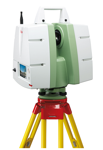
3D Laser Scanning: Perfect asbuilt information

3D laser scanning allows architects and engineers to design renovations from perfect as-built information. This directly addresses the need for accuracy within the tight tolerances of the hospital environment. Since human measurement error is eliminated, re-designs are greatly reduced and errors and omissions on the construction and architectural plans are also of no consequence.

3D laser scanning also gives contractors the upper hand. Since designs are based on actual existing conditions, the contractor can be more confident that it is constructible as designed.  Plus, precise material schedules developed from the model help avoid cost overruns.

The contractor can also use “clash detection” to determine exactly what must be moved or removed to complete the renovation. This technique compares the scanned as-built world to the construction plans and shows which areas are trying to occupy the same space. This significantly reduces change orders.

Owners and facilities managers also save money through efficient design and construction, as they can use the 3D picture of existing site conditions as a decision-making and communication tool during construction and a facilities management tool afterwards.

How it works

A 3D laser scanner uses harmless light rays to collect the 3D location of every object and surface it can “see” from where the instrument is set up. Scanners automatically rotate 360 degrees on a tripod, sending and receiving these light rays in all directions. In about five minutes, the scanner setup is complete and millions of data points have been collected. 

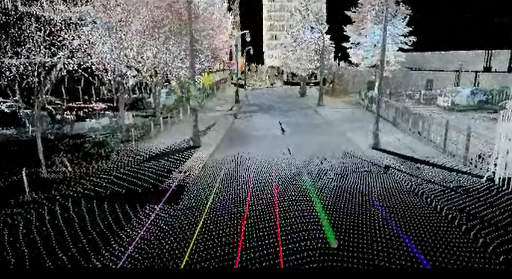
This data, which is known as a “point cloud,” is a perfect 3D asbuilt of existing conditions. The point cloud can be used by itself or modeled in a software program.

Advantages over traditional as-built techniques

3D laser scanning has many advantages over traditional measuring techniques including:

  • Accessibility: 3D laser scanners collect information from areas that can be seen but not easily accessed. For instance, scanners can collect information about MEP pipes and wires running along ceilings and other inaccessible areas.
  • Speed: Each scanner setup takes less than five minutes, so scanning crews can be in and out of an area quickly, without disturbing patients and without compromising the integrity of the data.
  • Safety: Since the scanners use harmless light rays to take measurements, neither patients nor field crews are affected. In fact, field crews do not have to be in a place to measure it.
  • Detail: No other data collection system records such precise information. Architects can see finishes, molding, and other aesthetic features and engineers can measure the locations of all objects seen by the scanner.

Conclusion

The strengths and efficiencies of 3D laser scanning are extraordinarily applicable to the unique environment of healthcare facilities. From design through construction and facilities management, all parties benefit from the precise as-built information given by this remarkable technology.

###

David Headrick has over 20 years of experience in the surveying, engineering, and legal industries, both as a project manager for LandAir Surveying and as a lawyer in private practice.  He has represented numerous land surveyors, designers, architects, contractors, and other industry professionals throughout his career.  Today, David serves as an executive and project manager for LandAir Surveying Company, Inc., focused on developing and managing the company’s 3D Laser Scanning Division.  Contact him at (865) 599-0148 or dheadrick@lasurveying.com.To view his LinkedIn profile, click here.

ICSC RECon Packed with Optimism

Las Vegas hosted the annual ICSC RECon Conference last week – the largest retail real estate convention in the world. This year had more than 35,000 attendees and a record number of individual companies. Most attendees were packed with meetings and the tradeshow floor was bustling with activity. 


The retail industry has definitely picked up momentum over the last few months and with the number of prospective sites and development renderings being displayed, it appears the next few years should be busy.  Many of the receptions and parties were back in full swing and the overall atmosphere was more upbeat. News on the home front was good as the Georgia contingent was represented by around 1,000 attendees. 


LandAir Surveying was busy discussing many new projects and exploring ways to assist in gathering as-built documentation. Two things I took away from the project discussions were:  


First, there is work out there and people are looking to make things happen! Deals are being done and getting valuable information into the hands of the parties doing the deals is in high demand. 


Secondly, because people need as-builts of existing space, this signifies that redevelopment is still very predominant. Many of the deals I saw represented in booths were infill projects, urban development and Transit Oriented Development (TOD).


While retail, and for that matter the economy as a whole, is not yet back to pre-recession days; there were many positive trends on display at the ICSC RECon Conference. Let’s hope this trend continues!          

###

Mitch Dorsett has over 15 years in the building and construction industry and serves as director of business development for LandAir Surveying. Mitch is rapidly becoming an expert in 3D data capture and virtual design and construction, having attended and represented LandAir’s laser scanning capabilities at SPAR, RTC and Autodesk University in 2012. Contact him at mdorsett@lasurveying.com or visit www.landairsurveying.com.

Rapid As-Builts for the Retail Industry

In the real estate market, timing is everything.


Those who have better and faster information win. This is what inspired LandAir Surveying to develop Laser Measuring to BIM technology to quickly document existing as-built conditions. 


Many retail projects begin with an existing space needing a build out for a new tenant. Field measurements must be taken to document the existing as-built conditions of the current space and owners use these as-builts to evaluate tenant requirements, determine rental rates, and create design plans. 


Traditional methods of field measuring are slow, inaccurate, and inefficient. In contrast, LandAir Surveying’s Laser Measuring to BIM technology provides a better way to connect the dots from prospect to rent-paying tenant.


As we are closing in on the start of the International Council of Shopping Centers (ICSC) Annual RECon Conference, I thought it would be a good time to explain how Laser Measuring to BIM is revolutionizing as-built field measuring.

How it works

Laser Measuring to BIM works based on a blue-tooth enabled BIM workstation. LandAir’s survey team uses a laser rangefinder to transmit very precise field measurements into software that enables our technician to draw in Revit, Autodesk’s 3D software solution. 

Once the entire space is drawn in Revit, field technicians perform quality control on the data and finalize the as-built model. The Revit model data will be verified again back in the office and the final deliverable, usually either AutoCAD drawings or the 3D Revit model, is generated. 

Accuracy and speed: The best of both worlds

The Laser Measuring to BIM approach produces a more accurate depiction of existing conditions than traditional methods, because the field technicians see the final drawings as they are mapped in our CAD software. The ability to field-verify measurements while on site not only produces more accurate data, but saves time over the traditional field measurement to office drawing back to field to verify and catch what you missed technique. 

This workflow typically allows drawings to be created in hours as compared to the days traditional methods took. Because this technology can generate as-built documentation so rapidly, it expedites the rest of the process to move a tenant into the vacant space. 

Start construction faster

Producing as-built documents rapidly and accurately allows owners, brokers, and property managers to more efficiently submit sites for approval to the tenants’ corporate design team.

Since the plans are presented in a very user-friendly manner, decisions regarding the suitability of a space are easily determined. This reduces the due diligence time required by prospective tenants. And since the space-defining measurements come from an unbiased third party, rate calculation and space designation can be agreed upon faster. 

All of this leads to the design team beginning on design documents and demolition plans more quickly. Additionally, the precision of laser measuring and field verification of the Laser Measuring to BIM workflow gives designers confidence that the as-built conditions are correct and the production format (AutoCAD or Revit) is something that they can use immediately. 

Deliverables

Laser Measuring to BIM can produce both 2D drawings and 3D models with as much information, or as little detail, as needed. Some brokers may only need a simple PDF of the floor plan with doors, windows, and walls. 

On the other hand, an architect doing a full tenant build out may require a reflective ceiling plan, kitchen MEP systems, and utility plan with outlets and switches. Regardless of the need for information or the level of detail required, Laser Measuring to BIM will produce as-builts faster and more accurately than any field measuring technique used in the past.

Are you planning to attend the ICSC RECon Conference this year? If so, e-mail us. We would love to connect!

###

Mitch Dorsett has over 15 years in the building and construction industry and serves as director of business development for LandAir Surveying. Mitch is rapidly becoming an expert in 3D data capture and virtual design and construction, having attended and represented LandAir’s laser scanning capabilities at SPAR, RTC and Autodesk University in 2012. Contact him at mdorsett@lasurveying.com or visit www.landairsurveying.com.

Going to SPAR International?

We are getting ready for the SPAR Point Group’s 10th annual conference “End to End 3D: Capture, Process, Deliver” in Colorado Springs, Colorado, April 15-18. This is the main event of the year for people in the 3D laser scanning business.

For starters, every manufacturer and software developer in the 3D laser scanning world is sponsoring the event and will be in attendance. We can expect to be dazzled by live demonstrations of the latest and greatest scanners, software, and technology. If you haven’t heard, many announcements have been made in the past few months about breakthroughs, innovations, and technological advancements.

The conference will also be a comprehensive educational opportunity with lots of classes and workshops. Just about every aspect of 3D laser scanning will be presented and discussed.

Attendees can also choose to concentrate on one of the offered tracks: Industrial Facilities, New Technologies, Civil Infrastructure, and Forensic & Security. We will try to check out some of them all. Please let us know if there is a specific topic you would like us to look into. After all, if you need it, we need to know about it!

The topics listed on the website include 3D laser scanning, structured light, LiDAR, photogrammetry, reverse engineering, 3D/4D GIS, Kinect, indoor/portable mapping, autonomous vehicles, mobile survey, point cloud processing, airborne LiDAR /terrestrial integration, open source, web sharing, VIM, augmented reality, 3D printing, simulation, and visualization.

Did I mention that one of the keynote speakers will be Michael Jones, chief technology advocate for Google? That one will certainly be well attended.

With all of these events, we just hope to be able to enjoy a little of Colorado Springs and the stunning Broadmoor Resort that is hosting the conference. Hopefully, we’ll get some better Spring weather!

###

David Headrick has over 20 years of experience in the surveying, engineering and legal industries, both as a project manager for LandAir Surveying and as a lawyer in private practice. He has represented numerous land surveyors, designers, architects, contractors and other industry professionals throughout his career. Today, David serves as an executive and project manager for LandAir, focused on developing and managing the company’s 3D Laser Scanning department. Contact him at dheadrick@lasurveying.com.

How 3D laser scanning keeps us safe…

All of the hype over 3D laser scanning often glosses over another critical advantage it has over traditional land surveying: safety.

When asked to go out and procure data, we land surveyors must go where the data is and some of these places can be very dangerous. With 3D laser scanning, data can be collected faster and less intrusively than ever before, keeping our field crews out of harm’s way.

Think about it: where do you typically see land surveyors? On the side of the road!

Roads are frequently included in all manners of land surveying. They can be boundaries for property or serve as access to new commercial developments. For surveyors who work for the Department of Transportation, their whole job could be comprised of roads.

We all know that pedestrians have the right-of-way, but anyone who has crossed a busy highway can vouch for the fact that cars and trucks rule the road. Anything that limits the amount of time our field crews stand on roads ultimately makes our jobs safer.

3D laser scanning improves safety in two ways. First, it significantly decreases the amount of time surveyors have to be out in the field. When fieldwork can be completed with less instrument set-ups, field crews spend less time standing on bridges, highway abutments and railroad tracks.

Second, since 3D laser scanning uses light to collect data without the requirement of a reflective mirror held by a rodman, field crews do not have to physically occupy every point that they collect. These points can be located after the data goes back to the office.

This keeps field crews from having to locate such features as road striping, small medians between busy roads, concrete highway barriers and railroad trestles.

There are plenty of other less common examples. For instance, if a building is unstable, such as after a fire or structural failure, 3D laser scanning allows the data to be collected from a distance.

Similarly, when it is necessary to locate rough geography like a steep slope or cliff face, 3D laser scanning can negate the need for fall protection equipment. This is even more true when it is necessary to locate unstable slopes and landslides.

So, while it’s great to talk about the fact that 3D laser scanning brings home more data at a higher quality than ever before, we also truly value that it’s keeping our people safe.

###

David Headrick has over 20 years of experience in the surveying, engineering and legal industries, both as a project manager for LandAir Surveying and as a lawyer in private practice. He has represented numerous land surveyors, designers, architects, contractors and other industry professionals throughout his career. Today, David serves as an executive and project manager for LandAir, focused on developing and managing the company’s 3D Laser Scanning department. Contact him at dheadrick@lasurveying.com.


Five reasons to consider laser scanning in 2013…

Blog 5 photo c10 scannerI hope you are off to a wonderful New Year! In the theme of the New Year, I continue to be amazed at all of the new applications for laser scanning that our clients are coming up with or projects they inquire about measuring.

Hopefully this blog will inspire you to think of opportunities to utilize our services in 2013 to make your next project even better.

As-built data capture has always been a challenge for the AEC community and owners of assets. The outdated methods of gathering data are time consuming and lack accuracy and utilizing these record drawings can be inexact.

LandAir Surveying uses the latest technologies to help our clients. Whether you are looking for accurate as-built floor plans, historic preservation of a structure or MEP surveys in the plenum of a ceiling, we have an accurate and cost-effective solution for you.

Over eight years ago, we began utilizing the revolutionary technology of laser scanning. Our first laser scans were for the transportation industry, performing bridge surveys. Through these and other projects, we found laser scanning to be superior to traditional methods of data capture for a number of reasons:

#1: They are more precise.

A laser scan takes multiple scans to collect millions of data points. These scans are then registered together to generate a single three-dimensional “point cloud” that can be measured accurately and provides distances and elevations between points on X, Y & Z coordinates.

#2: They are versatile.

Laser scans can produce (when used with digital color photos) survey quality files, fly-through videos, BIM Models and CAD drawings.

#3: They are fast.

A single laser scan can be collected in around six to eight minutes. This enables crews to take many more scans and capture more detailed data than ever before. It also allows for accurate surveys to be done with minimal interruption to building occupants.

#4: They are safe.

Laser scanning provides a safer environment and allows crews to measure in places that would have previously been impossible.

#5: They save you money!

Finally, laser scanning almost always pays for itself. Here are a few examples of ways laser scans can save you money on your next project. Here are a few examples of ways laser scans can save you money on your next project:

  • You can always revisit the original scan multiple times from your computer desktop without the time and expense of traveling to the site again and again. With a laser scan, you can even revisit the site from your desktop years after the initial scan.
  • The quality of data collected can minimize or eliminate the need for construction reworks and field retrofitting.
  • The number of change orders due to erroneous design and unknowns in the field are dramatically reduced.
  • Material waste is reduced and the amount of production in the shop is increased.
  • Coordination between design and construction teams is greatly improved by providing visual documentation for discussion.
  • The speed of design is increased by providing accurate as-built conditions and clash detection.
  • Bid documents can be created from as-built data, resulting in lower-priced bids and a quicker schedule.

As you can see, the reasons for laser scanning are compelling. But what types of projects are best suited for this technology? In our experience, we have seen the greatest return on investment for laser scanning on projects that are complex and difficult to measure. Those projects with precise measurement requirements and a required speed of data gathering typically yield the greatest return on investment.

We have scanned miles of tunnels, airport conveyor systems, MEP structures that look like pipe “spaghetti,” hotel and casino atriums, and theaters and stadium grandstands with thousands of different sized structural beams. Laser scanning was by far the best solution for these projects.

While complex projects are great opportunities to utilize laser scanning technology, other advances in virtual design and construction solutions have allowed us to provide results for less complex environments.

New software and measuring solutions allow us to provide detailed as-built drawings and 3D models for hotel rooms, retail spaces, classrooms and offices with amazing speed and at a greatly reduced cost-per-square-foot over traditional architectural surveys. Field measurements to productions of floor plans and even Revit models can now be delivered in days.

From the industrial, manufacturing and energy sectors to hotels, hospitals and retail spaces – LandAir can provide solutions to make your next project more efficient and affordable.

###

Mitch Dorsett has over 15 years in the building and construction industry and serves as director of business development for LandAir Surveying. Mitch is rapidly becoming an expert in 3D data capture and virtual design and construction, having attended and represented LandAir’s laser scanning capabilities at SPAR, RTC and Autodesk University in 2012. Contact him at mdorsett@lasurveying.com or visit www.landairsurveying.com.

3D Laser Scanning

Advances in 3D data capture are changing faster than ever. How can we help you in 2013?

First, let me say Happy New Year to all of our clients who have supported us for the past 25 years. We appreciate you and are honored that you choose LandAir Surveying to team with you on many interesting projects across America.

Over the past seven years of traveling down the road of 3D data capture and using multiple platforms for LiDAR data collection, we have seen this technology expand into almost every field of design, construction and manufacturing.

It has been fascinating to watch the world change from 2D plans to 3D data sets and models. And in the process, modeling is becoming cheaper, faster and easier.

Having attended international conferences and through speaking to groups across the country, we have seen and studied with interest what is going on in the U.S., Europe, Japan, India and Asia. The whole world of design and construction is making this shift!

Daily, we talk with firms both domestically and internationally about the diverse issues of 3D design and construction to equip us with the knowledge we need to be your trusted resource for new approaches to surveying projects.

For example, we have been producing surveys for the transportation industry since 1998. I can remember when we had to actually put our surveyors out in traffic (with approved safety measures, of course). Now, with our scanners, we can stay off the shoulder of the road and capture all the required data without putting anyone in harm’s way. This is standard practice now and, as an owner of a surveying company, very important to me personally.

Approaches to projects are changing not only in transportation, but across all industries.

Last year, we produced a 400-acre topographic map with 1-inch contours in very, very dense foliage. Just two years ago, we would have had to field survey this project. But by using a combination of aerial LiDAR and strategic surveying techniques, we were able to produce the job at 1/3 the cost of a traditional field run survey.

In 2013, we plan to expand our technology, using drones to capture data on specific projects. This is already being done across the country and the technology is moving from military grade and unaffordable to civilian grade and absolutely affordable.

So, how can we help you this year? For one, we can show you how surveying tools are changing and getting better. We can discuss with you when to use airborne LiDAR to document and produce data over a city, county or state.

We can show you when the conditions are right to use mobile LiDAR and put together a team to make your project successful.

We know when to use helicopter platforms for LiDAR over fixed wing aircraft, and we can show you how to model the inside of an existing building faster and more cost effectively than ever before.

We look forward to being a valuable resource for your firm and hope to continue working with you in 2013 and beyond. The design world is changing very fast and we are committed to changing right along with it.

Have a great and profitable 2013!

###

Tate Jones has over 40 years of experience in land and aerial surveying and was one of the country’s earliest adopters of 3D laser scanning technology. A nationally recognized expert in the field of 3D data capture, he has worked with hundreds of clients in the engineering, architectural and construction industries. Contact him at tjones@lasurveying.com or visit www.landairsurveying.com.