3d-laser-scanning

BIM for engineers: 3D Technology Makes it Easier to Manage Development Projects

BIM for Engineers

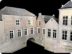
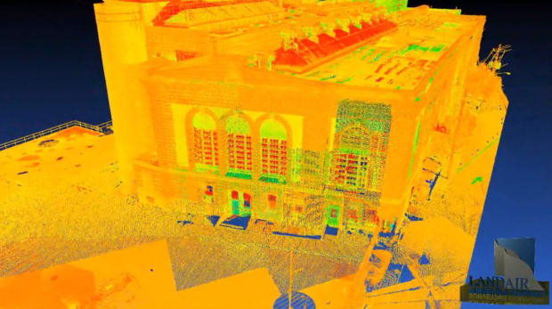
Building Information Modeling or BIM offers several advantages in the areas of building remodeling, construction planning, land surveying, and more. The technology involves collecting three-dimensional data to generate digital representations of a structure or property. The information is managed in its digital form and makes it easier to collaborate between all parties working on a project.

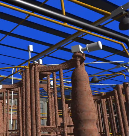
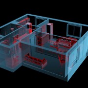
With this information it is a simple task to generate models that properly convey the physical as well as functional characteristics of any location. BIM offers a method for achieving intelligent model-based processes during the planning, design, construction, and maintenance phases of a structure or location. It is used by civil engineers, Architects, Structural Engineers and MEP engineers, to provide accurate designs to architects and additional individuals working on a development project.

Engineering professionals are beginning to see the many benefits of BIM for in engineering, as the technology becomes a standard application. Engineers are often asked if they are “BIM ready”. For them, there is an uncertainty on how this process applies to their design contributions. The most noticeable benefits are improved plans, enhanced efficiency, and a higher rate of productivity.

How Does BIM Benefit Civil Engineers?

BIM for engineers links the design, architectural, and construction documentation together to deliver better decision making abilities. When BIM is used for every portion of the data collection process, each involved party gains a complete picture. It allows for alternatives to be considered, makes it easier to facilitate design changes, and provides reliable construction documentation in less time. Development projects using BIM provide a great foundation for accomplishing the following tasks:

1. Visualizing the Project
2. Simulating Building Scenarios
3. Analyzing Design Elements
4. Identifying Design Conflicts
5. Improving Material Estimates
6. Managing Development Expenses
7. Making Better Informed Decisions

BIM for engineers make it easier to incorporate code compliance within the design and prevents problems such as delayed schedules or extensive change orders. Further analysis should also be performed to verify potential dangers of a structure or property prior to starting construction.

How BIM Helps Teams

When you work with a team of individuals, everyone will have the same data and information. Data collected for BIM is linked within a database, which is accessible by each person on the development team. The collection process often begins with the initial land or building surveying tasks. This information is then used to create a 3d model of the property, proposed structure, or an existing building. In the end, using BIM makes it easier to create the initial layout of a structure, roadway, or another property feature.

This information is then used to add features to the generated 3d model to meet the specific needs of any client. 3d models provide a communication bridge where it is easier to collaborate on the initial design, view potential changes, and manage the physical construction. Building information modeling helps team members to visualize the design elements and incorporate needs throughout the process. At LandAir Surveying, we use the latest advanced technologies for collecting BIM data. This ensures you have dependable, accurate information for generating a manageable model for any project.

3d-laser-scanning-technology

3D Laser Scanning Technology: What Are the Benefits?

3d-laser-scanning-technologyMany beneficial technologies have emerged to aid in processes such as surveying, architectural design, and land or property evaluation. Among these options, 3D Laser Scanning Technology is used in several ways to help with the design and construction of buildings as well as for gaining survey information about a location. 3D Laser Scanning Technology makes it possible to provide real, life-like images of a piece of land, location, or existing building to make well-informed calculations and designs.

High speed 3d scanners are used to capture 3D images and data in real-time to provide accurate models of an area prior to or post construction. The approach is used in a number of industries including:

  • Architecture
  • Transportation
  • Logistics
  • Aviation
  • Building Construction
  • Bridge Design
  • Water and Waste water plants

The type of 3D Laser Scanning Technology used depends on the industry as well as defined needs. For example, in architecture, 3D laser scans are used to superimpose a building image on a landscape with precise specifications to show what the finished project will look like. This is just one of the many applications of 3D Laser Scanning Technology.

How is 3D Laser Scanning Technology Used in Surveying

In surveying, laser scanning is used to document existing conditions in order to plan a project and create the initial design. It allows all the designers to see exactly what the actual conditions of the selected site look like in full 3D.

The results may be reviewed on a computer and incorporated into a 3D model at any time without requiring another site visit. Surveying companies gain these benefits with 3D Laser Scanning Technology:

  • Decreased Field Time
  • Increased Visibility and Understanding
  • Accurate Spatial Reconstruction
  • Higher Precision Data

So how do these benefits transfer to you the client when hiring a surveying provider? First, you gain highly accurate data that can be manipulated and applied to schematics or other processes via a computer. This takes less time and provides more accurate results when designing a building, planning construction for a site, or taking on a rennovation project. The scan delivers an accurate depiction of an area in as-is condition so the data may be applied accordingly in models. Additionally, clients can expect the following benefits:

  • Lower Overall Risk
  • Reduced Rework
  • Decreased Project Costs
  • Capture Existing Conditions in High Resolution
  • Fewer Physical Site Visits
  • Better Information Management During a Project

At LandAir Surveying we know how important it is to get the right data for successful project completion. Whether you need to verify the topology of a location or require building measurements for remodeling, we offer the use of 3D Laser Scanning Technology to deliver accurate, realistic data you can use throughout the development process. Contact us today to learn more!

building-renovations

Why Survey Before a Building Renovation?

If you are in process of or getting ready to perform a building renovation, then complete asbuilt information is necessary to ensure the job is done right the first time. This type of project requires specific information about the structure in order to make the best decisions. For example, without knowledge of the systems within a building, it will be hard to know what locations are safe to renovate. Before ever starting a building renovation, it is essential to know where primary systems are located, where enhancements should be made to meet code requirements, and the condition of any deteriorated components.

You may need further information if HVAC openings are necessary or features such as elevators will be added. It is the job of the surveying provider to obtain the measurements and details needed for these decisions. They provide the asbuilt information designers use to make important building renovation decisions. You need precise and current information to give the designers and construction professionals the information they need for a quality renovation.

How Does the Initial Survey Help?
This information provides a base set of data for making the most cost effective decisions regarding a building renovation. If Building Information Modeling (BIM) is used to depict the structures current state, then designers and construction professionals have every element necessary to safely complete the project. Design professionals must have accurate structural plans, which are impossible to provide without knowing the measurements and locations of important building components.

Surveyors initially record the boundaries in addition to the current state of the entire property. This often includes the physical locations of structures and the measurements of each structure. If they used advanced technology such as Laser Scanners it will provide a digital model of the existing structure that may then be used to coordinate design and construction efforts as the project takes place. When you are planning a building renovation, initial surveying offers several benefits including:

  • Accurate Measurements
  • Boundary Identification
  • Location of Physical Structures
  • Internal Element Modeling
  • Lower Renovation Costs
  • Increased Margin for Error
  • Decreased Waste
  • Better Project Estimates
  • Improved Design Characteristics

An initial survey functions as a blueprint for making safe, beneficial changes to any existing structure. In the end, it will increase the accuracy of the designer’s recommendations as well as decrease the cost required to complete the renovation. It also allows each involved party to coordinate their efforts for improved decision-making and better management of the entire project.

In the end the as-build survey will be accurate and every change can be made safely at the lowest possible cost. At LandAir Surveying, we use the latest technologies including BIM to provide the most accurate depiction of an area or structure. With this advanced technology, you gain a digital model for improved accuracy and collaboration throughout building renovation. Contact us today to learn about how BIM and other surveying technologies are able to aid with your latest renovation project.

BIM-architects

BIM for Architects: An Effective Way to Enhance Creativity

The technology used to map and create Architectural asbuilt has significantly changed. This is largely due to several advancements in how the data is captured for use during design and construction. Building Information Modeling or BIM for architects delivers reliable digital models that may be used to make help the designer make better decisions. A digital model based on accurate measurements allows architects to have a solid depiction of what the structure or facility will look like prior to construction. BIM for architects provides the ability to reduce:

  • Errors
  • Waste
  • Costs
  • Time

Besides having the information necessary reduce time, errors and cost, BIM technology also delivers collaboration advantages, as team members are able to easily share information and alter data to determine what will work best for the project. This modeling approach provides an easier way to define building functionality as well as physical characteristics. The technology helps professionals to create a better design in the earliest phase of a project, gain a better understanding of real world costs, and have accurate, digital documentation.

What Areas Experience the Most Benefits?
BIM’s defines the margin of error while providing the ability to make faster, cost effective design decisions. The modeling technology and rich point clouds aids in choosing what components the building requires, determining material quantities, and in assessing resource needs. Additionally, BIM for architects offers the most precise data for building construction, which was previously not part of modeling tools. BIM goes far beyond aiding in structural elements such as fixture locations or the area of a space. This modeling technology provides assistance in these among other areas:

  1. Calculations – BIM takes into account spatial relationships, lighting analysis, and other factors to portray a buildings entire lifespan. This aids in improving the measurements and calculations required to complete the design.
  1. Sustainability – Having the ability to assess a structure’s sustainability provides a better idea of how it will impact the environment and what waste will be generated as construction takes place.
  1. Engineering Integration – BIM for architects and engineers allows the structural aspects to be integrated with the design concepts faster. This technology may be linked with analysis tools to deliver superior accuracy while limiting errors during coordination.

The benefits above show an obvious advantage to using BIM’s to design and model a structure. If the technology is used to survey an area, this information is then given to the architect to provide a more accurate depiction of the building foundation. From this data, the architect can then easily design a structure and see exactly how it will look at the location long before breaking ground. BIM for architects ensures that every aspect of this process is accurate and provides the ability to network with each involved party for improved planning.

While the above benefits are all great reasons to begin using BIM for structural planning, it also provides professionals with the ability to be more creative due to digital form and data accuracy. At LandAir Surveying, we use BIM technology to capture the current state of a location or structure. With this precise documentation this information may then be used to produce a creative design with absolute accuracy to ensure the success of any project.

Contact us today to get started!


BIM-Services

BIM Services: Fortifying the Design and Building Process

Building Information Modeling or BIM services are provided to manage the physical and functional characteristics of a location or structure in digital form. Generated models may be shared to improve the decision-making process for all involved parties. BIM services have proven to be useful in these areas:

  • Planning
  • Design
  • Construction
  • Operations
  • Maintenance

These models are an excellent resource for mapping out structures and large diverse physical infrastructures like wastewater facilities or sports arenas. BIM services essentially provide a 3D digital blue print of a structure or area that serves as an aid in every aspect of the above activities.

Why Use Advanced Modeling Methods?
Traditional practices involve the creation of two-dimensional drawings, which take more time and have a greater margin for error. They require multiple visits to the site or structure to gain the needed asbuilt documentation. 3D BIM services offer advanced modeling benefits beyond geometric features to deliver reliable information about:

  • Spatial Relationships
  • Light Analysis
  • Geographic Information
  • Quantities
  • Building Component Properties

Laser Scanning is useful in a number of areas because it provides information in less time with higher accuracy. These models aid in areas such as building design and construction because they provide the data all parties need to make informed decisions. BIM services provide a complete digital view of any area or facility to deliver reliable data that may be manipulated or used without multiple visits to the physical location.

What Are the Benefits?
The most obvious benefit of BIM services is faster acquisition of precise data for decision-making processes. However, these digital models also allow the facility manager to gain dependable modeling data for improved operations and maintenance practices. On average, three fourths of associated costs for a facility occur after it has been completed and begins operations. BIM services provide accurate data to lower these costs as a structure or area must be maintained. Additional benefits offered by BIM include:

  • Improved Design Coordination
  • Better Construction Practices
  • Fast, Accurate Modeling
  • Less Site Visits
  • Lower Costs
  • Error & Omission Reductions
  • Better Collaboration
  • Reduced Rework
  • Project Duration Decreases

With 3D BIM services, you gain the ability to better allocate and reduce the number of resources needed for a project. It also reduces the cost overruns and rework budget. By offering a complete data set measureable in 3D project outcomes improve greatly.

The process goes beyond traditional 2D or 3D resources by delivering a data repository consisting of the design, building, and maintenance information in one convenient model. This model may then be shared with stakeholders to ensure every involved process is beneficial to the project. BIM services deliver change management, data leveraging, and task administration advantages as well. At LandAir Surveying, we offer BIM services to our clients to save both time and money while gaining the most reliable information for a project. The capturing process not only takes less time to complete, but also delivers accurate, reliable data. Contact us today to see how our BIM services are able to help with any current or future project.

BIM-Se

3d Laser Mapping: Using Technology to Gain Accurate Measurements

3d-laser-mappingIf you have recently considered using a survey company or are currently aligning with one, the term 3d laser mapping might have been mentioned. This process involves the use of a 3d laser scanner when surveying a structure or environment to capture extensive points of data about the area in a short amount of time. The scanner uses laser light technology to capture the data at a faster rate. 3d laser mapping offers greater efficiency over the traditional approach of visiting the building each time to take a measurement to know the actual dimensions.

As opposed to traditional methods, 3d laser mapping provides dependable, accurate measurements in less time. A scan offers all the necessary data in the form of a digital record for easy collaboration and fast access. For example, if you need to know the number of light fixtures within a structure, all you have to do is look at 3d laser mapping data. If additional members of your team need to see this information all you have to do is share the point cloud created during the scan. 3d laser mapping provides a faster, easier way to obtain accurate information for any area by using advanced technology to collect and store it in a digital format.

How Does The Technology Work and What Are the Benefits?
A 3d scanner rotates in a circle to capture the data regarding everything it sees within the mapping area. Similar to the workings of a camera, they may be set up rather quickly to do multiple scans of a structure or area. Every scan involves collecting a vast number of data points, which are combined to deliver a digital image of the surveyed site, building, or area. 3d laser mapping is used to capture a buildings current state including every nuance.

This technology is used to analyze any object or location to collect specific data regarding its shape or appearance. The information is then utilized to render 3d models for these among other areas:

  • Surveying
  • Building Construction
  • Industrial Design
  • Reverse Engineering
  • Prototyping
  • Quality Control

Most 3d laser mapping services will use varying tools depending on the type of scanning to be performed. In the end, more than one scan is performed to gain as much data as possible for accurate mapping and modeling. There are several benefits to using 3d laser mapping over traditional methods, but these are the most notable:

  • Reduced Time
  • Increased Accuracy
  • Process is Non-Intrusive
  • Information Stored Digitally

3d laser mapping allows you to have the answers to unknown questions before they even become apparent thus allowing for faster workflow. It provides an opportunity to optimize scheduling while at the same time keeping shutdown measures at a minimum. Use of 3d technology reduces errors, decreases the number of change orders, and limits waste. Since the measurements do not have to be taken by hand during multiple visits, the risk of injury is much less and this boosts safety for every involved party. At LandAir Surveying, we use 3d laser mapping to provide an accurate depiction of structures and environments to ensure the right information is gained for achieving your surveying and decision-making objectives. Contact us today!

BIM-Construction-Professionals

How Do Construction Professionals Use BIM?

BIM (Building Information Modeling) is a three-dimensional technology that combines the use of intelligent information with the modeling process to deliver accurate representations prior to, during, or post construction. It helps service providers to align objectives, as analysis, planning, and building take place. BIM offers advantages from the initial stages of planning including land surveying to gain detailed location information to analyze the property during construction planning. It also provides great insight for detecting interference and avoiding errors because providers are able to:

  • Communicate Better
  • Visualize the Process
  • Improve Layout Dimensioning
  • Use Progress Simulations
  • Maintain Lower Costs
  • Coordinate Involved Parties

BIM-ConstructionLarge projects flow better because the process delivers improved coordination between multiple teams ranging from design to operators. When combined with additional intelligence, providers are able to deliver enhanced results throughout the full life cycle of a property at a lower cost.

It creates a virtual design forum where each party can contribute information and detect issues from a simulated structure prior to ever breaking ground. This model is created by the design team and then provided to every contractor, owner, or operator. These individuals then add their own data to the shared model for complete accuracy and enhanced communication. With BIM, every stakeholder is able to view the information thus ensuring there are no scheduling clashes or design issues. BIM makes it easier to identify the problems early on so they are addressed within the simulated structure rather than the physical structure.

BIM Benefits Everyone
Information gathering starts during the initial land surveying to aid in the planning and analysis before design takes place. BIM offers great insight for assessing the physical characteristics of a property. This information is automatically included into the model as each party contributes additional data regarding components, processes, and design characteristics. The data may then be mined to identify project performance or any existing problems as well as to monitor the construction process as it takes place.

The technology is not limited to construction as it is applicable when designing or displaying the functional characteristics of a facility. To keep it simple, BIM is a digital representation for viewing the characteristics of a piece of property, project, or existing building. Three-dimensional modeling is applicable for these construction phases:

  • Surveying
  • Planning
  • Analysis
  • Design
  • Building
  • Operations

At the technical core, it delivers improved information management through the use of intelligent models; however, it also boosts project coordination and collaboration between each player. It is a better approach than each involved party obtaining information from another provider who is higher on the chain for completing a project thus creating gaps in the process.

BIM provides a dependable, collaborative environment where 3D models may be used to input data and coordinate every portion of the construction process from one central database of information. Now each contributor has access to accurate information combined with accurate simulations for better analysis and decision-making as a project progresses. At LandAir Surveying, we use 3D technology to provide our clients with a better understanding of a location’s physical properties to ensure the proper path for project success. Contact us today to learn more!

High Definition Surveying: What Is It?

HighDefinition SurveyingHigh Definition Surveying (HDS) or 3D Laser Scanning is a now an industry standard for small or large development projects. Several technology advancements have made this approach one of the best ways to keep a project moving smoothly and costs low. This is because high definition surveying helps managers gain precision data faster for incorporation into the modeling process. With this approach, a narrowed beam consisting of pulsed laser light is deployed across the target area to record an extensive amount of measurements at the same time.

The measurements are then shown on a computer screen in what is called a point cloud. It is similar to a three-dimensional model; however, the scan locations are actually combined into the point cloud for use in various types of design and development services. Point clouds are used in these among other endeavors:

  • Virtual Walkthroughs
  • Detecting Interference
  • Containment Analysis
  • Building of 3D Interactive Models
  • Demolition or Critical Move Plans
  • Inventory Management

High definition surveying delivers a non-intrusive method of rapidly collecting data about a location. This type of surveying is applicable in a number of areas ranging from construction to design planning. It delivers accurate, economical details about a location or structure with an advanced level of detail over alternative surveying methods. The created models may easily be viewed and modified on a computer. This allows the data to be incorporated into other modeling technologies used in this field for improved analysis and design.

What Advantages Does High Definition Surveying Offer?
Many advantages may be gained from using high definition surveying as the collected data ensures fast analysis as well as application during computer-aided design or building information modeling. Among these benefits is the ability to visualize the area to determine where building should take place and identify safety concerns. For example, having a model of a terrain aids in determining the best location for a structure without the need for alterations. This allows all involved parties to make decisions faster and with far more accuracy.

The primary benefits of HDS are faster data collection with exceptional accuracy for reliable analysis and modeling. HDS makes it easier to collect the information with less effort as a two person crew is able to scan as much as ten acres in one day whereas conventional methods require a larger crew and cover less acreage. By using HDS, the costs of a survey are significantly lower for any sized project. The surveying process aids in several design and building project areas including the development of:

  • Site or Floor Plans
  • Building Information Models
  • Digital Terrain Models
  • Foundation Plans
  • Electrical Plant Layouts
  • Space & Asset Inventories
  • Structural Plans

High definition surveying reduces need for further site visits because the scan is performed once for data input. It is not necessary to return to the site to take further measurements. The technology offers a low cost, reliable approach to change detection, hazard surveying, accident reconstruction, as-built assessments, and construction projects. At LandAir Surveying, we use HDS to deliver accurate, fast terrain data. Contact us to learn how high definition surveying may be used to ensure the success of your latest development project.

Building-Mapping

What Is The Purpose Behind Building Mapping?

Building mapping is a type of survey performed by professionals to identify the location of each constructed element of a structure to gain measurements or produce plans. These processes are typically required prior to renovating a building or at some point during construction. Building mapping technology captures the current state of a building or facility. In some cases, it is an applicable approach to modeling an entire city in order to recreate it in a computer-generated model. This is beneficial for evaluating a cities current topography for renovations and has even been used to generate locations in video games based off a real place.

Building mapping involves gathering precise measurements to display an accurate projection of its internal or external structure. One example of this would be the creation of a floor plan based on the existing state of a building to display fixtures, pipes, doors, windows, and dimensions. The process is frequently used to survey a property and generate a floor plan or model for:

  • Upcoming Renovations
  • Historical Preservation
  • Surveying Older Buildings
  • Unconventional Construction Projects
  • Structural Changes
  • Post Renovation or Construction asbuilts documents

Traditional methods involve the surveyor taking a physical walkthrough of the property to gain measurements and map it out. However, new technologies such as three-dimensional scanning and modeling have made this process not only easier, but also far more reliable. These technologies provide faster results by automatically collecting essential data for building information modeling or computer-aided design to provide an accurate structure model for managing the project.

Why is Building Mapping Important?
Building mapping provides pertinent data for anyone who wants to make changes or needs to map out routes to support emergency planning. For example, if you want to renovate a building, knowing the location of piping within the structure ensures nothing is busted or harmed during the change. It also helps builders determine where fixtures should go or new supported piping should be placed. The same applies to electrical changes, room additions, and assessing the progress of a structure as it is built.

A combination of physical surveying and scanning technology is often used to gather information about a structure based on mathematics and dimensions. This information is then applied within a specialized computer application to generate:

  • Evacuation Maps
  • School Security Maps
  • Interactive Structure Information
  • Renovation Plans
  • Campus Maps
  • Floor Plans
  • Piping or Fixture Layouts
  • Structure Age or Sizing Measurements

Building mapping is a beneficial process when you want to acquire data to input into 3D modeling programs. Several methods are applicable for acquiring this data including Building Information Modeling or BMI. 3D laser scanning is often used to acquire the data needed for BMI, which may then be built upon throughout the renovation or construction process to avoid errors or setbacks and maintain costs. Additionally, it allows companies to identify any existing safety hazards to eliminate the chance of injury within a structure. At LandAir Surveying, we use the latest technology to complete building mapping. Whether it is an old building, an unconventional structure, or you simply need a floor plan, we can help you identify every aspect of the building for guaranteed project success.

Benefits of BIM for Surveying, Design, and Construction

Historic renovation Plant to Hotel from LandAir Surveying on Vimeo.

BIM or Building Information Modeling involves the generation of 3D digital representations of the physical or functional characteristics for an existing enviroment. BIM technology allows designers to easily collaborate during the decision making process of a building process. The information is beneficial to many design professionals involved collectively in the same project.

  • Planning
  • Design
  • Construction
  • Operation
  • Maintenance

A number of highly diverse infrastructures frequently use BIM including wastewater management facilities, electrical plants, oil & gas facilities, communication utilities, roads, bridges, houses, and schools. BIM helps those in the field of construction envision a project before it is started to eliminate uncertainty, work out problems prior to building, and analyze potential risks.

How Does BIM Help?
BIM is an alternative option to the traditional Computer-Aided Design (CAD) strategies because it offers a number of advantages over traditional methods such as the ability to graphically show information for design and development andit is easily distributable to many different team members collectively. To truly understand the difference, the first thing to remember is that BIM is not simply a technology, but rather a process used to support the design, construction, or management of a design or renovation project.

The technology itself is available on several different platforms, which support both architectural tools and incorporate information intelligence as part of the modeling process. BIM often consists of several layers spanning these areas:

  • Model & Object Creation
  • 3D Asbuilt information of existing conditions
  • 3D Models of esisting and proposed enviroments
  • Ability to clash the new design with the old to identify difficult areas

Each level of implementation provides the ability to share information between individuals for improved planning and development. Three-dimensional, dynamic modeling is used to boost productivity as well as have a better understanding of these items: building geometry, spatial relationships, component properties and geographical data. This approach to 3D modeling delivers several benefits for achieving a solid design for the complete building data lifecycle.

What Are The Advantages?
BIM is more than just a modeling process, providers are able to use gathered information to make intelligence driven decisions throughout every phase of development. This prevents the need for rework, as the physical structures are implemented onsite. Additionally, this aids in limiting the number of conflicts or changes that arise during actual building or implementation thus decreasing costs. The benefits of BIM go beyond simple modeling to include:

  • Better Visualization
  • Heightened Productivity
  • Improved Document Coordination
  • Information Linking Between Contributors
  • Faster Delivery Time
  • Lower Costs
  • Shortened Approval Cycles
  • Reduced Project Duration
  • Predictability & Better Control

At LandAir Surveying, we have been providing high quality services for more than forty years. This includes vast experience in areas such as 3D laser scanning. We will help you gain a complete view of your property by using three-dimensional technology to boost the intelligence offered by BIM.