building-renovations

Why Survey Before a Building Renovation?

If you are in process of or getting ready to perform a building renovation, then complete asbuilt information is necessary to ensure the job is done right the first time. This type of project requires specific information about the structure in order to make the best decisions. For example, without knowledge of the systems within a building, it will be hard to know what locations are safe to renovate. Before ever starting a building renovation, it is essential to know where primary systems are located, where enhancements should be made to meet code requirements, and the condition of any deteriorated components.

You may need further information if HVAC openings are necessary or features such as elevators will be added. It is the job of the surveying provider to obtain the measurements and details needed for these decisions. They provide the asbuilt information designers use to make important building renovation decisions. You need precise and current information to give the designers and construction professionals the information they need for a quality renovation.

How Does the Initial Survey Help?
This information provides a base set of data for making the most cost effective decisions regarding a building renovation. If Building Information Modeling (BIM) is used to depict the structures current state, then designers and construction professionals have every element necessary to safely complete the project. Design professionals must have accurate structural plans, which are impossible to provide without knowing the measurements and locations of important building components.

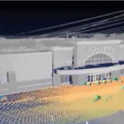
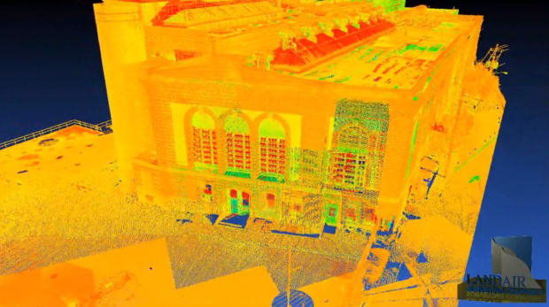
Surveyors initially record the boundaries in addition to the current state of the entire property. This often includes the physical locations of structures and the measurements of each structure. If they used advanced technology such as Laser Scanners it will provide a digital model of the existing structure that may then be used to coordinate design and construction efforts as the project takes place. When you are planning a building renovation, initial surveying offers several benefits including:

  • Accurate Measurements
  • Boundary Identification
  • Location of Physical Structures
  • Internal Element Modeling
  • Lower Renovation Costs
  • Increased Margin for Error
  • Decreased Waste
  • Better Project Estimates
  • Improved Design Characteristics

An initial survey functions as a blueprint for making safe, beneficial changes to any existing structure. In the end, it will increase the accuracy of the designer’s recommendations as well as decrease the cost required to complete the renovation. It also allows each involved party to coordinate their efforts for improved decision-making and better management of the entire project.

In the end the as-build survey will be accurate and every change can be made safely at the lowest possible cost. At LandAir Surveying, we use the latest technologies including BIM to provide the most accurate depiction of an area or structure. With this advanced technology, you gain a digital model for improved accuracy and collaboration throughout building renovation. Contact us today to learn about how BIM and other surveying technologies are able to aid with your latest renovation project.

BIM-architects

BIM for Architects: An Effective Way to Enhance Creativity

The technology used to map and create Architectural asbuilt has significantly changed. This is largely due to several advancements in how the data is captured for use during design and construction. Building Information Modeling or BIM for architects delivers reliable digital models that may be used to make help the designer make better decisions. A digital model based on accurate measurements allows architects to have a solid depiction of what the structure or facility will look like prior to construction. BIM for architects provides the ability to reduce:

  • Errors
  • Waste
  • Costs
  • Time

Besides having the information necessary reduce time, errors and cost, BIM technology also delivers collaboration advantages, as team members are able to easily share information and alter data to determine what will work best for the project. This modeling approach provides an easier way to define building functionality as well as physical characteristics. The technology helps professionals to create a better design in the earliest phase of a project, gain a better understanding of real world costs, and have accurate, digital documentation.

What Areas Experience the Most Benefits?
BIM’s defines the margin of error while providing the ability to make faster, cost effective design decisions. The modeling technology and rich point clouds aids in choosing what components the building requires, determining material quantities, and in assessing resource needs. Additionally, BIM for architects offers the most precise data for building construction, which was previously not part of modeling tools. BIM goes far beyond aiding in structural elements such as fixture locations or the area of a space. This modeling technology provides assistance in these among other areas:

  1. Calculations – BIM takes into account spatial relationships, lighting analysis, and other factors to portray a buildings entire lifespan. This aids in improving the measurements and calculations required to complete the design.
  1. Sustainability – Having the ability to assess a structure’s sustainability provides a better idea of how it will impact the environment and what waste will be generated as construction takes place.
  1. Engineering Integration – BIM for architects and engineers allows the structural aspects to be integrated with the design concepts faster. This technology may be linked with analysis tools to deliver superior accuracy while limiting errors during coordination.

The benefits above show an obvious advantage to using BIM’s to design and model a structure. If the technology is used to survey an area, this information is then given to the architect to provide a more accurate depiction of the building foundation. From this data, the architect can then easily design a structure and see exactly how it will look at the location long before breaking ground. BIM for architects ensures that every aspect of this process is accurate and provides the ability to network with each involved party for improved planning.

While the above benefits are all great reasons to begin using BIM for structural planning, it also provides professionals with the ability to be more creative due to digital form and data accuracy. At LandAir Surveying, we use BIM technology to capture the current state of a location or structure. With this precise documentation this information may then be used to produce a creative design with absolute accuracy to ensure the success of any project.

Contact us today to get started!


BIM-Services

BIM Services: Fortifying the Design and Building Process

Building Information Modeling or BIM services are provided to manage the physical and functional characteristics of a location or structure in digital form. Generated models may be shared to improve the decision-making process for all involved parties. BIM services have proven to be useful in these areas:

  • Planning
  • Design
  • Construction
  • Operations
  • Maintenance

These models are an excellent resource for mapping out structures and large diverse physical infrastructures like wastewater facilities or sports arenas. BIM services essentially provide a 3D digital blue print of a structure or area that serves as an aid in every aspect of the above activities.

Why Use Advanced Modeling Methods?
Traditional practices involve the creation of two-dimensional drawings, which take more time and have a greater margin for error. They require multiple visits to the site or structure to gain the needed asbuilt documentation. 3D BIM services offer advanced modeling benefits beyond geometric features to deliver reliable information about:

  • Spatial Relationships
  • Light Analysis
  • Geographic Information
  • Quantities
  • Building Component Properties

Laser Scanning is useful in a number of areas because it provides information in less time with higher accuracy. These models aid in areas such as building design and construction because they provide the data all parties need to make informed decisions. BIM services provide a complete digital view of any area or facility to deliver reliable data that may be manipulated or used without multiple visits to the physical location.

What Are the Benefits?
The most obvious benefit of BIM services is faster acquisition of precise data for decision-making processes. However, these digital models also allow the facility manager to gain dependable modeling data for improved operations and maintenance practices. On average, three fourths of associated costs for a facility occur after it has been completed and begins operations. BIM services provide accurate data to lower these costs as a structure or area must be maintained. Additional benefits offered by BIM include:

  • Improved Design Coordination
  • Better Construction Practices
  • Fast, Accurate Modeling
  • Less Site Visits
  • Lower Costs
  • Error & Omission Reductions
  • Better Collaboration
  • Reduced Rework
  • Project Duration Decreases

With 3D BIM services, you gain the ability to better allocate and reduce the number of resources needed for a project. It also reduces the cost overruns and rework budget. By offering a complete data set measureable in 3D project outcomes improve greatly.

The process goes beyond traditional 2D or 3D resources by delivering a data repository consisting of the design, building, and maintenance information in one convenient model. This model may then be shared with stakeholders to ensure every involved process is beneficial to the project. BIM services deliver change management, data leveraging, and task administration advantages as well. At LandAir Surveying, we offer BIM services to our clients to save both time and money while gaining the most reliable information for a project. The capturing process not only takes less time to complete, but also delivers accurate, reliable data. Contact us today to see how our BIM services are able to help with any current or future project.

BIM-Se

3d Laser Mapping: Using Technology to Gain Accurate Measurements

3d-laser-mappingIf you have recently considered using a survey company or are currently aligning with one, the term 3d laser mapping might have been mentioned. This process involves the use of a 3d laser scanner when surveying a structure or environment to capture extensive points of data about the area in a short amount of time. The scanner uses laser light technology to capture the data at a faster rate. 3d laser mapping offers greater efficiency over the traditional approach of visiting the building each time to take a measurement to know the actual dimensions.

As opposed to traditional methods, 3d laser mapping provides dependable, accurate measurements in less time. A scan offers all the necessary data in the form of a digital record for easy collaboration and fast access. For example, if you need to know the number of light fixtures within a structure, all you have to do is look at 3d laser mapping data. If additional members of your team need to see this information all you have to do is share the point cloud created during the scan. 3d laser mapping provides a faster, easier way to obtain accurate information for any area by using advanced technology to collect and store it in a digital format.

How Does The Technology Work and What Are the Benefits?
A 3d scanner rotates in a circle to capture the data regarding everything it sees within the mapping area. Similar to the workings of a camera, they may be set up rather quickly to do multiple scans of a structure or area. Every scan involves collecting a vast number of data points, which are combined to deliver a digital image of the surveyed site, building, or area. 3d laser mapping is used to capture a buildings current state including every nuance.

This technology is used to analyze any object or location to collect specific data regarding its shape or appearance. The information is then utilized to render 3d models for these among other areas:

  • Surveying
  • Building Construction
  • Industrial Design
  • Reverse Engineering
  • Prototyping
  • Quality Control

Most 3d laser mapping services will use varying tools depending on the type of scanning to be performed. In the end, more than one scan is performed to gain as much data as possible for accurate mapping and modeling. There are several benefits to using 3d laser mapping over traditional methods, but these are the most notable:

  • Reduced Time
  • Increased Accuracy
  • Process is Non-Intrusive
  • Information Stored Digitally

3d laser mapping allows you to have the answers to unknown questions before they even become apparent thus allowing for faster workflow. It provides an opportunity to optimize scheduling while at the same time keeping shutdown measures at a minimum. Use of 3d technology reduces errors, decreases the number of change orders, and limits waste. Since the measurements do not have to be taken by hand during multiple visits, the risk of injury is much less and this boosts safety for every involved party. At LandAir Surveying, we use 3d laser mapping to provide an accurate depiction of structures and environments to ensure the right information is gained for achieving your surveying and decision-making objectives. Contact us today!

So I have a 3D Laser Scanner – now what?

There is a common misconception that 3D laser scanning is a one-size-fits-all solution for every project. The truth is, this new technology is powerful – but it’s not for every surveying firm and it’s not a fit for every project.

First, surveying with a scanner is not the same as with a total station or GPS. For one, there are no field notes – just lots of data points and photographic files.

Another important distinction is the line of site requirement. When a survey crew sets up a survey instrument, they are typically looking for a line of site to the next point. That’s not the case with a scanner, which requires a more focused coverage. Some setups may only be 15 feet from the last if you need to get more views of a complicated structure.

With laser scanning, it is common to gather data that the client does not need at the time, but may need to use later. Once a site is scanned and post-processed, engineers and analysts can check and re-check engineering quality data on a desktop computer any time.

Computer power plays a significant role in successful laser scanning. The post-processing of laser scanned data is critical and can be tedious on older computers. Before buying into scanning technology, invest in at least 64-bit machines with fast graphics cards and as much RAM memory as possible.

You may want one computer to process the scan data and another to process the photographic data. Laser scanners create enormous files that must be managed carefully in a consistent workflow. (Our exterior projects normally have 1 to 10 gigabytes of data and a major industrial facility can have over 150 gigabytes of data.) Create to processes and work flows to store and back up everything.

Finally, don’t expect clients to beat down your door, demanding a 3D laser scan. Buying a scanner won’t make jobs magically appear. The market is just learning about this technology and though it is well worth the investment for those firms willing to do the legwork to find the clients who want and need its special capabilities, you will have to do a lot of educating and demonstrations of what the world of 3D can bring to clients.

The key is listening to your clients and understanding their needs. Keep in mind that many potential clients don’t know what questions to ask. Until laser scanning becomes as common as GPS, surveyors will have to educate owners, architects, engineers and contractors about the benefits.

###

Tate Jones has over 40 years of experience in land and aerial surveying and was one of the country’s earliest adopters of 3D laser scanning technology. A nationally recognized expert in the field of 3D data capture, he has worked with hundreds of clients in the engineering, architectural and construction industries. Contact him at tjones@lasurveying.com. To learn more about 3D laser surveys, visit www.3DLaserSurveys.com.