First, let me say Happy New Year to all of our clients who have supported us for the past 25 years. We appreciate you and are honored that you choose LandAir Surveying to team with you on many interesting projects across America.
Over the past seven years of traveling down the road of 3D data capture and using multiple platforms for LiDAR data collection, we have seen this technology expand into almost every field of design, construction and manufacturing.
It has been fascinating to watch the world change from 2D plans to 3D data sets and models. And in the process, modeling is becoming cheaper, faster and easier.
Having attended international conferences and through speaking to groups across the country, we have seen and studied with interest what is going on in the U.S., Europe, Japan, India and Asia. The whole world of design and construction is making this shift!
Daily, we talk with firms both domestically and internationally about the diverse issues of 3D design and construction to equip us with the knowledge we need to be your trusted resource for new approaches to surveying projects.
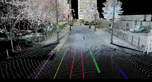
For example, we have been producing surveys for the transportation industry since 1998. I can remember when we had to actually put our surveyors out in traffic (with approved safety measures, of course). Now, with our scanners, we can stay off the shoulder of the road and capture all the required data without putting anyone in harm’s way. This is standard practice now and, as an owner of a surveying company, very important to me personally.
Approaches to projects are changing not only in transportation, but across all industries.
Last year, we produced a 400-acre topographic map with 1-inch contours in very, very dense foliage. Just two years ago, we would have had to field survey this project. But by using a combination of aerial LiDAR and strategic surveying techniques, we were able to produce the job at 1/3 the cost of a traditional field run survey.
In 2013, we plan to expand our technology, using drones to capture data on specific projects. This is already being done across the country and the technology is moving from military grade and unaffordable to civilian grade and absolutely affordable.
So, how can we help you this year? For one, we can show you how surveying tools are changing and getting better. We can discuss with you when to use airborne LiDAR to document and produce data over a city, county or state.
We can show you when the conditions are right to use mobile LiDAR and put together a team to make your project successful.
We know when to use helicopter platforms for LiDAR over fixed wing aircraft, and we can show you how to model the inside of an existing building faster and more cost effectively than ever before.
We look forward to being a valuable resource for your firm and hope to continue working with you in 2013 and beyond. The design world is changing very fast and we are committed to changing right along with it.
Have a great and profitable 2013!
###
Tate Jones has over 40 years of experience in land and aerial surveying and was one of the country’s earliest adopters of 3D laser scanning technology. A nationally recognized expert in the field of 3D data capture, he has worked with hundreds of clients in the engineering, architectural and construction industries. Contact him at tjones@lasurveying.com or visit www.landairsurveying.com.