Posts

Where we are now…and where we’re going.

As 2012 winds down and we get ready to head to Las Vegas for the Autodesk University conference, I look back at the strides that have been made in the 3D world and all of the associated hardware and software in our industry.

Not only is there new technology being used and accepted, but the demand for more BIM products, users, and technologists has grown faster than ever. I have also watched with great interest the wave of corporate acceptance that was not there even three years ago.

There is still much ground to be broken, but wow – what a year!

New Software

Take software, for example. As I travel around America and talk to user groups and clients, the one thing I am always asked is when will it be easier to model point clouds into usable entities?

There is much research going on to solve this challenge. Though I have no commercial interest in this firm, I believe one of the ones to watch in this space is ClearEdge 3D. Their EdgeWise Plant software is pushing the barriers away for modeling point clouds.

Personally, I believe that within the next three years, this major barrier we face now will be a minor issue and point cloud use will continue to grow and expand.

The other great leap in technology is that most of the major software packages have updated their products to accept point clouds as a layer. This means that most of our clients in the architectural and MEP worlds can now import our point clouds into their design software and greatly enhance their designs.

Just three or four years ago, using point cloud data required modeling and this limited the market to mechanical and structural engineers and various contractors with specialty software.

Today, because all Revit users can import point cloud data, the need to model everything in a scan project has been greatly decreased. This is a big deal! Now, instead of having to pay for an expensive model, end users get all of the benefits of point cloud precision without the associated costs of modeling.

Not to be overlooked, there are still issues that will need to be ironed out in inserting point clouds into design software, but they will be overcome with time.

For example, if you are working in Inventor to model plant process data, it is best if the project is modeled from start to finish in Inventor. Similarly, if it is to be modeled in Revit, it is best that it be modeled from start to finish in Revit. There are no readily available universal translators to move from a model that was created in Cyclone to a model in Revit while keeping the full integrity of the original model.

Though the data itself is globally transferrable, the structure of the models, entities, families and libraries requires more work to be done in this area.

New Hardware

Last year, I predicted that the hardware in our industry was set and that most of the changes would come in the form of software. On this point, I was wrong.

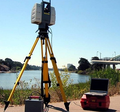
Several changes have occurred that continue to advance the hardware. For example, The Faro Focus 3D has broken the price barrier. Prior to its release, most scanners started around $80,000 and went up to $200,000. The Focus was released at about $50,000 and has caused price adjustments throughout the industry.

I believe this trend will continue and prices will continue to go down. This is both a good and bad thing for the industry. As prices go down, more people with marginal training and experience will begin to use scanners and bad point clouds will become more of a problem.

There is a saying in our industry that “one bad point cloud kills a lot of clients.” Indeed, this is true. I have talked to clients who tried laser scanning nine years ago, had a bad experience, and will not use it again to this day. The problem is not that scanners are getting more affordable, but that there are still no national standards in the industry.

The upside is that with a lower cost competitor, vendors must consider what value their laser scanners bring that others do not.

Cool New Technology

Two things I am really interested in and know will change the playing field moving forward are   aerial drones and augmented reality.

These two technologies are growing fast and have many great uses. A traditional helicopter used to map utilities and large areas generally costs about $25,000 per day. A one-meter drone quadripod, on the other hand, costs about $2,000 per day.

Though there are unique tasks that the smaller one-meter drones can do that the helicopter is currently doing, there are other tasks that the smaller drones can perform that traditional helicopters cannot do. For example, smaller drones can more effectively and safely map underground pipes, mines and tunnels.

Currently, to send two scanner technicians into a tunnel requires about six surface and sub-surface support staff. An unmanned drone with avoidance technology would be a great solution.

Augmented reality and the ability to project 3D images easily and to large groups is available and is changing the whole world of education. A small but growing company, ViziTech USA, is doing very creative and trendsetting work in this area.

This is where the science of 3D technology is repackaged so that the average person can use and understand it. This is a powerful tool and will lead to great changes in many industries and educational processes. For more on augmented reality, read our recent blog post here.

The design and construction of future projects will still require the same basic processes that are required today. But the use of precision data before, during and after construction – and the visual way the data can be viewed – will greatly reduce errors and downtime events.

###

Tate Jones has over 40 years of experience in land and aerial surveying and was one of the country’s earliest adopters of 3D laser scanning technology. A nationally recognized expert in the field of 3D data capture, he has worked with hundreds of clients in the engineering, architectural and construction industries. Contact him at tjones@lasurveying.com or visit www.landairsurveying.com.

 

The Next 3D Scanning Frontier: Transportation BIM and Augmented Reality

As I stand back and look at where 3D laser scanning has led us as a company, I am both pleased and confident that the world of 3D virtual design and engineering is healthy and growing fast.

I recently met some truly amazing people from all over America and Europe who are doing some very forward thinking things with 3D virtual reality in both transportation BIM systems and augmented reality. Here’s a snapshot of what I saw:

Transportation BIM Systems

I was in Washington, DC, a few weeks ago speaking at a large corporate meeting and had the opportunity to see a fascinating presentation on the San Francisco Bay Bridge construction.

The construction cost will come in around $7 billion (yes, billion). The metrics are staggering, but there are four major construction firms working on the project.

Cal Trans has scanner crews scanning the progress on a weekly basis. Because of this, there was room in the budget and the available technology to do real time clash detection of the existing and proposed construction.

Because the bridge was designed in 3D (really in 5D), engineers were able to save big bucks on relatively simple components. For example, the 3D scan allowed them to get real time views from the proposed security cameras underneath the bridge. As a result, the actual number of cameras was cut in half, saving several million dollars.

Crews also used 4D (time) clash detection to view when a new component of the bridge was being constructed while an existing component was still in place. The 4D BIM model, when clashed against the existing model at that moment in the construction sequence, showed that there were interferences in temporary construction items.

Though the clashes would not have interfered with the final design, they did interfere with the interim design and would have slowed construction. This knowledge allowed the designers and contractors to make modifications to the sequences before there was an actual problem.

Just a few years ago, this capability would have been unheard of!

One of the more astonishing things I saw was a 5D construction sequence video that showed the bridge’s proposed construction slide bar and dollars spent on overtime as the bridge was coming out of the ground or water. This enabled you to compare construction costs to the bridge’s progress. At this same time, the 3D graphic was color-coded to show the four separate contractors and their workflows.

This all sounds complicated – and it was – but through the 3D engineering process, you could view the time estimates, add the construction dollars, and come to a very natural conclusion as to what was actually taking place. You could confirm that one contractor had finished his new section before another section was tied into it.

A 3D video showing a major component – like how the cabling system would be threaded through the bridge to provide the final structural support – was also very intriguing to watch.

Augmented Reality

This may be one of the biggest and best changes that I foresee coming to the construction industry.

Augmented Reality (AR) is a live view of a real-world environment whose elements are augmented by computer generated sound, video, graphics or GPS data. If you consider that most new construction will first be built by engineers and designers in 3D in computers, then you may see where we are going with this.

With the base designed in 3D, you can then place a “target” in a construction zone. A target for augmented reality can really be anything as long as a tablet or cell phone can recognized it as graphic signal to launch 3D BIM programs.

These targets are used to orient the tablet to the exact same design point as where the construction is occurring on the ground. When targets are scanned with a tablet, the original design for that exact spot of construction is displayed. As the tablet is moved around this area, you can view the construction in 3D at a specific location.

Here’s an excellent example: Assume that you have a three-sided, multi-story concrete opening for a proposed staircase. By scanning the target placed in that area, construction workers can see on their iPad or Android tablet exactly what the finished product will look like. Not just a flat drawing on 600 sheets of blue lines, but the 3D model of how it will actually fit into the opening.

And remember: the world is international and these projects are under construction all over the world. By doing this, we just transcended the language barrier. We just solved the problem of expert tradesmen who are great at their craft but may not read details on blueprints that well. We just got a crew of 2-5 construction workers from a point of unknown to a point where everyone has a perfect mental picture of what is going to be constructed. That’s a huge step!

One of the oldest sayings for any worthwhile project is, “Begin with the end in mind.” What a great way of accomplishing this.

As a testimony to how well this is working, many construction companies have been rolling out flat screen computers onsite to show superintendents actual BIM models by sequence. All throughout the day, they are used over and over by the workers who are building bridges, buildings, and infrastructure around the world.

These rolling 3D models are helping to get projects constructed right the first time. They are preventing construction problems and saving big money. Very soon, I believe that all of this will be done with either special glasses or projection screens.

Currently, the only obstacle slowing the process is having a way to orient a 3D BIM model real time inside of a building. Outside, it can be done with GPS. But inside, it is more challenging.

However, augmented reality will very quickly make paper plans obsolete. I have seen it in too many places and have seen the benefits. It is coming and will soon be a standard. All of the major construction companies are embracing this technology.

Another real use of augmented reality will be in the operations of the finished building. The technology already exists to allow a maintenance worker to go up to a motor or valve (or any piece of equipment that has a target) and scan it with his tablet or phone.

This opens up a computer database so that he can see the last maintenance schedule and the internal parts of the machine. If he services the machine, his data is automatically sent to the company database and is available for anyone to review. Or, if a repair is needed, he can launch a video of how to take apart the machine and replace any part he needs.

This brings the power of the “owner’s manual” and the entire knowledge stored in the computers running the facility in real time 3D to the exact point it is needed. Imagine the implications if you own a complex manufacturing facility.

In just the past seven years, I have seen strides that were only imagined 10 years ago. But today, it’s all happening – and there are very creative people all over the country working on even more and more innovations. It’s an exciting industry to be working in!

###

Tate Jones has over 40 years of experience in land and aerial surveying and was one of the country’s earliest adopters of 3D laser scanning technology. A nationally recognized expert in the field of 3D data capture, he has worked with hundreds of clients in the engineering, architectural and construction industries. Contact him at tjones@lasurveying.com or visit www.landairsurveying.com.