SPAR 2011 Conference – Houston, Texas – Part 2
The two main focuses of the SPAR 2011 conference are education and involvement with hardware products and software products which go along with and enable/enhance 3D Laser Scanning. Generally I think that this year both of these advanced as much as I have seen since the early years in the industry.
Hardware-Terrestrial Scanners
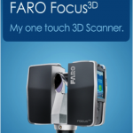
Where do you start with something so vast? Probably the most talked about scanner was the new FARO Laser Scanner Focus 3D. It is a phased base scanner. Not only were they talked about but they received an award for the newest technological advancement. FARO is a very good stable company and has been in the scanning and precision measurement business for many years but the model which list for between $40,000 and $45,000 will definitely find a place in the market. At the same time Leica had its 7000 series and Z&F had their latest advancements in their technology displayed. Presently I don’t think that you can compare the Faro scanner to the Z&F and Leica directly as they will likely fill different niches in the scanning world. The hardware advancements seem to be faster speeds and longer distances. Many had better ways to overlay digital photography on top of the point cloud and auto target recognition. Both of these problems are becoming more manageable with the latest technology. The greatest difficulty of all the scanning products is still the large file sizes you get with an instrument that collects data at a rate of 2 million points a second.
Hardware-Mobile Scanners
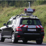
 All the major mobile scanner vehicles were on display in front of the conference center. Topcon, Optech, Riegl, MDL, Trimble (indoor scanner) all had their version of the newest and most advanced Mobile scanners on some very good looking cars. I counted 9 different cars with scanner arrays. Mounted on jeeps and Hummers and even the Mercedes Smart Car they were a very impressive presentation of mobile technology. Through the advancements of better GPS, faster laser scanners, and methodology in the collection, most of the systems can achieve 1/10 of a foot accuracy on the pavement surface and hard surfaces and they scan at speeds approaching 50 miles per hour. This enables them to collect data in areas that are dangerous for surveyors on foot or on surfaces that can only be mapped in constrained time frames like a 10,000 runway at and active major or military airport. This technology has advanced so much it is becoming a very common way to collect data on existing roads and Interstates. Most of the systems usually list in the range of $500,000 to $2,000,000 dollars. It is definitely more cost effective to hire a good service provider on a project by project basis unless you are fully committed to providing the service. These systems have the same common problems that all lidar systems have. Foliage stills blocks the scanners from seeing the ground and GPS satellite blockage in Urban areas is a problem. Both can be solved but require field surveying to pick up additional data. I have several close associates that work with this technology and all say that they work better with survey target locations. I have not ever heard any of them say that the systems could scan through dense foliage and find the true ground. That is why I used the term “hard surfaces” in my description. As more of these vehicles come on line, more and more road miles will be scanned. I can see a time when mobile scanning could be done on a regular basis. One of the most common deliverables is to provide data for pavement analysis.
Underwater Scanners
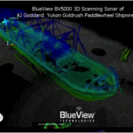
This is the first year I have seen technical seminars on underwater scanners. Companies like BlueView Technologies, IXSEA, 2G Robotics, and DimEye put together a very informative presentation of the technology of underwater scanning. Instead of Laser technology these submersible robots and high-tech mini-subs use sonar technology to scan underwater objects. Some operate at 1000’s of feet deep in the ocean, and others operate in shallow water several hundred feet deep to 5 or 10 feet deep. The data they collect can be used exactly the same way as laser scanned data and some can be modeled in the same software.
 Deep water scanners mostly support the oil and gas industry while the shallow water scanners would be used for harbor engineering or locating and mapping submersed vessels. This is a very fascinating new area that before was left to surface boats to collect. Hydro dam inspection, pier and wharf inspection and many of the areas where the land structures around ports come into constant contact with the water can now be inspected and scanned underwater with reliable results and consistent data.
This technology of 3D digital data is certainly quickly changing the way we engineer the world we live in. (See our next section on new software innovation at SPAR 2011)
H. Tate Jones PLS


Leave a Reply
Want to join the discussion?Feel free to contribute!