
Taking a Chance with Laser Scanning Technology
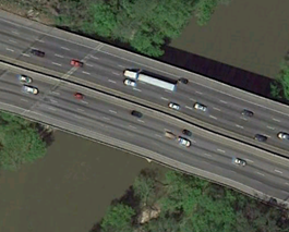 LandAir Surveying began doing business in the 1988 by offering site and topographic surveys to the engineering and construction industry. The company originally started with two survey crews. There were fewer than ten employees and surveying services were offered in Georgia and nearby states. Over the next ten years the business expanded tremendously to include cell tower site surveying services to telecommunications providers. Three-thousand or more cell tower sites were surveyed with conventional survey methods. In 2002 there was a shift of focus to transportation engineering projects and in 2005 we got a project to survey the I-20 Bridge over a large river near Atlanta, Georgia. It was this shift that transformed the technology used and overall business direction of LandAir Surveying. Problems arose with the traditional surveying methods. The size and length of the bridge made it difficult for a survey team to get an accurate survey with the traditional survey equipment. Our owner sought alternative solutions and in the process determined that 3D laser scanning could be used to achieve more reliable results for the bridge survey.
Adjusting to 3D Laser Scanning
LandAir Surveying purchased their first laser scanning equipment in 2005 after viewing demonstrations and since then have expanded into newer and more specific and advanced models. The scanners were used in conjunction with more traditional surveying methods. Work flow methods were refined as experience grew with the new technology. With this increased experience 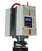 came calls for exterior, interior, and structural surveys of various buildings and environments. 3D laser scanning made it possible to easily scan a building and produce drawings and 3D data sets based on the scan. Time required to produce an accurate survey was reduced with the help of this technology. Enhanced scanning allows surveying of building areas that are not easily accessible without the technology. Larger jobs such as wide spread manufacturing facilities have more accurate site surveys with complete 3D imaging and laser scanning is becoming more of a standard in these environments. These types of surveys would not be possible with traditional surveying methods. Data processing had to be refined to better handle bigger data sets created by laser scanning. New scanning innovations have created safer work environments for surveying crews and new business opportunities.
3D laser scanning is quite different from other surveying methods. With this technology, field notes do not exist. Instead, surveyors strictly deal with data points and image files. A typical 3D laser survey project work flow is to set up the equipment and seek a line of sight for each point. Scanning devices use technology that floods a area with precise data points at rates of up to 300,000 points per second. After a scan is complete, the information can be viewed, verified, and referenced whenever necessary. Files are large in size and have to have the right computer power and resources for proper management. Machines with vast amounts of RAM and enhanced graphic cards make critical post-processing more reliable. These computers must be capable of supporting vital processes such as proper data workflow, storage, retrieval, and backups. While the service is advantageous, we found that more effort is required to find clients who can benefit from the technology. Initially clients could see the benefits, but not all could afford the service. However as the technology grew and became more efficient and the benefits became more reliably more companies are using this technology as a way of surveying existing conditions. Having been in the 3d Laser Scanning business for 7 years our firm has become an industry leader in this emerging technology.
Leave a Reply
Want to join the discussion?Feel free to contribute!