What can you do with a 3d Laser Scanner
What can you do with a 3d Laser Scanner that you cannot do with other types of surveying and mapping equipment?

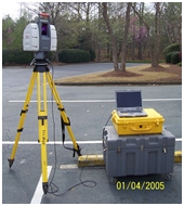
Scanner on 5” standard Tri Pod
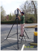
First let’s look back at where the 3D Laser Scanner came from. Some people call it a Laser Scanner; Aerial mappers call it tripod scanning. I think it is more widely known as terrestrial scanning. So laser scanning as I am talking about is all done on a tripod that is anywhere from 5’ tall to 15’ tall. Most are moved around either on wheels attached to the tripod or by hand or now we even have truck mounts to improve speed. As I said in my first article the uses’ for this technology are as varied as the imagination. So what do they do that other survey and photographic equipment does not do. Let’s look at what they do very well. They collect very precise points in space and a very high rate of speed and the photography gives the laser the ability to color these points. This seems like a simple thing and one could wonder why it is such a big break through. Because these points are precise one is able to go scan and object and then reproduce that same object in a computer. Not only reproduce the dots but reproduce almost every feature that comprises that object.

3DLaser Scanner being mounted on a 15’ tripod
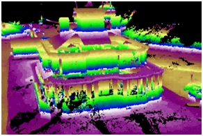
In 2005 the movie “Troy” was being produced and the need for a very good replica of the Parthenon needed to be built on set in Hollywood California. You could imagine the amount of work it would have taken to get hundreds of people with measuring devices to go and measure the real Parthenon and then draw up the plans. This was a perfect job to do with the new 3D Laser Scanning technology. The movie company hired a scanning company to go over to Italy and make a very thorough series of scans. From these scans which were accurate with in a ¼ of an inch detailed plans were drawn up and the replica with constructed from the plans produced by the scanner. The point here is that this is the perfect instrument to completely and thoroughly map existing conditions. That is one of the strongest features this computer/machine produces. The first scanners came from LIDAR technology.
LIDAR (Light Detection And Ranging) is an optical remote sensing technology that measures properties of scattered light to find range and/or other information of a distant target. The prevalent method to determine distance to an object or surface is to use laser pulses. Like the similar radar technology, which uses radio waves, the range to an object is determined by measuring the time delay between transmission of a pulse and detection of the reflected signal. (source wikipedia).
The first uses of this technology were in aircraft mapping the earth surface. The rapid fire laser technology would send out a light beam at a high speed using a very powerful laser and it would hit the earth and create a point. With millions and millions of these points created from the laser pulses a very accurate map of the earth surfaced was generated. A gentleman named Ben Kacyra understood the technology and with the help of his partners and funding invented the first terrestrial 3D Laser scanner. His reasoning was that he worked in the piping industry and he was looking for a better way to map complex piping runs in refineries and heavy industrial complexes. The technology worked well and from there on was expanded in to the more sophisticated scanners we have today.
So the best feature of the scanner is that it can precisely map existing conditions and this ability has been translated into many fields. A whole new field of 3D engineering has evolved around this technology. Our first use of the technology was in existing road surveys for the Department of Transportation. LandAir Surveying has a long history of working with the Georgia department of Transportation. We were surveying a very long bridge over Atlanta’s biggest river and we were having a very difficult time capturing all the existing bridge structure using single point total station survey technology and meeting the specifications. As an experiment we tried the same work with a 3d Laser Scanner and we captured all the information we needed with little difficulty. That was our first project and since 2005 we now have completed hundreds of projects.
Some of our more memorable projects included:
Providing our client with a floor as built of a building that was approximately 500,000 square feet. The client was a contractor and they needed it for their client to determine that the floor met the specification for being level. In two days we scanned and captured about 10,000,000 points. Then we presented the data to the client firms in colored contours that we 1/8th inch contours and every time it changed by another 1/8 inch the color also changed. Ultimately we provided them a 10 foot grid and the floor did meet the specification.
We have surveyed structural walls that were either settling or sinking and we survey the amount of settlement over a period of time and showed graphically and with excel spread sheet how much movement we detected.
We have surveyed mines both above ground and below and underground and were able to give the client a map of the existing conditions. In doing this we also were able to keep our crews safer and they did not have to go into the working faces of the mines which can be very dangerous. Because of the range the laser collects data we were not with in what the miners call the “working face” area which is much more susceptible to falling rock and surrounded by large heavy moving equipment.
As we go forward in this publication we will talk more and more about the different types of projects we have worked on and how the scanner was used to collect information that otherwise could not be collected.

