Posts

Autodesk University 2012: watching an industry grow up!

Attending and exhibiting at shows like Hexagon, Spar, and Autodesk University is always fascinating because you get to interact with clients all over the country and see what’s new in the industry.

This was our first time exhibiting at Autodesk University, but having been to three conferences in Las Vegas in one year, I was quite familiar with the surroundings. At this year’s show – which was attended by over 8,000 people from 102 countries – what I saw was an industry that has grown up and is beginning to make a real impact on design and construction.

I remember in 1986 when a new drafting program named AutoCad came out and everybody was debating if it would become the standard…it did. And it brought with it – along with the digital age and computers – the plotters and all that went with the introduction of this new paradigm.

Most of us waited to see how it would be received in the industry, but then – as now – it proved to be a very valuable tool.

And just a few years ago, we were all still discussing the advances in AutoCAD and Civil 3D.  Though we knew these programs would remain relevant, it was evident from all of the different software that interacted inside of Revit and enhanced the user experience that the world of 3D design was here to stay. (As a friend of mine said not long ago, “If you are not designing and interacting in 3D and models, you are quickly going to be obsolete.”)

Autodesk University 2012 showed us how design is being done today and where it is going in the future. One of the more interesting observations was that besides the architects, engineers and designers, there were contracting companies, retail companies and owners all talking about the new Autodesk programs that were being used in the workplace.

There was lots of talk in these groups about building “Revit families” specific to their business types, as well as discussions around how to mix the contractors (who have the knowledge about how a building is built in the actual world) with the BIM modelers so that the models are also constructible.

This will be a big challenge. Contractors and superintendents who know how to pour a slab and build 20-story buildings have knowledge and insight that is absolutely critical to building a proper BIM model.

As any techno geek, I am always very interested in the new products on the exhibition floor and the showcase included hundreds of third-party vendors developing exciting products that work alongside Autodesk.

There were lots of new software and hardware lines in the 3D laser scanning industry, as well as new software offerings for BIM models, Revit technologies and GIS products. But for me, the most intriguing products were related to 3D printing applications.

These fabrication and modeling solutions enable products to be created directly from their computer models.

Almost anything you could imagine – from cars to motors to guitars – was printed and on display. Though 3D printing has been a popular topic in recent years, it was there, it was real, and it will definitely change how items are built in America and around the world.

At the conference in Vegas, there were actual printers producing objects out of wood, metal and polymers. The only difference was whether the printer was loaded with plywood or metal.

BIM is an acronym for Build Information Models, meaning to build computer models that have built-in intelligence. What I observed was BIM in the context above – building models and objects with just the information in a computer.

My, how we have grown.

###

Tate Jones has over 40 years of experience in land and aerial surveying and was one of the country’s earliest adopters of 3D laser scanning technology. A nationally recognized expert in the field of 3D data capture, he has worked with hundreds of clients in the engineering, architectural and construction industries. Contact him at tjones@lasurveying.com or visit www.landairsurveying.com.

Where we are now…and where we’re going.

As 2012 winds down and we get ready to head to Las Vegas for the Autodesk University conference, I look back at the strides that have been made in the 3D world and all of the associated hardware and software in our industry.

Not only is there new technology being used and accepted, but the demand for more BIM products, users, and technologists has grown faster than ever. I have also watched with great interest the wave of corporate acceptance that was not there even three years ago.

There is still much ground to be broken, but wow – what a year!

New Software

Take software, for example. As I travel around America and talk to user groups and clients, the one thing I am always asked is when will it be easier to model point clouds into usable entities?

There is much research going on to solve this challenge. Though I have no commercial interest in this firm, I believe one of the ones to watch in this space is ClearEdge 3D. Their EdgeWise Plant software is pushing the barriers away for modeling point clouds.

Personally, I believe that within the next three years, this major barrier we face now will be a minor issue and point cloud use will continue to grow and expand.

The other great leap in technology is that most of the major software packages have updated their products to accept point clouds as a layer. This means that most of our clients in the architectural and MEP worlds can now import our point clouds into their design software and greatly enhance their designs.

Just three or four years ago, using point cloud data required modeling and this limited the market to mechanical and structural engineers and various contractors with specialty software.

Today, because all Revit users can import point cloud data, the need to model everything in a scan project has been greatly decreased. This is a big deal! Now, instead of having to pay for an expensive model, end users get all of the benefits of point cloud precision without the associated costs of modeling.

Not to be overlooked, there are still issues that will need to be ironed out in inserting point clouds into design software, but they will be overcome with time.

For example, if you are working in Inventor to model plant process data, it is best if the project is modeled from start to finish in Inventor. Similarly, if it is to be modeled in Revit, it is best that it be modeled from start to finish in Revit. There are no readily available universal translators to move from a model that was created in Cyclone to a model in Revit while keeping the full integrity of the original model.

Though the data itself is globally transferrable, the structure of the models, entities, families and libraries requires more work to be done in this area.

New Hardware

Last year, I predicted that the hardware in our industry was set and that most of the changes would come in the form of software. On this point, I was wrong.

Several changes have occurred that continue to advance the hardware. For example, The Faro Focus 3D has broken the price barrier. Prior to its release, most scanners started around $80,000 and went up to $200,000. The Focus was released at about $50,000 and has caused price adjustments throughout the industry.

I believe this trend will continue and prices will continue to go down. This is both a good and bad thing for the industry. As prices go down, more people with marginal training and experience will begin to use scanners and bad point clouds will become more of a problem.

There is a saying in our industry that “one bad point cloud kills a lot of clients.” Indeed, this is true. I have talked to clients who tried laser scanning nine years ago, had a bad experience, and will not use it again to this day. The problem is not that scanners are getting more affordable, but that there are still no national standards in the industry.

The upside is that with a lower cost competitor, vendors must consider what value their laser scanners bring that others do not.

Cool New Technology

Two things I am really interested in and know will change the playing field moving forward are   aerial drones and augmented reality.

These two technologies are growing fast and have many great uses. A traditional helicopter used to map utilities and large areas generally costs about $25,000 per day. A one-meter drone quadripod, on the other hand, costs about $2,000 per day.

Though there are unique tasks that the smaller one-meter drones can do that the helicopter is currently doing, there are other tasks that the smaller drones can perform that traditional helicopters cannot do. For example, smaller drones can more effectively and safely map underground pipes, mines and tunnels.

Currently, to send two scanner technicians into a tunnel requires about six surface and sub-surface support staff. An unmanned drone with avoidance technology would be a great solution.

Augmented reality and the ability to project 3D images easily and to large groups is available and is changing the whole world of education. A small but growing company, ViziTech USA, is doing very creative and trendsetting work in this area.

This is where the science of 3D technology is repackaged so that the average person can use and understand it. This is a powerful tool and will lead to great changes in many industries and educational processes. For more on augmented reality, read our recent blog post here.

The design and construction of future projects will still require the same basic processes that are required today. But the use of precision data before, during and after construction – and the visual way the data can be viewed – will greatly reduce errors and downtime events.

###

Tate Jones has over 40 years of experience in land and aerial surveying and was one of the country’s earliest adopters of 3D laser scanning technology. A nationally recognized expert in the field of 3D data capture, he has worked with hundreds of clients in the engineering, architectural and construction industries. Contact him at tjones@lasurveying.com or visit www.landairsurveying.com.


3D laser scanning revolutionizes construction site accident investigation and evidence collection

In early October 2012, several construction workers were killed or injured when the Miami Dade College parking garage collapsed like a pancake, trapping a then-unknown number of workers inside (See http://tinyurl.com/9956xae). Some survived, but some did not.

Post-accident site investigation

Since this tragic loss of life, injury, and property damage, lawyers have no doubt already begun what will be expensive and lengthy litigation. The owner, architect, engineer, contractor, subcontractors, construction workers and their families will all play a part.

The evidence may be sifted and sorted for years before any judges or juries hear about what happened on that fateful day.

Ideally, each party would have ample opportunity to investigate the site, take measurements, and form opinions as to what happened. However, this was not an option in Miami.

Workers needed to be freed. The structure’s potential for further collapse endangered all those around it. The owner had a dangerous pile of rubble where a new parking garage was supposed to stand. Certainly, nobody wanted to preserve site conditions for any length of time.

So, how can evidence of existing site conditions be preserved forever? 3D laser scanners were dispatched to the site immediately.

From onsite scan to a 3D model on your computer

Similar to traditional surveying, 3D laser scanners are set-up on tripods and use light to precisely measure their surroundings. But whereas traditional land surveying instruments take only one measurement at a time and need a reflector to return the light, 3D laser scanners take millions of measurements of everything that they can “see”  within 300 feet.

This data is collected in a matter of minutes and the instrument can be set up as many times as necessary to see the entire site. Technicians then convert this raw information into a 3D model.

Lawyers and their experts can use this model to return to the day of the accident at any time.  They can pan and zoom around the model to find any desired vantage point. Any angle or distance can be measured and re-measured.

Collecting quality evidence

After any given construction accident, investigators take photographs, make measurements and sketches, and interview witnesses.  However, even the most seasoned investigator can miss critical details due to time constraints, site access, or simple knowledge of the facts.

Once the site is cleaned up or altered in any way, the evidence is spoiled. However, 3D laser scanning allows investigators to return to the site at any time to retrieve missed or forgotten details.

Additionally, the evidentiary quality of 3D laser scanning data far outweighs traditionally collected evidence. Photographs provide only a single 2D perspective and each detail must be specifically targeted. Manual measurements are subject to observational and recording error.  Witnesses certainly cannot permanently remember every visible detail, especially in the wake of a tragedy. 3D laser scanning overcomes all of these limitations.

Full access to the site is often limited, for example, from the danger of additional collapse and loose rubble around the parking garage in Miami. This problem is also overcome with 3D laser scanning, as it uses light to measure from a distance. Anything that can be seen can be scanned and recorded for later review.

Using the model at trial

3D laser scans are not new to the courtroom and readily pass muster under evidentiary challenges. Foundation for entering a 3D laser scan on the record can be laid by a professional land surveyor, but courts nationally have allowed scans based on the testimony of laymen who were simply certified to use the equipment.

At trial, 3D laser scans provide unparalleled demonstrative exhibits. Judges and juries will no longer need to travel to visit a site.

As noted by Lt. Warren Hamlin of the Knox County Tennessee Police Department, “It’s almost like taking the jury right to the crime scene. We can show pictures all day long, but when you’ve got a panoramic view that shows exactly how it looked and where everything was, that’s a much better depiction than a photograph. … So, if a guy says, ‘I was standing in that corner,’ you could create a viewpoint exactly where his head would be and look around the model and tell whether, yes, he could see that, or, no, he’s lying.”

###

David Headrick has over 14 years of experience in the surveying, engineering and legal industries, both as a project manager for LandAir Surveying and as a lawyer in private practice. He has represented numerous land surveyors, designers, architects, contractors and other industry professionals throughout his career. Today, David serves as an executive and project manager for LandAir, focused on developing and managing the company’s 3D laser scanning department. Contact him at dheadrick@lasurveying.com.

The Next 3D Scanning Frontier: Transportation BIM and Augmented Reality

As I stand back and look at where 3D laser scanning has led us as a company, I am both pleased and confident that the world of 3D virtual design and engineering is healthy and growing fast.

I recently met some truly amazing people from all over America and Europe who are doing some very forward thinking things with 3D virtual reality in both transportation BIM systems and augmented reality. Here’s a snapshot of what I saw:

Transportation BIM Systems

I was in Washington, DC, a few weeks ago speaking at a large corporate meeting and had the opportunity to see a fascinating presentation on the San Francisco Bay Bridge construction.

The construction cost will come in around $7 billion (yes, billion). The metrics are staggering, but there are four major construction firms working on the project.

Cal Trans has scanner crews scanning the progress on a weekly basis. Because of this, there was room in the budget and the available technology to do real time clash detection of the existing and proposed construction.

Because the bridge was designed in 3D (really in 5D), engineers were able to save big bucks on relatively simple components. For example, the 3D scan allowed them to get real time views from the proposed security cameras underneath the bridge. As a result, the actual number of cameras was cut in half, saving several million dollars.

Crews also used 4D (time) clash detection to view when a new component of the bridge was being constructed while an existing component was still in place. The 4D BIM model, when clashed against the existing model at that moment in the construction sequence, showed that there were interferences in temporary construction items.

Though the clashes would not have interfered with the final design, they did interfere with the interim design and would have slowed construction. This knowledge allowed the designers and contractors to make modifications to the sequences before there was an actual problem.

Just a few years ago, this capability would have been unheard of!

One of the more astonishing things I saw was a 5D construction sequence video that showed the bridge’s proposed construction slide bar and dollars spent on overtime as the bridge was coming out of the ground or water. This enabled you to compare construction costs to the bridge’s progress. At this same time, the 3D graphic was color-coded to show the four separate contractors and their workflows.

This all sounds complicated – and it was – but through the 3D engineering process, you could view the time estimates, add the construction dollars, and come to a very natural conclusion as to what was actually taking place. You could confirm that one contractor had finished his new section before another section was tied into it.

A 3D video showing a major component – like how the cabling system would be threaded through the bridge to provide the final structural support – was also very intriguing to watch.

Augmented Reality

This may be one of the biggest and best changes that I foresee coming to the construction industry.

Augmented Reality (AR) is a live view of a real-world environment whose elements are augmented by computer generated sound, video, graphics or GPS data. If you consider that most new construction will first be built by engineers and designers in 3D in computers, then you may see where we are going with this.

With the base designed in 3D, you can then place a “target” in a construction zone. A target for augmented reality can really be anything as long as a tablet or cell phone can recognized it as graphic signal to launch 3D BIM programs.

These targets are used to orient the tablet to the exact same design point as where the construction is occurring on the ground. When targets are scanned with a tablet, the original design for that exact spot of construction is displayed. As the tablet is moved around this area, you can view the construction in 3D at a specific location.

Here’s an excellent example: Assume that you have a three-sided, multi-story concrete opening for a proposed staircase. By scanning the target placed in that area, construction workers can see on their iPad or Android tablet exactly what the finished product will look like. Not just a flat drawing on 600 sheets of blue lines, but the 3D model of how it will actually fit into the opening.

And remember: the world is international and these projects are under construction all over the world. By doing this, we just transcended the language barrier. We just solved the problem of expert tradesmen who are great at their craft but may not read details on blueprints that well. We just got a crew of 2-5 construction workers from a point of unknown to a point where everyone has a perfect mental picture of what is going to be constructed. That’s a huge step!

One of the oldest sayings for any worthwhile project is, “Begin with the end in mind.” What a great way of accomplishing this.

As a testimony to how well this is working, many construction companies have been rolling out flat screen computers onsite to show superintendents actual BIM models by sequence. All throughout the day, they are used over and over by the workers who are building bridges, buildings, and infrastructure around the world.

These rolling 3D models are helping to get projects constructed right the first time. They are preventing construction problems and saving big money. Very soon, I believe that all of this will be done with either special glasses or projection screens.

Currently, the only obstacle slowing the process is having a way to orient a 3D BIM model real time inside of a building. Outside, it can be done with GPS. But inside, it is more challenging.

However, augmented reality will very quickly make paper plans obsolete. I have seen it in too many places and have seen the benefits. It is coming and will soon be a standard. All of the major construction companies are embracing this technology.

Another real use of augmented reality will be in the operations of the finished building. The technology already exists to allow a maintenance worker to go up to a motor or valve (or any piece of equipment that has a target) and scan it with his tablet or phone.

This opens up a computer database so that he can see the last maintenance schedule and the internal parts of the machine. If he services the machine, his data is automatically sent to the company database and is available for anyone to review. Or, if a repair is needed, he can launch a video of how to take apart the machine and replace any part he needs.

This brings the power of the “owner’s manual” and the entire knowledge stored in the computers running the facility in real time 3D to the exact point it is needed. Imagine the implications if you own a complex manufacturing facility.

In just the past seven years, I have seen strides that were only imagined 10 years ago. But today, it’s all happening – and there are very creative people all over the country working on even more and more innovations. It’s an exciting industry to be working in!

###

Tate Jones has over 40 years of experience in land and aerial surveying and was one of the country’s earliest adopters of 3D laser scanning technology. A nationally recognized expert in the field of 3D data capture, he has worked with hundreds of clients in the engineering, architectural and construction industries. Contact him at tjones@lasurveying.com or visit www.landairsurveying.com.

An armed robbery, a high speed police chase and…laser scanning?

Sometimes I don’t have to look past the front page of the local newspaper to see a good example of laser scanning in action.

Tragically, there was a police-involved shooting in Cobb County, Georgia, this past weekend, as reported by the Atlanta Journal-Constitution. The suspect allegedly robbed a gas station and then led the police on a high speed chase. The chase ended on I-75 when the suspect pointed a weapon at the police officers and was shot dead.

This was a very unfortunate incident, but the impact on the community was far lessened due to the outstanding work of the Georgia Bureau of Investigation.

The shooting and subsequent chase left many cars wrecked and damaged and, ultimately, the interstate was forced to close temporarily. As you can imagine, this was not a calm situation.

The GBI dispatched their laser scanning team to the site to set-up and scan the area to document the evidence both known and unknown at the time. They also generated 3D photography to further document the area in its entirety.

Using this method, they not only saved time, but were also able to quickly collect the data that would be necessary if the case were to go to trial.

So why use laser scanning to document a scene like this?

First, consider the sheer size of the scene. In this case, the area of study was larger than a football field. Without scanning, investigators would have had to take multiple photographs and make measurements with total stations that shoot one point at a time or worse, measure with 100 foot-long measuring tapes.

This takes much more time, requires more people, and creates much more chance for errors. The errors could be wrong measurements or even missed objects.

When you combine the laser point cloud data with the photographic data, the measurements and the scene become much more intuitive and obvious. You can place the evidence markers by the evidence within the scene and the scanner automatically picks them up.

Instead of making and recording many different angles and distances, you simple put in the points per square foot you want to capture into the scanner and in about 15 minutes, you have a completed scan with photography.

You can look at the scan and very clearly see the markers and measure from any object in the scan to any other object in the scan. So, if you need to know how long a skid mark is, for example, you would just click two points – one at the beginning and one at the end – and the measurement would be instantly generated.

With laser scanning, time at the scene is used to locate and mark the evidence and important points in the scene. All critical measurements can be made offsite after the scene is moved and the traffic is moving again.

Here’s the most important part: If you need information about the scene, but did not know it at the time of the scan, all is not lost! If it exists in the scan, you can make all the measurements you need to document the new (previously unknown) evidence.

More and more, laser scanners are being used to document crime scenes across the country. District attorneys like the scanned data because they can easily view it.

Scanned data is totally objective in that it collects the whole scene. It is easy to put a point down on the ground every square inch so that the coverage of the site is complete. Additionally, the fact that no one has to decide what measurements are made in the field before they release traffic is very important.

Judges like the data because the jury does not have to visit the site to understand the scene. Instead, they can simply view it in 3D on a computer screen without leaving the courtroom.

Laser scanning also saves time and money. Traffic still has to be stopped for an investigation, but if not for laser scanners, it would be stopped longer and there would be less information collected.

###

Tate Jones has over 40 years of experience in land and aerial surveying and was one of the country’s earliest adopters of 3D laser scanning technology. A nationally recognized expert in the field of 3D data capture, he has worked with hundreds of clients in the engineering, architectural and construction industries. Contact him at tjones@lasurveying.com or visit www.landairsurveying.com.

The Future of Laser Scanning: 5 predictions for design and construction

In a few weeks, I am speaking at a conference about the future of laser scanning in the design and construction world.

The audience will be members of a top international construction firm that is very progressive in its use of BIM and 3D laser scanning, so it got me thinking about some of the research I have done and observations I’ve made at various 3D laser conferences over the last eight years.

Based on the incredible innovations in our field in the last decade, I have five predictions as to how high definition scanning will change design and construction in the near future:

#1: Rapid and creative increase in the use of the technology. 

When GPS hit the market in 1992, we were early adopters of the technology and found great savings for our workflows as a result. For one, what used to take us two to three weeks of field surveying could now be done in just hours.

While there is still pushback in some sectors of the design industry related to laser scanning, contractors are largely on board. No other single group gets a better return on investment for the dollars spent on laser scanning.

Every major building contractor I know is using the technology in some way. The reason is simple. If something is designed from old plans and doesn’t fit, it is the contractors who will have to pay to make it fit. They live in the world of construction schedules and why is not nearly as important and when and how much!

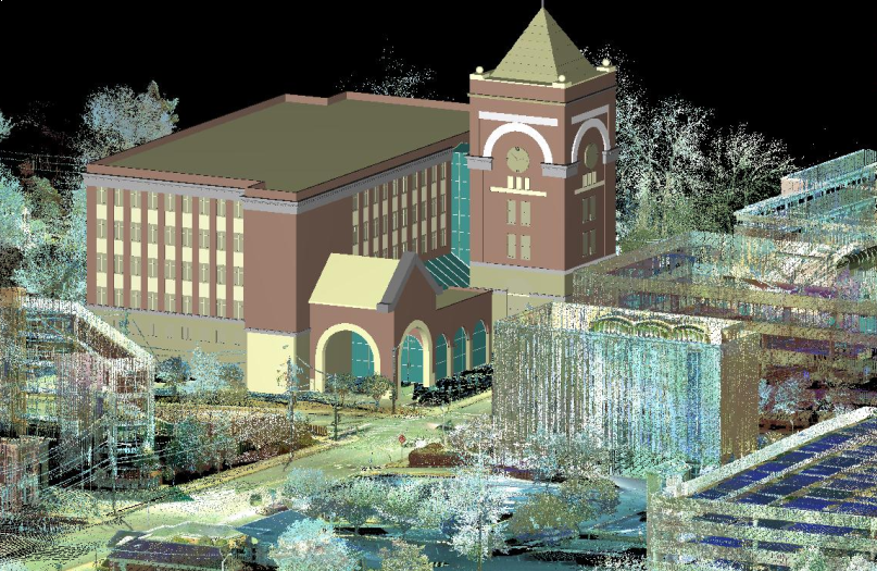
The use of this technology will only increase in the future. Currently, 3D laser scanning technology is being used to show floor flatness with 3D contours well before the new floor is built. As a result, if there are any critical departures from the plans, they can be fixed for a fraction of the cost of what it would be once the walls are already in place.

BIM models are being compared to the laser scan in real-time so minor changes can be made before they turn into a major – and expensive – problem.

As we go forward, I see a time that scanners will be attached to each floor of a building as it goes up and will robotically scan at appropriate times, allowing the laser point cloud to be compared and clashed every night or even hourly to the BIM model to detect changes between the design and construction.

This technology has already reduced the cost of construction and will go upstream to reduce the cost of project insurance because it lowers risk.

#2: Video vs. Laser Scanning?

Ironically, one of the innovations of 3D laser scanning will be using the laser less and the iPhone more.

For many years, “close” range photography has been able to create accurate as built information. Used by experts who understand the survey control necessary and the techniques required, the results could be better than laser data.

Now there are firms writing software that can produce point clouds using video or multiple pictures of the same object (which is what video really is). With no control, it does not have the same accuracy as lasers, but the cost is significantly less.

There is a debate in the 3D world whether this will replace laser scanning or compliment it. I suspect the latter.

One study I read said that creating point clouds from photography currently was about 98% as accurate as a laser scan on smaller areas. That said, if you measured a room that was 100-feet long with a point cloud based on photography, it could theoretically give you a resulting measurement of only 98-feet long.

Consider this: How many times is 2% good enough? The truth is, many times it is. One of the oldest problems in scanning is how to get above the ceiling tiles to document the utilities above.

Getting a scanner up there is slow and expensive. Removing the tiles is slow, dirty and expensive. But if you could remove a few tiles and snap a few pictures, you could get an accurate inventory of what was there and where it was going that would be extremely helpful.

Much research is being done in this field, but I think in a very few years – depending on the specifications – we will be using cameras as often as lasers.

#3: Intelligent point clouds

This is where much of the research in software is going.

Right now, there are some programs that can model pipe correctly between 70% and 90% of the time. They can also recognize walls and show some, but not all, of the flat surfaces.

While this is a huge step forward, if only 80% are right then you have to check 100% to see which are wrong. You would not want to order a couple of hundred feet of the wrong size pipe and have in onsite only to find that it was the wrong diameter.

In the design world, it has always been our opinion that no data is much better than bad data.  Ironically, the current software does have excellent object libraries, so you can isolate the point cloud of a structural I-beam and ask the software to find the right part and it does a great job. However, though it is a more reliable process, it is a manual process.

I believe this problem will be completely solved in less than two years and the use of point clouds will increase exponentially.

#4: Why create a model at all?

At the risk of creating total confusion, there is a growing group of expert users that ask this very question, why model at all? Their thinking is that when you model, you change the shape of the object scanned and the cleaned point cloud is a better representation of an object.

That being said, with the ability to bring the point cloud into design programs, more professions – especially the high precision users – are designing inside the point cloud and not from a model.

I saw a fascinating presentation by a satellite designer. When another payload was added to the satellite, he would not work off the plans, but instead scan the existing satellite in the next room and use that point cloud for the additional design. Of course, we don’t all have the luxury of having a working copy of the design next door.

The important point here is that for critical design, the point cloud is closer to reality than the model. The other realization is that nothing is ever built exactly as it was designed.

#5: Advanced data capture platforms

This will be one of the biggest changes and most fun to watch.

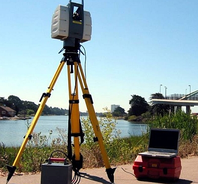
Currently, we use helicopters, fixed-wing aircraft, automobiles, trucks, off road vehicles, boats, and tripod-based systems to collect data. Though these work well for most uses, many of the projects that need scanning are in dangerous conditions. (Tunnels, large underground pipes, underground mines, failed construction areas, high voltage transformer stations and nuclear power plants.)

All of these areas have one thing in common: they are unsafe.

Enter drones and walking robots. When the nuclear power plant in Fukushima, Japan, failed and melted down, the level of radiation was so high that the workers could spend very little time inside the radiation zone.

The team brought in a small drone that delivered high quality close range aerial photography and was equipped with avoidance technology so it would not fly into a fixed object. The digital information was extremely valuable in assessing the damage and did so safely with little human risk.

I have already seen experimental drones equipped with small scanners that are programmed to scan flat surfaces and recognize open areas like doors. They will go through to continue the scanning in areas that, because of gas or other dangers, would be very difficult for humans to work in. In studying the decaying infrastructure of America for rehabilitation, can you imagine being able to put a drone down the sewer systems of New York City or Atlanta and get high resolution scan data without having to put people in such an environment?

Track mounted robots are being used in the same way. These will definitely be used more and more in the future and will change the way we work.

The future of scanning is immense and the different ways we scan – the data capture vehicles and the software – will continue to evolve and become more customized to the specific industry problems presented. Point cloud data, whether collected with lasers or iPhones, is still the best data that exists for capturing and studying existing conditions.

The future will be exciting to watch and the prize goes to the person or company that can best see beneath dense foliage, behind walls, or under the ground.

###

Tate Jones has over 40 years of experience in land and aerial surveying and was one of the country’s earliest adopters of 3D laser scanning technology. A nationally recognized expert in the field of 3D data capture, he has worked with hundreds of clients in the engineering, architectural and construction industries. Contact him at tjones@lasurveying.com or visit www.landairsurveying.com.

3D Forensic Scans: Three civil applications

In my travels along the 3D laser scanning superhighway, I’ve spent a lot of time talking to criminal forensic experts. This group was one of the earliest adopters of laser scanning technology and I’ve had the pleasure of meeting agents with the FBI, the Secret Service, and even generals and admirals who are familiar with its capabilities.

In my experience, the most advanced groups in the specific application of the technology to prevent and investigate crimes have been the Secret Service and Scotland Yard. Both have programs written specifically to analyze the data and use it proactively to protect kings, queens and presidents.

High definition scanning allows you to check every site line – not just one or two.

Our firm has worked on several “criminal” projects over the years – some supporting the prosecutors and their evidence and others supporting the defense teams and their clients. But we also work with the litigation and documentation of forensic evidence for civil or construction projects.

Many jobs require our expertise to go out and document the existing conditions of a site. We have literally traveled from Montana to Texas to Georgia working with clients on various cases.

Perhaps the most famous civil forensics projects were the scans used for analysis of the World Trade Center attacks and the Minneapolis bridge collapse. On both of these projects, the scan data after the destruction of the structures was used to determine exactly what caused the failure.

Obviously, in the World Trade Center, the initial impact of the plane created the fire ball and damage, but it was the fuel in the plane that heated up the beams in the structures and ultimately caused them to fail, each floor collapsing on the one below as the entire structure came down. The melted beams were documented with laser data.

Structural Integrity

One of our first projects was scanning a three story parking deck. During the initial walk around, we could tell that the deck – even though made of concrete – was warped and some of the columns were out of plumb. Other areas were cracked and stressed.

We produced plans and models with the data and structural engineers were able to determine that the structure was unsafe. Because of the density of the data sets, engineers were able to look at all surfaces rather than a few strategic spot shots before making their final determination.

By being able to look at the line of the vertical columns through the building, engineers could tell that the cost to fix the failing structure would be much larger than building new.

Large Vessel Analysis

We also had another project where we were asked to scan a large containment vessel that held various types of liquid depending on the product being produced or stored.

In this type of investigation, we were able to document that a certain vessel was out of plumb, warped or bent. This information was then used to determine if the vessel was safe and, if not, how and when to replace it before a failure occurred.

Settlement Monitoring

Being able to monitor when and how much something is settling is very important to a property owner. We recently worked on a very large project in the western United States that involved a large platform used for loading and unloading products.

In this case, one long section had settled much more that the specifications allowed and had begun leaning at a dangerous angle. The engineer showed me previous surveys and I asked him why they needed us if they already had survey data on the structure.

He explained how the parties involved were having difficulty understanding the traditional survey data and its implications.

Once we scanned the platform in 3D and modeled it, it was quite obvious to everyone how badly the shape of the original structure had changed, as well as the principal cause of the failure. This helped move the group discussion from, “There isn’t a problem,” to “How do we get this fixed?”

We have completed many other civil forensic projects for engineers ranging from dam failures to vertical wall failures and even construction slabs that were not level or flat. The common element in all of these projects was that the use of laser scanning technology was the perfect tool to document the conditions and the data was easy to interpret and model into a visual form that everyone could understand.

Forensic scanning of crime scenes will continue to grow, as will the 3D laser scanning of complicated civil projects. 3D laser survey data is becoming mainstream in analyzing the cause of catastrophic civil construction failures. If you know how something fell to the ground, you can usually tell what failed first.

###

Tate Jones has over 40 years of experience in land and aerial surveying and was one of the country’s earliest adopters of 3D laser scanning technology. A nationally recognized expert in the field of 3D data capture, he has worked with hundreds of clients in the engineering, architectural and construction industries. Contact him at tjones@lasurveying.com or visit www.landairsurveying.com.

Young innovators push 3D design and high speed data capture to new heights

When we were asked to bring our booth and support the 2nd Annual Revit Technology Conference in Stone Mountain, Georgia, last week, I didn’t know what to expect. But I’m glad we went because we saw the future – and it’s very bright.

For BIM managers and designers, this conference was a look through the hourglass of the future at the world of design and one thing is for certain: gone are the days when firms could avoid BIM, 3D Cad modeling and laser scanning and still hope to be competitive. What I saw were bright young innovators already pushing the technology of 3D design and high speed data capture to the limits.

It was very refreshing to attend a conference where presenters and attendees agreed that 3D laser scanning was the best tool to use in many design situations and were openly discussing how they currently used the technology in innovative ways.

The largest 3D scanning show I attend every year is SPAR. I had the same feeling at the Revit Technology Conference last week that I had at the third SPAR show back in 2005 when laser scanning was still a new and relatively untested technology. The quality of what was being presented at the Revit conference – and how and who was presenting – was way up on the charts.

Around the showroom floor, there were the larger suppliers of the Revit technology, who were very knowledgeable about new improvements to the products, alongside many boutique firms that were selling all types of software to make the design process in Revit easier and more organized.

There were also other groups selling “cloud” technology that provided a new, more efficient vision of the cloud. While most of us already have data on our iPhones, it will be a short time before we will all have our data in the cloud and projects will be able to be worked on by anyone, anywhere with just a password and a computer.

On large mega-projects like new airports and major industrial facilities, multiple design teams in multiple cities will be able to work on the same cloud-based data at the same time. It will change the way we do things forever. Yes, there will still be security issues and priority issues, but ultimately that’s where we are headed.

Why have one computer process for one million seconds to solve a data set if you can have a million computers process for one second? It’s not quite that simple, but that’s the goal.

The speakers were great, too.

My favorite was Dick Morley. His opening presentation was in the form of a fireside chat with Brad Holtz serving as the interpreter. (I say interpreter because when the audience looked confused and a topic seemed to go over our heads, Brad would bring Dick back down to earth.)

Dick Morley invented the programmable logic controller, which pretty much controls all the electronic machinery in the world. To put it in prospective, that one device produces more revenue than all of Hollywood’s productions combined.

He also invented antilock braking technology, which revolutionized cars and greatly reduced accidents on the highway. (As a side note, he said that while the number of accidents decreased for many years, they slowly started going back up as drivers in America learned to drive closer using the antilock brakes. As the margin of error decreased, accidents increased.)

Dick also invented the cash register overlay that has pictures of food on it rather than numbers. This greatly reduced errors and increased production in the fast food industry.

Dick, who was trained in physics at MIT, had a clear message: “Look at where things are going and what needs to be solved and find the technology to solve it. Holding on to the way it has always been is just a reason to justify where you are – not a plan to move forward.”

I think this is true across the industry. The true leaders and innovators are not the ones who are really good at getting a piece of paper from the left side of their desks to the right, he said. The innovators ask, why paper?

Other interesting speakers shared new and innovative ways the power of 3D is being used across the spectrum. Kelly Cone with the Beck Group gave a very thorough presentation of using modeling in a major construction project and how the model was embraced and used by many of the subcontractors on the project.

They even built a “construction” roll-able computer workstation so the subs could walk over in real time, look at their section of the project in 3D, and understand the intent of the designer.

He also talked about how having access to quick laser scanning information helps designers and contractors come up with workarounds in tight spots.

The conference had attendees from most of the continents in the world and it was evident that critical mass has been reached and that the tipping point into 3D design technology is complete.

The transition away from 2D drawings and flat surveys is history and 3D models and clash detection and design testing prior to construction is now the new standard.

###

Tate Jones has over 40 years of experience in land and aerial surveying and was one of the country’s earliest adopters of 3D laser scanning technology. A nationally recognized expert in the field of 3D data capture, he has worked with hundreds of clients in the engineering, architectural and construction industries. Contact him at tjones@lasurveying.com,  tjones@3DLaserSurveys.com or visit www.3DLaserSurveys.com.

3D Laser Scanning and the Trayvon Martin-George Zimmerman Case

We have all heard and seen the news reports of the terrible tragedy that occurred in the altercation and subsequent killing of Trayvon Martin by George Zimmerman.

The case will be prosecuted on the facts of whether Zimmerman was acting in self-defense or whether he was stalking Martin and therefore the aggressor and his fate will likely be decided by a jury.

Watching the extensive coverage of this case, I noticed a laser scanner on the scene in some of the many news reports. I don’t know exactly how the data collected will be used, but I do know many ways that it could be used.

Police departments all across America are purchasing high definition laser scanners to use in their crime scenes investigations. Prior to laser scanning, a series of photographs would have been taken and lots of notes and measurements recorded as a way to document what happened.

Until recently, that was the best way to thoroughly document a crime scene.

But as soon as a scene is released, it is contaminated, making it unlikely that more useable evidence will be found. 3D laser scanning has changed all of that.

First used on crime scenes by the FBI, Secret Service and Scotland Yard, laser scanning is now becoming a “best practice” for the documentation of a homicide. There are many reasons for this, but here are just a few:

  1. The 3D element: Scanning a scene in 3D enables all of the evidence in the scene – from the buildings, sidewalks, parked cars, and surrounding areas – to be preserved in three dimensions. This means that you can look at the scene from every possible view, not just the view of the photographer and camera angle.
  1. Data capture: As cases progress, there will be evidence that comes up later that was not looked for originally. If you have done a thorough job of scanning, objects like drink cups, candy wrappers, or even potential weapons that were unknown at the time can be seen in the scan. This has proven to be an excellent tool for the prosecution in criminal trials. Many cases have been helped by data captured in a scan that was totally unknown at the time of the initial investigation.

So how can this technology be used in the Trayvon Martin/George Zimmerman case?

If you remember the scene where the killing occurred, it was on a sidewalk between two adjacent apartment buildings. There were many witnesses who testified that they heard and saw all or part of the incident from inside their apartment.

With a thorough laser scan, you could easily capture the view from each window in the adjoining apartment building. Armed with this data, if Witness A later says he saw the incident from his window and Witness B says she saw something from her window, you could easily use the 3D ‘point cloud” (dense scan data) to go behind the windows referenced by the witnesses and check the exact line of site.

This view would essentially allow investigators to stand in individual apartments and view the crime scene in 3D, enabling them to confirm or refute the testimony of a witness as to what they said they saw.

This extremely detailed data would also enable them to determine if something like a lamp or curtains was inside the apartment and obstructing the witness’ view.

This type of scan actually exonerated an accused person in a California case in which a man was accused of shooting his wife from his house, across the road from a hill where she was walking.

Several witnesses reported this. Turns out, the police scans showed that the line of site from the man’s window to the path the victim was walking on was blocked by low trees and high bushes. No one inside the house could have seen the victim from this viewpoint.

This knowledge ultimately led police to continue their investigation and eventually catch the guilty party.

High definition scanning can also be used to compute the exact location of a shooter. If a bullet enters a house from the outside and goes into the wall across the room – and that room is then scanned – the exact path of the bullet can be shown with a great degree of accuracy.

If multiple shots penetrated the house, the evidence is even more compelling. Because of the multiple trajectory lines that are formed by multiple bullets, the area of shots will be very precise. This data can help determine if the shots came from a house across the street or from a parked car in front of the house, for example.

The tunnel that Princess Diana’s car crashed in is still probably the most thoroughly scanned crime scene in the world. The scan data, combined with the physical data, was able to help determine the precise path of the car.

Similarly, there have been several scans conducted of the “Grassy Knoll,” where a second shooter of President Kennedy was allegedly positioned. In this case, however, there was no conclusive evidence.

I don’t know how the Trayvon Martin-Zimmerman case will ultimately be resolved. I’m not even sure if the authorities with the data understand completely how it can be used. But I do know that courts across America have allowed laser scan data to be introduced as evidence in all types of trials, both criminal and civil.

What used to be viewed as an unproven technology has now become much more common and mainstream.

Then there is also the other side – the defense team. If they know how to more effectively leverage the collected data, they may be the ones to show that what a witness said he saw was not possible from the data collected by the prosecution.

###

Tate Jones has over 40 years of experience in land and aerial surveying and was one of the country’s earliest adopters of 3D laser scanning technology. A nationally recognized expert in the field of 3D data capture, he has worked with hundreds of clients in the forensic engineering, law enforcement, criminal defense, architectural and construction industries. For more information, visit www.3dforensicscans.com or contact him at tjones@lasurveying.com.

3D Laser Scanning revolutionizing data collection

3D Laser Scanning technology is currently revolutionizing data collection in every phase of engineering architecture planning manufacturing and design and fabrication.

“…3D Laser Scanning will have an impact on the design and engineering world equal to the digital calculator or GPS technology…”      H Tate Jones 2005

That statement is truer now than it was then.  The technology is not only affecting the design and engineering world it is starting to be used in ways to span the imagination.  There are multiple types of scanners and they range from scanners that literally map the globe on a regular basis, mounted to the space shuttle, to scanners that map your brain and are used by surgeons.  Believe it or not the data format is basically the same from all these different types of scanners.

What is the technology?

Z&F Phased based 3D Laser Scanner

Z&F Phased based 3D Laser Scanner

3D laser scanning is a process involving the use of high speed lasers that fire at incredibly high rates of speed.  There are two different types of scanners that are commonly used in 3D laser scanning in the context that I am writing aboutPhase Based and Time of Flight. Phased base means that a constant beam of laser energy is emitted from the scanner and the change of phase of the laser light is measure to allow the scanner to calculate a distance.  The advantage of this is higher point capture.  Currently up to 2,000,000 points per second.  The down side of this is much shorter range, currently about 30 meters.

Leica ScanStation II Time of Flight 3D Laser Scanner

Leica ScanStation II Time of Flight 3D Laser Scanner

In a time of flight scanner a pulse of light is emitted from the scanner. The time it takes for the pulse to travel from the scanner to the object and back is measured allowing the scanner to calculate the distance. The key benefit to this type of scanner is longer range scanning. The down side of this type is that they do not collect as many points.  Currently they collect about up to 50,000 points per second.  For the reasons above the phase based technology is used inside more often and the time of flight is use outside more often. However best practice is that you used both inside and outside as necessary to get a very precise and accurate scan.

Both of these methods produce millions and sometimes billions of individual points.  The points are located in space geometrically and have a very precise relationship to each other.  As you can imagine this creates a very dense point group.  These millions of points create a geometric hologram currently called a “Point Cloud”.  The point cloud is a very exact replication of the 3D environment in the effective area around the scanner.  So if the scanner is placed inside a building the interior is of that building is shown in great detail.  So detailed that precise measurements can be made of the physical geometry of the surroundings.  This points can be used to capture such irregular surfaces as the interior of an automotive plant with all the cables wires beams and moving parts that are contained in that environment.  These point clouds can measure the buildup of snow on the side of a mountain.  They can measure and represents roads, bridges, historic architecture, streets, towers, trees and millions of more examples. They can also measure very small microscopic items like the inside of a watch or very fine machined parts.

In order to be clear of the terms that are used in this field, below are some common terms that are used in the 3D Laser Scanning field:

Common Laser Scanning Terms:

Point Cloud Millions of points geometrically connected in space which are measurable.

Mesh Small triangles used to make a surface that can be read by a computer.

Modelling Building Cad models inside computer programs that represent building parts and   can be measured and manufactured and tested.

Change Detection Making repeated measurements of the same surface at different times that can detect movement on a surface in the surface.

Clash Detection Comparing design models to other design models or point clouds.

Spherical Photography Photography that can be view in 360 degrees.

Noise Points around a scan that are not the surface of the object but are reflected off the  object.  These can be cleaned and removed from the scan data if necessary.

Traversing Moving a scanner from one point to another and keeping up with the geometry   between points to establish the exact position of the 3D Scanner in space.

Laser Refraction This is caused by the laser passing through a window or opaque surface.  Can also be caused by water. This must always be considered.