Posts

Laser Technology Makes Traditional Field Measuring of As-Builts Obsolete

Ask architects what they dislike most about their jobs and many will agree that taking field measurements ranks pretty high. 


Measuring as-built conditions takes architects out of the office and away from the work they enjoy most and what makes them money. And many times, traditional measuring methods are inaccurate and time consuming – and that’s when the environment is simple!


When there are difficult conditions, taking measurements can be next to impossible. And not to mention, inevitably, there is always something missed or the field notes don’t quite match up to the rough sketches done onsite. 


Today, there is a better answer to field measuring existing conditions in the form of laser technology.


LandAir Surveying utilizes 3D laser scanning and laser measuring technologies to provide a modern solution to the task of field measuring as-built conditions. Depending on the level of complexity, amount of detail needed, deliverables required and timeframe, we can dictate which laser technology is right for each individual project. 


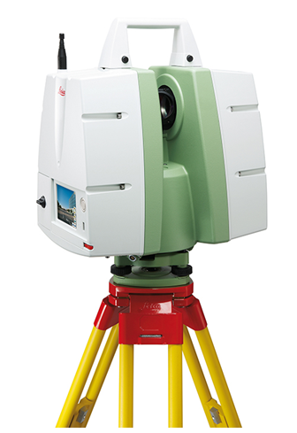
The power of laser scanning

Laser scanning is the surveying technology of choice when it comes to difficult environments.  Historic buildings, exterior elevations, heavy MEP conditions and the need for very precise measurement data capture are all examples of when laser scanning technology should be used.


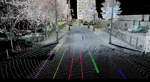
Laser scanning generates millions of data points to create a 3D image referred to as a “point cloud.” The point cloud can be measured and viewed in any direction, which virtually puts you back at the work site.


The point cloud is then utilized to generate AutoCAD drawings, building information models (BIM), or used as a design tool itself.


The speed of laser measuring

Our advanced laser measuring technology allows for exact measurements and real time data capture of critical data and building geometry. The use of wireless laser range finders and a remote BIM workstation reduces data collection time, increases accuracy and eliminates rework.


Models and AutoCAD files can be generated onsite and in real time, as well as quality control and field verification, which greatly reduces the amount of work required back in the office.


Here are just a few examples of how laser scanning and measuring have provided more accurate information while saving valuable time and resources in the field:


Project Case Study: Historic Hotel Renovation

A historic hotel built in the 1930’s with no existing documents and in a bad state of disrepair was scheduled to be renovated into a modern boutique hotel. 


LandAir utilized both 3D laser scanning and laser measuring technology to provide a point cloud, TruView, fly-through video and AutoCAD drawings. Laser scans were performed on the exterior of the hotel to provide elevation drawings. 


The eight-story hotel’s exterior was brick and adorned with many architectural details. The laser scan was able to capture all of the exterior data measurements and provide additional helpful details that were viewed in the point cloud including sidewalks, tree clearances and parking lot details. 


The laser scan was continued into the lobby and through the first floor of the hotel, helping tie together the laser scan information and laser measuring software. Due to the nature of the construction of the hotel, each one of the over 140 rooms had to be individually measured and floor plan documents created. 


With LandAir’s workflow design and remote BIM workstation, QA/QC was able to be done on the rooms in the field and the irregularly shaped rooms were verified on site.


Project Case Study: Big Box Retail Conversion

A grocery store and two adjacent in-line stores had gone dark and were going to be renovated to accommodate a new tenant. The option on the building was expiring and there were no existing documents to help determine if the space would work for the future tenant. 


LandAir utilized laser measuring technology to provide AutoCAD documents and a 3D model to the designer and tenant in less than two days. The proposed design and tenant requirements were compared to existing conditions and the project was able to move forward in the required timeframe.


Project Case Study: Pedestrian Bridge Addition

A pedestrian bridge was proposed to be built over an extremely busy street in a large Metropolitan downtown connecting a hotel and parking deck. No drawings were available and the proposed bridge was four stories above the street, making traditional measuring very difficult and dangerous. 


LandAir conducted a 3D laser scan of the exterior of the hotel and the existing parking deck.  The street scape conditions, power lines, traffic signals and building tie-in points were all measured accurately and safely from the laser scanner. 


AutoCAD drawings, a TruView and a video fly-through were provided for the project team. The point cloud fly-through provided a 3D visualization from any vantage point of the proposed bridge.


This helped the hotel determine how the sight views of rooms would be affected and allowed for inspectors, DOT officials and the downtown development authority to understand the impact of the proposed bridge. 


Project Case Study: Mall and Food Court Renovation

A three-story open atrium food court was to be redesigned and new tenants added to the mix. 


The existing documents were not a true representation of existing conditions as, over the years, there had been changes and alterations to the space. Additionally, the height and design of the atrium had many features that were difficult to measure.


LandAir laser scanned the atrium and surrounding spaces to provide a 3D model and clash detection for the proposed design changes. Laser measuring was also utilized to produce exact as-built documents for the surrounding spaces so that the mall owner could provide drawings for future tenants to build out their stores.


Each project has its own challenges and needs. LandAir uses the latest laser technologies to improve these projects and put an end to one of the most painstaking tasks in construction: field measuring. Are you planning to attend ICSC RECon 2013 in Las Vegas next month? If so, e-mail me at mdorsett@lasurveying.com. We would love to meet you there!

###


Mitch Dorsett has over 15 years in the building and construction industry and serves as director of business development for LandAir Surveying. Mitch is rapidly becoming an expert in 3D data capture and virtual design and construction, having attended and represented LandAir’s laser scanning capabilities at SPAR, RTC and Autodesk University in 2012. Contact him at mdorsett@lasurveying.com or visit www.landairsurveying.com

3D Laser Scanning Saves Busy Airports Big Bucks

We love airports here at LandAir Surveying – and airports love us, too! Airport managers need quality data quickly and with minimal intrusion, which are core strengths of 3D laser scanning.

Learn how we have been able to save big bucks for some of the country’s largest and busiest airports with 3D laser scanning…

Clash detection

3D laser scanning adds a lot of value to construction and remodeling projects inside airports, which are large, complicated facilities. Utilities, baggage handlers, human conveyors, escalators, and other features are closely packed together, making it impractical and expensive for architects and engineers to measure every feature individually (which would be subject to human error, anyway).

Conversely, 3D laser scanning does not miss important details and delivers an excellent asbuilt on a consistent basis.

Once scanned, we can perform a “clash detection” analysis by comparing the existing facilities to the new proposed design. In airport projects, often some existing features will have to be removed, whether temporarily or permanently, so we look for features from the asbuilt and new design that want to occupy the same space.

Using this technique, architects, engineers, and contractors can essentially “test” the new design against real conditions before construction begins. Contractors can easily see unexpected interferences and save money budgeted to fix these unknown “clashes.”

One of the biggest airport projects we have done recently was in Hartsfield-Jackson Atlanta International Airport. The client wanted to build a luggage conveyor through an existing portion of the airport. In this video of our scan, you can see that our software has painted all of the areas that clashed red, making them easily visible.

In our scan, we found that an unknown structural column was located in the center of the new proposed conveyor. The general contractor was able to save our fee and much more by identifying these interferences in the design phase rather than paying for them in the construction phase. Ultimately, our services more than paid for themselves.

Minimal intrusion

3D laser scanning also has the advantage of being minimally intrusive to patrons of the airport.  On top of being significantly faster than traditional surveying, the scanning process is much less obvious.

The scanner uses light reflected from any given surface without the need for another worker to hold a rod or mirror on the object being located.

For example, the airport in San Francisco needed an asbuilt of its luggage handling system, but this required data from the area where travelers actually picked up their luggage. With 3D laser scanning, we were able to collect the necessary data quickly and efficiently. Most of the patrons had no idea that they were even in an area being scanned.

Shorter runway shutdown times

3D laser scanning may lend itself even more to scanning an airport’s outside facilities.

When a runway has to be redesigned, it must often be resurveyed to account for settlement and movement. Survey crews must be able to locate the existing pavement, lights, striping, etc. Depending on the runway, this can take several weeks with traditional surveying methods and requires the runway to be closed.

With 3D laser scanning, data is collected in less than half the time. Plus, every square foot of the runway is captured as opposed to the traditional 25-foot grid. Airports face reduced runway shutdown time and our field crews are safer. It’s a true win-win scenario.

For example, one regional airport in Southeast Georgia needed to resurface its runway. They needed topographic data accurate to within ¼-inch and they needed it fast. We provided a scanning crew to quickly collect the data and delivered the project with the required accuracy within their required timeframe.

3D laser scanning’s ability to capture the entire runway can lead to the creation of more accurate glide slopes, which are the paths used by airplanes approaching the landing strip. We provided this service to Lockheed at the Dobbins Air Force Base in Marietta, Georgia.

Unlimited applications

There are many other applications for 3D laser scanning in and around airports. Recently, we had the opportunity to do a somewhat unusual scan for an airport in Arkansas.

Developers were planning to build hotels and other commercial properties around and adjacent to the airport property. However, several decades ago, large underground storm drains were installed through the proposed property with limited record of where these pipes existed.

We were able to use 3D laser scanning to determine the location, size, and dimensions of these storm pipes.

It was a tight squeeze, but our crew traversed through all the storm pipes from the river outlet through to the runway. The contractors learned where the pipes were, engineers learned their locations and storm water capacities, and the owner gained valuable information about its assets. 3D laser scanning benefitted everyone involved.

###

David Headrick has over 20 years of experience in the surveying, engineering and legal industries, both as a project manager for LandAir Surveying and as a lawyer in private practice. He has represented numerous land surveyors, designers, architects, contractors and other industry professionals throughout his career. Today, David serves as an executive and project manager for LandAir, focused on developing and managing the company’s 3D Laser Scanning department. Contact him at dheadrick@lasurveying.com.

Going to SPAR International?

We are getting ready for the SPAR Point Group’s 10th annual conference “End to End 3D: Capture, Process, Deliver” in Colorado Springs, Colorado, April 15-18. This is the main event of the year for people in the 3D laser scanning business.

For starters, every manufacturer and software developer in the 3D laser scanning world is sponsoring the event and will be in attendance. We can expect to be dazzled by live demonstrations of the latest and greatest scanners, software, and technology. If you haven’t heard, many announcements have been made in the past few months about breakthroughs, innovations, and technological advancements.

The conference will also be a comprehensive educational opportunity with lots of classes and workshops. Just about every aspect of 3D laser scanning will be presented and discussed.

Attendees can also choose to concentrate on one of the offered tracks: Industrial Facilities, New Technologies, Civil Infrastructure, and Forensic & Security. We will try to check out some of them all. Please let us know if there is a specific topic you would like us to look into. After all, if you need it, we need to know about it!

The topics listed on the website include 3D laser scanning, structured light, LiDAR, photogrammetry, reverse engineering, 3D/4D GIS, Kinect, indoor/portable mapping, autonomous vehicles, mobile survey, point cloud processing, airborne LiDAR /terrestrial integration, open source, web sharing, VIM, augmented reality, 3D printing, simulation, and visualization.

Did I mention that one of the keynote speakers will be Michael Jones, chief technology advocate for Google? That one will certainly be well attended.

With all of these events, we just hope to be able to enjoy a little of Colorado Springs and the stunning Broadmoor Resort that is hosting the conference. Hopefully, we’ll get some better Spring weather!

###

David Headrick has over 20 years of experience in the surveying, engineering and legal industries, both as a project manager for LandAir Surveying and as a lawyer in private practice. He has represented numerous land surveyors, designers, architects, contractors and other industry professionals throughout his career. Today, David serves as an executive and project manager for LandAir, focused on developing and managing the company’s 3D Laser Scanning department. Contact him at dheadrick@lasurveying.com.

How 3D laser scanning keeps us safe…

All of the hype over 3D laser scanning often glosses over another critical advantage it has over traditional land surveying: safety.

When asked to go out and procure data, we land surveyors must go where the data is and some of these places can be very dangerous. With 3D laser scanning, data can be collected faster and less intrusively than ever before, keeping our field crews out of harm’s way.

Think about it: where do you typically see land surveyors? On the side of the road!

Roads are frequently included in all manners of land surveying. They can be boundaries for property or serve as access to new commercial developments. For surveyors who work for the Department of Transportation, their whole job could be comprised of roads.

We all know that pedestrians have the right-of-way, but anyone who has crossed a busy highway can vouch for the fact that cars and trucks rule the road. Anything that limits the amount of time our field crews stand on roads ultimately makes our jobs safer.

3D laser scanning improves safety in two ways. First, it significantly decreases the amount of time surveyors have to be out in the field. When fieldwork can be completed with less instrument set-ups, field crews spend less time standing on bridges, highway abutments and railroad tracks.

Second, since 3D laser scanning uses light to collect data without the requirement of a reflective mirror held by a rodman, field crews do not have to physically occupy every point that they collect. These points can be located after the data goes back to the office.

This keeps field crews from having to locate such features as road striping, small medians between busy roads, concrete highway barriers and railroad trestles.

There are plenty of other less common examples. For instance, if a building is unstable, such as after a fire or structural failure, 3D laser scanning allows the data to be collected from a distance.

Similarly, when it is necessary to locate rough geography like a steep slope or cliff face, 3D laser scanning can negate the need for fall protection equipment. This is even more true when it is necessary to locate unstable slopes and landslides.

So, while it’s great to talk about the fact that 3D laser scanning brings home more data at a higher quality than ever before, we also truly value that it’s keeping our people safe.

###

David Headrick has over 20 years of experience in the surveying, engineering and legal industries, both as a project manager for LandAir Surveying and as a lawyer in private practice. He has represented numerous land surveyors, designers, architects, contractors and other industry professionals throughout his career. Today, David serves as an executive and project manager for LandAir, focused on developing and managing the company’s 3D Laser Scanning department. Contact him at dheadrick@lasurveying.com.


A Hidden Place Where Laser Scanning Provides High Value

If you think laser scanning provides a substantial amount of value for aerial and terrestrial projects, just wait until you hear about the benefits of taking it here. Click here to check out Tate’s featured blog on GeoDataPoint.com…

Hotel and Casino Markets Bring Big Opportunities for 3D Laser Surveys

It looks like 2013 will be a banner year for the hospitality industry.

In 2012, U.S. hoteliers collectively sold more than 1.1 billion rooms. Las Vegas welcomed a record 40 million visitors last year and nationwide commercial gambling revenues surpassed the $35.6 billion mark in 2011, up from $34.6 billion in 2010.

A recent study released by the American Gaming Association (AGA) reports that the commercial casino industry supported approximately $125 billion in spending and nearly 820,000 jobs in the U.S. economy in 2010, based on direct, indirect and induced impacts.

Though development, funding, business travel, convention participation and disposable income were almost non-existent over the last five years, the hospitality industry is making a comeback.

So, what does all of this mean to the construction industry? How can the AEC community, which has struggled for years, take advantage of this opportunity?

It already is. The number of projects in the pipeline has already greatly increased during the first two months of 2013 over the first two months of 2012. The AIA reports that the Architecture Billings Index (ABI) is reflecting its strongest growth since November 2007.

Not only is the number of new ground-up projects increasing, but renovations and expansions are also happening at a record pace.

Hotels and resorts are expanding, updating rooms, adding new restaurants, providing more services and implementing property improvement plans (PIP) that have been on hold.

As a result of all of this construction, we have seen a tremendous surge in the need for accurate as-built documentation from owners, designers, engineers and contractors.

They need to know what they have and they need to know fast – and 3D laser scanning and measuring services are in high demand.

In just the past few months, our firm has completed a wide variety of projects and requests including field measuring and verification of rooms, hallways and common areas; documentation of exterior elevations and connect points for building expansions, theatres, meeting spaces and parking decks; and complete renovations of old hotels or buildings being transformed into new facilities.

Here are just a few examples of some of our recent projects:

Hotel Renovation

We provided as-built documentation for common areas, hallways and over 100 interior rooms in a major hotel renovation project using laser scanning and laser measuring to produce AutoCAD documents and 3D models.

Rather than measuring each space then returning to the office to create documents, we utilized our laser data capture techniques to wirelessly import to a BIM workstation. This allowed us to measure and create 3D models and AutoCAD files on site and in real time.

We were able to generate floor plans, reflected ceiling plans and interior elevations in the field, which led to increased accuracy, reduced collection and drafting time, and eliminated the need for return visits.

The architect was able to begin work on floor plans immediately while we continued to measure additional floors.

Mechanical Room Boiler/Chiller Replacement

We generated a 3D laser scan of a 20,000 square foot mechanical room, providing a level of accuracy and detail that would have been unattainable with traditional measuring techniques due to the amount of heavy piping and ductwork required.

This enabled designers to drop their prospective model into the point cloud and determine clash issues and tie-in points. The laser scan saved field rework time, material costs and allowed enhanced coordination amongst the project team.

Casino Theater Addition

Because there was insufficient data on the existing condition of the space targeted for the design of a theater, we provided a point cloud and TruView to the contractor and design team via a 3D laser scan. The point cloud allowed for existing mechanical systems and structural elements to be measured and inventoried.

The results increased the speed of design, reduced cost of materials and field rework, assisted with developing a safety plan, and increased collaboration efforts between team members.

As the hospitality industry continues to expand, the demand for 3D laser surveying will increase as clients search for ways to save time and money on their construction and renovation projects. You can bet on it!

###

Mitch Dorsett has over 15 years in the building and construction industry and serves as director of business development for LandAir Surveying. Mitch is rapidly becoming an expert in 3D data capture and virtual design and construction, having attended and represented LandAir’s laser scanning capabilities at SPAR, RTC and Autodesk University in 2012. Contact him at mdorsett@lasurveying.com or visit www.landairsurveying.com

BIM: Breakfast of Champions

Whenever my travel and work schedules allow, I try to attend the BIM Breakfasts at Georgia Tech.

Held once a month on the Georgia Tech campus, the breakfast brings together some of the best and brightest minds in the Atlanta area.

The February event featured speaker James Barrett, the national director of integrated building solutions for Turner Construction. Jim specializes in virtual design and construction/Building Information Modeling (BIM) technologies, lean processes, and integrated project delivery.

Put in layman’s terms, he is pushing BIM and virtual design tools to the limit. Under his leadership, Turner Construction has become one of the top BIM users in the world.

Jim does not push BIM just because it’s BIM. His idea is that his designers and contractors need to use the best tools available to help their company succeed and their clients get the best results. The BIM process and virtual design flows naturally from that core idea.

Turner also does not push one specific type of software, but instead teaches as many as 10 or 12 different packages that their best and brightest have become familiar with. As with any tool, Jim explains, no one tool will do everything.

Another point he made was this: when you roll out a new technology, don’t try to convince the world that it’s the best way to go. Instead, show it to the early adopters and let them prove that it works and that it’s the most efficient option. It will naturally make its way to other potential users.

For me, this point really hit home.

In 2005, we began using terrestrial lidar and 3D scanning technology. I have traveled to many firms in the southeast and tried to sell the benefits to the whole AEC community.

Initially, I had minimum success. It was early in the process and few of the established firms were interested at that time. However, I did find a few and slowly built a successful 3D laser scanning division that still thrives today.

These firms were the early adopters. Ironically, it was not always the young guys that were the most open to new ideas. Sometimes it was an older person who could see like I did where this technology was headed.

Now this technology is almost mainstream and is an integral part of the BIM process.

In his presentation, Jim pointed out that in New York City they have “view protection” and laser scans are used to document the view of the construction site.

In the BIM toolbox, when you identify a complicated project, laser scanning is a tool that you should certainly consider. The benefits and uses of laser scanning data are numerous and the risk of not using one and incurring additional costs down the road can be significant.

Another really good idea that Jim presented was that every year, they take a small percentage of their new hires and immerse them into what they call BIM University.

These people then become experts that the rest of the company can learn from. This gives every group in the company and geographic area internal experts that they can lean on to best implement the technologies of BIM. What a great idea!

They even started an intra-company communication site on their intranet so that users anywhere in the company can post a question. In minutes, experts throughout the company can provide insights and answers and have a forum to share their knowledge.

I believe this practice will continue to grow as companies see the value of tapping into the knowledge base they already have with their employees. What a great tool for a leader to build in their own company.

Jim’s presentation also touched on the other tools that help to automate the construction and design process like the ability to view augmented reality on iPads with the use of QR codes. At his firm, they work with public inspectors to load iPads with plans and drawings to make their process quicker and more efficient.

He also addressed the effect that 3D printing will have on the construction industry. Though it will not likely take the place of massive building material needs, it will fill a unique need when a limited number of items are needed in a quantity that can be met with industrial 3D printers, he said.

There will always be people who question whether we need BIM and virtual design and construction. I cannot completely understand why anyone in the AEC industry would still be asking this question, but I do understand that in some subsets, there is much more low-hanging fruit than in others and for these, early adoption is a no brainer.

The push for BIM and virtual design use and innovation is coming out of the construction industry as the large GC firms have pushed it further and further into their processes.

If you are in the Atlanta area and want to see and meet some of the best minds in BIM, I do recommend the Georgia Tech BIM Breakfast forum. Every time I go, I learn something.

###

Tate Jones has over 40 years of experience in land and aerial surveying and was one of the country’s earliest adopters of 3D laser scanning technology. A nationally recognized expert in the field of 3D data capture, he has worked with hundreds of clients in the engineering, architectural and construction industries. Contact him at tjones@lasurveying.com or visit www.landairsurveying.com.

3D Laser Scanning gives law enforcement the upper hand in crime scene investigation and recreation

In October 2011, police responded to a grisly double-murder in Rocky Face, Georgia.

An elderly gentleman and a teenage girl were found dead from gunshot wounds to the head. The scene was even more revolting because the murderer had tried to cover his tracks by setting the house on fire.

What did the Georgia Bureau of Investigation use to document this complicated crime scene? They used 3D laser scanning. According to GBI Special Agent Jerry Scott, “It’s now the best technology available for documenting and recording crime scenes.”

Collecting evidence

3D Laser Scanning is quicker than other types of crime scene documentation and the technology provides much more useful data, making crime scene reconstruction more accurate, reliable, and easier to explain to a jury.

Police generally use the Leica C-10 as their scanner of choice. This instrument can take 84 pictures in about six minutes and measure from up to 200 feet away. With this capability, crime scene documentation can take up to 80% less time.

What does is record? Well, everything.

“Where the cars were, where the debris ended up, where the body was, where the weapon was – anything seen by the scanner, we will have,” said Sgt. Jeff Davis from the Arlington, Texas Police Department to WFAA in Dallas.

3D laser scanning is increasingly finding its home in other police forces across the country.

“It has become a standard part of our initial investigation process,” said Chattanooga Police Sgt. Darrell Whitfield, who was the first Chattanooga police investigator to train with the equipment.

Lieutenant Matt Magro of the Carlsbad, California Police Department told the news in San Diego, “It allows us to recreate the scene very quickly and very accurately. You can click on the bullet hole on the wall and then go to the shell casing and it will tell you what the distance between those objects is and the elevation in just the click of a mouse.”

During the investigation

Once the site is cleaned up or altered in any way, the evidence is spoiled. However, 3D laser scanning allows investigators to return to the site at any time to retrieve missed or forgotten details. Investigators can view vivid color 3D data and extract any measurement they need long after the scene has been released.

At the crime scene, investigators take photographs, make measurements and sketches, and interview witnesses. However, even the most seasoned investigator can miss critical details due to time constraints, site access, or simple knowledge of the facts.

Sgt. Davis noted that having access to the scene as it was days, months, or even years after is extremely valuable. “If something comes up later, then we are able to go back to the scan and extract that information.”

As a case develops, investigators can use the 3D scan to determine which “witnesses” could really see what happened. When a gun is involved, for example, built-in shooting reconstruction tools can zero in on probable shooter locations.

Using the data at trial

3D laser scanning has also become a game-changer in court.

“It gives juries a virtual tour of the crime scene,” said Iredell County, North Carolina Sheriff’s Chief Deputy Rick Dowdle in the Moorsville Tribune.

Traditionally, the jury is shown a series of photographs and two dimensional diagrams of the scene. This requires a great deal of explanation and imagination on the part of the jury.

It is also an answer to what Hamilton County District Attorney Bill Cox calls the “‘CSI effect” among modern jurors, many of whom consume a steady diet of crime and courtroom dramas.

“People watch television and they expect a lot of high-tech video and audio evidence,” Cox said in a recent interview.

As noted by Lt. Warren Hamlin of the Knox County Tennessee Police Department in an interview related to a murder trial in Tennessee, “It’s almost like taking the jury right to the crime scene. We can show pictures all day long, but when you’ve got a panoramic view that shows exactly how it looked and where everything was, that’s a much better depiction than a photograph. So, if a guy says, ‘I was standing in that corner,’ you can create a viewpoint exactly where his head would be and look around the model and tell whether yes, he could see that, or, no, he’s lying.”

The truth is that law enforcement is developing a tool to cut its investigation time and dramatically improve its effectiveness both during the investigation and in court. Defense attorneys had better start catching up.

###

David Headrick has over 20 years of experience in the surveying, engineering and legal industries, both as a project manager for LandAir Surveying and as a lawyer in private practice. He has represented numerous land surveyors, designers, architects, contractors and other industry professionals throughout his career. Today, David serves as an executive and project manager for LandAir, focused on developing and managing the company’s 3D Laser Scanning department. Contact him at dheadrick@lasurveying.com.

Sources:

Double murder victims shot in the head before suspect set house on fire (located at http://www.wrcbtv.com/story/15499351/north-georgia-double-murder-victims-shot-in-the-head-before?clienttype=printable)

Georgia Bureau of Investigation agents train with 3-D laser scanners in Dalton (located at http://www.timesfreepress.com/news/2012/jan/22/crime-scene-science-gbi-agents-train-with-3-d/)

High-tech scanning system keeps record of scenes for Arlington PD (located at http://www.wfaa.com/news/crime/High-Tech-System–Scanning-Incidents-in-Arlington–171642511.html)

Laser scanning system enables CPD to reproduce 3D crime scene (http://www.timesfreepress.com/news/2011/nov/06/laser-scanning-system-enables-jurors-reproduce-3d-/)

Revolutionizing Crime Documenting Tool (located at http://www.sandiego6.com/news/local/Revolutionizing-Crime-Documenting-Tool-183033771.html)

Five reasons to consider laser scanning in 2013…

Blog 5 photo c10 scannerI hope you are off to a wonderful New Year! In the theme of the New Year, I continue to be amazed at all of the new applications for laser scanning that our clients are coming up with or projects they inquire about measuring.

Hopefully this blog will inspire you to think of opportunities to utilize our services in 2013 to make your next project even better.

As-built data capture has always been a challenge for the AEC community and owners of assets. The outdated methods of gathering data are time consuming and lack accuracy and utilizing these record drawings can be inexact.

LandAir Surveying uses the latest technologies to help our clients. Whether you are looking for accurate as-built floor plans, historic preservation of a structure or MEP surveys in the plenum of a ceiling, we have an accurate and cost-effective solution for you.

Over eight years ago, we began utilizing the revolutionary technology of laser scanning. Our first laser scans were for the transportation industry, performing bridge surveys. Through these and other projects, we found laser scanning to be superior to traditional methods of data capture for a number of reasons:

#1: They are more precise.

A laser scan takes multiple scans to collect millions of data points. These scans are then registered together to generate a single three-dimensional “point cloud” that can be measured accurately and provides distances and elevations between points on X, Y & Z coordinates.

#2: They are versatile.

Laser scans can produce (when used with digital color photos) survey quality files, fly-through videos, BIM Models and CAD drawings.

#3: They are fast.

A single laser scan can be collected in around six to eight minutes. This enables crews to take many more scans and capture more detailed data than ever before. It also allows for accurate surveys to be done with minimal interruption to building occupants.

#4: They are safe.

Laser scanning provides a safer environment and allows crews to measure in places that would have previously been impossible.

#5: They save you money!

Finally, laser scanning almost always pays for itself. Here are a few examples of ways laser scans can save you money on your next project. Here are a few examples of ways laser scans can save you money on your next project:

  • You can always revisit the original scan multiple times from your computer desktop without the time and expense of traveling to the site again and again. With a laser scan, you can even revisit the site from your desktop years after the initial scan.
  • The quality of data collected can minimize or eliminate the need for construction reworks and field retrofitting.
  • The number of change orders due to erroneous design and unknowns in the field are dramatically reduced.
  • Material waste is reduced and the amount of production in the shop is increased.
  • Coordination between design and construction teams is greatly improved by providing visual documentation for discussion.
  • The speed of design is increased by providing accurate as-built conditions and clash detection.
  • Bid documents can be created from as-built data, resulting in lower-priced bids and a quicker schedule.

As you can see, the reasons for laser scanning are compelling. But what types of projects are best suited for this technology? In our experience, we have seen the greatest return on investment for laser scanning on projects that are complex and difficult to measure. Those projects with precise measurement requirements and a required speed of data gathering typically yield the greatest return on investment.

We have scanned miles of tunnels, airport conveyor systems, MEP structures that look like pipe “spaghetti,” hotel and casino atriums, and theaters and stadium grandstands with thousands of different sized structural beams. Laser scanning was by far the best solution for these projects.

While complex projects are great opportunities to utilize laser scanning technology, other advances in virtual design and construction solutions have allowed us to provide results for less complex environments.

New software and measuring solutions allow us to provide detailed as-built drawings and 3D models for hotel rooms, retail spaces, classrooms and offices with amazing speed and at a greatly reduced cost-per-square-foot over traditional architectural surveys. Field measurements to productions of floor plans and even Revit models can now be delivered in days.

From the industrial, manufacturing and energy sectors to hotels, hospitals and retail spaces – LandAir can provide solutions to make your next project more efficient and affordable.

###

Mitch Dorsett has over 15 years in the building and construction industry and serves as director of business development for LandAir Surveying. Mitch is rapidly becoming an expert in 3D data capture and virtual design and construction, having attended and represented LandAir’s laser scanning capabilities at SPAR, RTC and Autodesk University in 2012. Contact him at mdorsett@lasurveying.com or visit www.landairsurveying.com.

3D Laser Scanning

Advances in 3D data capture are changing faster than ever. How can we help you in 2013?

First, let me say Happy New Year to all of our clients who have supported us for the past 25 years. We appreciate you and are honored that you choose LandAir Surveying to team with you on many interesting projects across America.

Over the past seven years of traveling down the road of 3D data capture and using multiple platforms for LiDAR data collection, we have seen this technology expand into almost every field of design, construction and manufacturing.

It has been fascinating to watch the world change from 2D plans to 3D data sets and models. And in the process, modeling is becoming cheaper, faster and easier.

Having attended international conferences and through speaking to groups across the country, we have seen and studied with interest what is going on in the U.S., Europe, Japan, India and Asia. The whole world of design and construction is making this shift!

Daily, we talk with firms both domestically and internationally about the diverse issues of 3D design and construction to equip us with the knowledge we need to be your trusted resource for new approaches to surveying projects.

For example, we have been producing surveys for the transportation industry since 1998. I can remember when we had to actually put our surveyors out in traffic (with approved safety measures, of course). Now, with our scanners, we can stay off the shoulder of the road and capture all the required data without putting anyone in harm’s way. This is standard practice now and, as an owner of a surveying company, very important to me personally.

Approaches to projects are changing not only in transportation, but across all industries.

Last year, we produced a 400-acre topographic map with 1-inch contours in very, very dense foliage. Just two years ago, we would have had to field survey this project. But by using a combination of aerial LiDAR and strategic surveying techniques, we were able to produce the job at 1/3 the cost of a traditional field run survey.

In 2013, we plan to expand our technology, using drones to capture data on specific projects. This is already being done across the country and the technology is moving from military grade and unaffordable to civilian grade and absolutely affordable.

So, how can we help you this year? For one, we can show you how surveying tools are changing and getting better. We can discuss with you when to use airborne LiDAR to document and produce data over a city, county or state.

We can show you when the conditions are right to use mobile LiDAR and put together a team to make your project successful.

We know when to use helicopter platforms for LiDAR over fixed wing aircraft, and we can show you how to model the inside of an existing building faster and more cost effectively than ever before.

We look forward to being a valuable resource for your firm and hope to continue working with you in 2013 and beyond. The design world is changing very fast and we are committed to changing right along with it.

Have a great and profitable 2013!

###

Tate Jones has over 40 years of experience in land and aerial surveying and was one of the country’s earliest adopters of 3D laser scanning technology. A nationally recognized expert in the field of 3D data capture, he has worked with hundreds of clients in the engineering, architectural and construction industries. Contact him at tjones@lasurveying.com or visit www.landairsurveying.com.