Posts

3D Laser Scanning

Advances in 3D data capture are changing faster than ever. How can we help you in 2013?

First, let me say Happy New Year to all of our clients who have supported us for the past 25 years. We appreciate you and are honored that you choose LandAir Surveying to team with you on many interesting projects across America.

Over the past seven years of traveling down the road of 3D data capture and using multiple platforms for LiDAR data collection, we have seen this technology expand into almost every field of design, construction and manufacturing.

It has been fascinating to watch the world change from 2D plans to 3D data sets and models. And in the process, modeling is becoming cheaper, faster and easier.

Having attended international conferences and through speaking to groups across the country, we have seen and studied with interest what is going on in the U.S., Europe, Japan, India and Asia. The whole world of design and construction is making this shift!

Daily, we talk with firms both domestically and internationally about the diverse issues of 3D design and construction to equip us with the knowledge we need to be your trusted resource for new approaches to surveying projects.

For example, we have been producing surveys for the transportation industry since 1998. I can remember when we had to actually put our surveyors out in traffic (with approved safety measures, of course). Now, with our scanners, we can stay off the shoulder of the road and capture all the required data without putting anyone in harm’s way. This is standard practice now and, as an owner of a surveying company, very important to me personally.

Approaches to projects are changing not only in transportation, but across all industries.

Last year, we produced a 400-acre topographic map with 1-inch contours in very, very dense foliage. Just two years ago, we would have had to field survey this project. But by using a combination of aerial LiDAR and strategic surveying techniques, we were able to produce the job at 1/3 the cost of a traditional field run survey.

In 2013, we plan to expand our technology, using drones to capture data on specific projects. This is already being done across the country and the technology is moving from military grade and unaffordable to civilian grade and absolutely affordable.

So, how can we help you this year? For one, we can show you how surveying tools are changing and getting better. We can discuss with you when to use airborne LiDAR to document and produce data over a city, county or state.

We can show you when the conditions are right to use mobile LiDAR and put together a team to make your project successful.

We know when to use helicopter platforms for LiDAR over fixed wing aircraft, and we can show you how to model the inside of an existing building faster and more cost effectively than ever before.

We look forward to being a valuable resource for your firm and hope to continue working with you in 2013 and beyond. The design world is changing very fast and we are committed to changing right along with it.

Have a great and profitable 2013!

###

Tate Jones has over 40 years of experience in land and aerial surveying and was one of the country’s earliest adopters of 3D laser scanning technology. A nationally recognized expert in the field of 3D data capture, he has worked with hundreds of clients in the engineering, architectural and construction industries. Contact him at tjones@lasurveying.com or visit www.landairsurveying.com.

Autodesk University 2012: watching an industry grow up!

Attending and exhibiting at shows like Hexagon, Spar, and Autodesk University is always fascinating because you get to interact with clients all over the country and see what’s new in the industry.

This was our first time exhibiting at Autodesk University, but having been to three conferences in Las Vegas in one year, I was quite familiar with the surroundings. At this year’s show – which was attended by over 8,000 people from 102 countries – what I saw was an industry that has grown up and is beginning to make a real impact on design and construction.

I remember in 1986 when a new drafting program named AutoCad came out and everybody was debating if it would become the standard…it did. And it brought with it – along with the digital age and computers – the plotters and all that went with the introduction of this new paradigm.

Most of us waited to see how it would be received in the industry, but then – as now – it proved to be a very valuable tool.

And just a few years ago, we were all still discussing the advances in AutoCAD and Civil 3D.  Though we knew these programs would remain relevant, it was evident from all of the different software that interacted inside of Revit and enhanced the user experience that the world of 3D design was here to stay. (As a friend of mine said not long ago, “If you are not designing and interacting in 3D and models, you are quickly going to be obsolete.”)

Autodesk University 2012 showed us how design is being done today and where it is going in the future. One of the more interesting observations was that besides the architects, engineers and designers, there were contracting companies, retail companies and owners all talking about the new Autodesk programs that were being used in the workplace.

There was lots of talk in these groups about building “Revit families” specific to their business types, as well as discussions around how to mix the contractors (who have the knowledge about how a building is built in the actual world) with the BIM modelers so that the models are also constructible.

This will be a big challenge. Contractors and superintendents who know how to pour a slab and build 20-story buildings have knowledge and insight that is absolutely critical to building a proper BIM model.

As any techno geek, I am always very interested in the new products on the exhibition floor and the showcase included hundreds of third-party vendors developing exciting products that work alongside Autodesk.

There were lots of new software and hardware lines in the 3D laser scanning industry, as well as new software offerings for BIM models, Revit technologies and GIS products. But for me, the most intriguing products were related to 3D printing applications.

These fabrication and modeling solutions enable products to be created directly from their computer models.

Almost anything you could imagine – from cars to motors to guitars – was printed and on display. Though 3D printing has been a popular topic in recent years, it was there, it was real, and it will definitely change how items are built in America and around the world.

At the conference in Vegas, there were actual printers producing objects out of wood, metal and polymers. The only difference was whether the printer was loaded with plywood or metal.

BIM is an acronym for Build Information Models, meaning to build computer models that have built-in intelligence. What I observed was BIM in the context above – building models and objects with just the information in a computer.

My, how we have grown.

###

Tate Jones has over 40 years of experience in land and aerial surveying and was one of the country’s earliest adopters of 3D laser scanning technology. A nationally recognized expert in the field of 3D data capture, he has worked with hundreds of clients in the engineering, architectural and construction industries. Contact him at tjones@lasurveying.com or visit www.landairsurveying.com.

Where we are now…and where we’re going.

As 2012 winds down and we get ready to head to Las Vegas for the Autodesk University conference, I look back at the strides that have been made in the 3D world and all of the associated hardware and software in our industry.

Not only is there new technology being used and accepted, but the demand for more BIM products, users, and technologists has grown faster than ever. I have also watched with great interest the wave of corporate acceptance that was not there even three years ago.

There is still much ground to be broken, but wow – what a year!

New Software

Take software, for example. As I travel around America and talk to user groups and clients, the one thing I am always asked is when will it be easier to model point clouds into usable entities?

There is much research going on to solve this challenge. Though I have no commercial interest in this firm, I believe one of the ones to watch in this space is ClearEdge 3D. Their EdgeWise Plant software is pushing the barriers away for modeling point clouds.

Personally, I believe that within the next three years, this major barrier we face now will be a minor issue and point cloud use will continue to grow and expand.

The other great leap in technology is that most of the major software packages have updated their products to accept point clouds as a layer. This means that most of our clients in the architectural and MEP worlds can now import our point clouds into their design software and greatly enhance their designs.

Just three or four years ago, using point cloud data required modeling and this limited the market to mechanical and structural engineers and various contractors with specialty software.

Today, because all Revit users can import point cloud data, the need to model everything in a scan project has been greatly decreased. This is a big deal! Now, instead of having to pay for an expensive model, end users get all of the benefits of point cloud precision without the associated costs of modeling.

Not to be overlooked, there are still issues that will need to be ironed out in inserting point clouds into design software, but they will be overcome with time.

For example, if you are working in Inventor to model plant process data, it is best if the project is modeled from start to finish in Inventor. Similarly, if it is to be modeled in Revit, it is best that it be modeled from start to finish in Revit. There are no readily available universal translators to move from a model that was created in Cyclone to a model in Revit while keeping the full integrity of the original model.

Though the data itself is globally transferrable, the structure of the models, entities, families and libraries requires more work to be done in this area.

New Hardware

Last year, I predicted that the hardware in our industry was set and that most of the changes would come in the form of software. On this point, I was wrong.

Several changes have occurred that continue to advance the hardware. For example, The Faro Focus 3D has broken the price barrier. Prior to its release, most scanners started around $80,000 and went up to $200,000. The Focus was released at about $50,000 and has caused price adjustments throughout the industry.

I believe this trend will continue and prices will continue to go down. This is both a good and bad thing for the industry. As prices go down, more people with marginal training and experience will begin to use scanners and bad point clouds will become more of a problem.

There is a saying in our industry that “one bad point cloud kills a lot of clients.” Indeed, this is true. I have talked to clients who tried laser scanning nine years ago, had a bad experience, and will not use it again to this day. The problem is not that scanners are getting more affordable, but that there are still no national standards in the industry.

The upside is that with a lower cost competitor, vendors must consider what value their laser scanners bring that others do not.

Cool New Technology

Two things I am really interested in and know will change the playing field moving forward are   aerial drones and augmented reality.

These two technologies are growing fast and have many great uses. A traditional helicopter used to map utilities and large areas generally costs about $25,000 per day. A one-meter drone quadripod, on the other hand, costs about $2,000 per day.

Though there are unique tasks that the smaller one-meter drones can do that the helicopter is currently doing, there are other tasks that the smaller drones can perform that traditional helicopters cannot do. For example, smaller drones can more effectively and safely map underground pipes, mines and tunnels.

Currently, to send two scanner technicians into a tunnel requires about six surface and sub-surface support staff. An unmanned drone with avoidance technology would be a great solution.

Augmented reality and the ability to project 3D images easily and to large groups is available and is changing the whole world of education. A small but growing company, ViziTech USA, is doing very creative and trendsetting work in this area.

This is where the science of 3D technology is repackaged so that the average person can use and understand it. This is a powerful tool and will lead to great changes in many industries and educational processes. For more on augmented reality, read our recent blog post here.

The design and construction of future projects will still require the same basic processes that are required today. But the use of precision data before, during and after construction – and the visual way the data can be viewed – will greatly reduce errors and downtime events.

###

Tate Jones has over 40 years of experience in land and aerial surveying and was one of the country’s earliest adopters of 3D laser scanning technology. A nationally recognized expert in the field of 3D data capture, he has worked with hundreds of clients in the engineering, architectural and construction industries. Contact him at tjones@lasurveying.com or visit www.landairsurveying.com.


3D laser scanning revolutionizes construction site accident investigation and evidence collection

In early October 2012, several construction workers were killed or injured when the Miami Dade College parking garage collapsed like a pancake, trapping a then-unknown number of workers inside (See http://tinyurl.com/9956xae). Some survived, but some did not.

Post-accident site investigation

Since this tragic loss of life, injury, and property damage, lawyers have no doubt already begun what will be expensive and lengthy litigation. The owner, architect, engineer, contractor, subcontractors, construction workers and their families will all play a part.

The evidence may be sifted and sorted for years before any judges or juries hear about what happened on that fateful day.

Ideally, each party would have ample opportunity to investigate the site, take measurements, and form opinions as to what happened. However, this was not an option in Miami.

Workers needed to be freed. The structure’s potential for further collapse endangered all those around it. The owner had a dangerous pile of rubble where a new parking garage was supposed to stand. Certainly, nobody wanted to preserve site conditions for any length of time.

So, how can evidence of existing site conditions be preserved forever? 3D laser scanners were dispatched to the site immediately.

From onsite scan to a 3D model on your computer

Similar to traditional surveying, 3D laser scanners are set-up on tripods and use light to precisely measure their surroundings. But whereas traditional land surveying instruments take only one measurement at a time and need a reflector to return the light, 3D laser scanners take millions of measurements of everything that they can “see”  within 300 feet.

This data is collected in a matter of minutes and the instrument can be set up as many times as necessary to see the entire site. Technicians then convert this raw information into a 3D model.

Lawyers and their experts can use this model to return to the day of the accident at any time.  They can pan and zoom around the model to find any desired vantage point. Any angle or distance can be measured and re-measured.

Collecting quality evidence

After any given construction accident, investigators take photographs, make measurements and sketches, and interview witnesses.  However, even the most seasoned investigator can miss critical details due to time constraints, site access, or simple knowledge of the facts.

Once the site is cleaned up or altered in any way, the evidence is spoiled. However, 3D laser scanning allows investigators to return to the site at any time to retrieve missed or forgotten details.

Additionally, the evidentiary quality of 3D laser scanning data far outweighs traditionally collected evidence. Photographs provide only a single 2D perspective and each detail must be specifically targeted. Manual measurements are subject to observational and recording error.  Witnesses certainly cannot permanently remember every visible detail, especially in the wake of a tragedy. 3D laser scanning overcomes all of these limitations.

Full access to the site is often limited, for example, from the danger of additional collapse and loose rubble around the parking garage in Miami. This problem is also overcome with 3D laser scanning, as it uses light to measure from a distance. Anything that can be seen can be scanned and recorded for later review.

Using the model at trial

3D laser scans are not new to the courtroom and readily pass muster under evidentiary challenges. Foundation for entering a 3D laser scan on the record can be laid by a professional land surveyor, but courts nationally have allowed scans based on the testimony of laymen who were simply certified to use the equipment.

At trial, 3D laser scans provide unparalleled demonstrative exhibits. Judges and juries will no longer need to travel to visit a site.

As noted by Lt. Warren Hamlin of the Knox County Tennessee Police Department, “It’s almost like taking the jury right to the crime scene. We can show pictures all day long, but when you’ve got a panoramic view that shows exactly how it looked and where everything was, that’s a much better depiction than a photograph. … So, if a guy says, ‘I was standing in that corner,’ you could create a viewpoint exactly where his head would be and look around the model and tell whether, yes, he could see that, or, no, he’s lying.”

###

David Headrick has over 14 years of experience in the surveying, engineering and legal industries, both as a project manager for LandAir Surveying and as a lawyer in private practice. He has represented numerous land surveyors, designers, architects, contractors and other industry professionals throughout his career. Today, David serves as an executive and project manager for LandAir, focused on developing and managing the company’s 3D laser scanning department. Contact him at dheadrick@lasurveying.com.

The Next 3D Scanning Frontier: Transportation BIM and Augmented Reality

As I stand back and look at where 3D laser scanning has led us as a company, I am both pleased and confident that the world of 3D virtual design and engineering is healthy and growing fast.

I recently met some truly amazing people from all over America and Europe who are doing some very forward thinking things with 3D virtual reality in both transportation BIM systems and augmented reality. Here’s a snapshot of what I saw:

Transportation BIM Systems

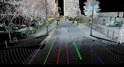
I was in Washington, DC, a few weeks ago speaking at a large corporate meeting and had the opportunity to see a fascinating presentation on the San Francisco Bay Bridge construction.

The construction cost will come in around $7 billion (yes, billion). The metrics are staggering, but there are four major construction firms working on the project.

Cal Trans has scanner crews scanning the progress on a weekly basis. Because of this, there was room in the budget and the available technology to do real time clash detection of the existing and proposed construction.

Because the bridge was designed in 3D (really in 5D), engineers were able to save big bucks on relatively simple components. For example, the 3D scan allowed them to get real time views from the proposed security cameras underneath the bridge. As a result, the actual number of cameras was cut in half, saving several million dollars.

Crews also used 4D (time) clash detection to view when a new component of the bridge was being constructed while an existing component was still in place. The 4D BIM model, when clashed against the existing model at that moment in the construction sequence, showed that there were interferences in temporary construction items.

Though the clashes would not have interfered with the final design, they did interfere with the interim design and would have slowed construction. This knowledge allowed the designers and contractors to make modifications to the sequences before there was an actual problem.

Just a few years ago, this capability would have been unheard of!

One of the more astonishing things I saw was a 5D construction sequence video that showed the bridge’s proposed construction slide bar and dollars spent on overtime as the bridge was coming out of the ground or water. This enabled you to compare construction costs to the bridge’s progress. At this same time, the 3D graphic was color-coded to show the four separate contractors and their workflows.

This all sounds complicated – and it was – but through the 3D engineering process, you could view the time estimates, add the construction dollars, and come to a very natural conclusion as to what was actually taking place. You could confirm that one contractor had finished his new section before another section was tied into it.

A 3D video showing a major component – like how the cabling system would be threaded through the bridge to provide the final structural support – was also very intriguing to watch.

Augmented Reality

This may be one of the biggest and best changes that I foresee coming to the construction industry.

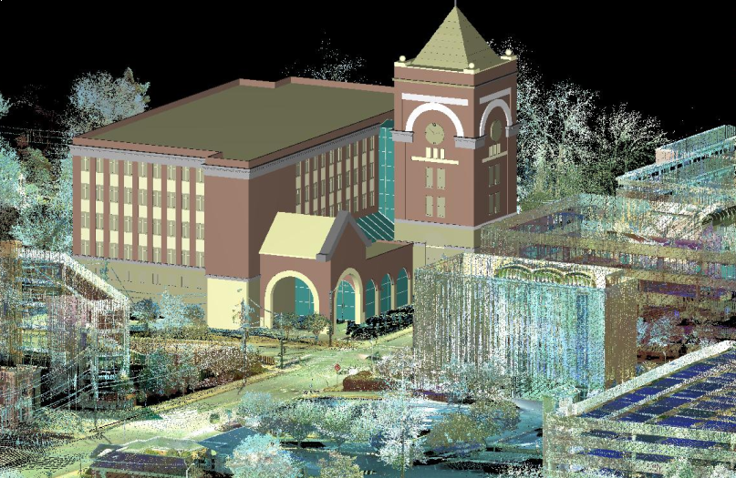
Augmented Reality (AR) is a live view of a real-world environment whose elements are augmented by computer generated sound, video, graphics or GPS data. If you consider that most new construction will first be built by engineers and designers in 3D in computers, then you may see where we are going with this.

With the base designed in 3D, you can then place a “target” in a construction zone. A target for augmented reality can really be anything as long as a tablet or cell phone can recognized it as graphic signal to launch 3D BIM programs.

These targets are used to orient the tablet to the exact same design point as where the construction is occurring on the ground. When targets are scanned with a tablet, the original design for that exact spot of construction is displayed. As the tablet is moved around this area, you can view the construction in 3D at a specific location.

Here’s an excellent example: Assume that you have a three-sided, multi-story concrete opening for a proposed staircase. By scanning the target placed in that area, construction workers can see on their iPad or Android tablet exactly what the finished product will look like. Not just a flat drawing on 600 sheets of blue lines, but the 3D model of how it will actually fit into the opening.

And remember: the world is international and these projects are under construction all over the world. By doing this, we just transcended the language barrier. We just solved the problem of expert tradesmen who are great at their craft but may not read details on blueprints that well. We just got a crew of 2-5 construction workers from a point of unknown to a point where everyone has a perfect mental picture of what is going to be constructed. That’s a huge step!

One of the oldest sayings for any worthwhile project is, “Begin with the end in mind.” What a great way of accomplishing this.

As a testimony to how well this is working, many construction companies have been rolling out flat screen computers onsite to show superintendents actual BIM models by sequence. All throughout the day, they are used over and over by the workers who are building bridges, buildings, and infrastructure around the world.

These rolling 3D models are helping to get projects constructed right the first time. They are preventing construction problems and saving big money. Very soon, I believe that all of this will be done with either special glasses or projection screens.

Currently, the only obstacle slowing the process is having a way to orient a 3D BIM model real time inside of a building. Outside, it can be done with GPS. But inside, it is more challenging.

However, augmented reality will very quickly make paper plans obsolete. I have seen it in too many places and have seen the benefits. It is coming and will soon be a standard. All of the major construction companies are embracing this technology.

Another real use of augmented reality will be in the operations of the finished building. The technology already exists to allow a maintenance worker to go up to a motor or valve (or any piece of equipment that has a target) and scan it with his tablet or phone.

This opens up a computer database so that he can see the last maintenance schedule and the internal parts of the machine. If he services the machine, his data is automatically sent to the company database and is available for anyone to review. Or, if a repair is needed, he can launch a video of how to take apart the machine and replace any part he needs.

This brings the power of the “owner’s manual” and the entire knowledge stored in the computers running the facility in real time 3D to the exact point it is needed. Imagine the implications if you own a complex manufacturing facility.

In just the past seven years, I have seen strides that were only imagined 10 years ago. But today, it’s all happening – and there are very creative people all over the country working on even more and more innovations. It’s an exciting industry to be working in!

###

Tate Jones has over 40 years of experience in land and aerial surveying and was one of the country’s earliest adopters of 3D laser scanning technology. A nationally recognized expert in the field of 3D data capture, he has worked with hundreds of clients in the engineering, architectural and construction industries. Contact him at tjones@lasurveying.com or visit www.landairsurveying.com.

An armed robbery, a high speed police chase and…laser scanning?

Sometimes I don’t have to look past the front page of the local newspaper to see a good example of laser scanning in action.

Tragically, there was a police-involved shooting in Cobb County, Georgia, this past weekend, as reported by the Atlanta Journal-Constitution. The suspect allegedly robbed a gas station and then led the police on a high speed chase. The chase ended on I-75 when the suspect pointed a weapon at the police officers and was shot dead.

This was a very unfortunate incident, but the impact on the community was far lessened due to the outstanding work of the Georgia Bureau of Investigation.

The shooting and subsequent chase left many cars wrecked and damaged and, ultimately, the interstate was forced to close temporarily. As you can imagine, this was not a calm situation.

The GBI dispatched their laser scanning team to the site to set-up and scan the area to document the evidence both known and unknown at the time. They also generated 3D photography to further document the area in its entirety.

Using this method, they not only saved time, but were also able to quickly collect the data that would be necessary if the case were to go to trial.

So why use laser scanning to document a scene like this?

First, consider the sheer size of the scene. In this case, the area of study was larger than a football field. Without scanning, investigators would have had to take multiple photographs and make measurements with total stations that shoot one point at a time or worse, measure with 100 foot-long measuring tapes.

This takes much more time, requires more people, and creates much more chance for errors. The errors could be wrong measurements or even missed objects.

When you combine the laser point cloud data with the photographic data, the measurements and the scene become much more intuitive and obvious. You can place the evidence markers by the evidence within the scene and the scanner automatically picks them up.

Instead of making and recording many different angles and distances, you simple put in the points per square foot you want to capture into the scanner and in about 15 minutes, you have a completed scan with photography.

You can look at the scan and very clearly see the markers and measure from any object in the scan to any other object in the scan. So, if you need to know how long a skid mark is, for example, you would just click two points – one at the beginning and one at the end – and the measurement would be instantly generated.

With laser scanning, time at the scene is used to locate and mark the evidence and important points in the scene. All critical measurements can be made offsite after the scene is moved and the traffic is moving again.

Here’s the most important part: If you need information about the scene, but did not know it at the time of the scan, all is not lost! If it exists in the scan, you can make all the measurements you need to document the new (previously unknown) evidence.

More and more, laser scanners are being used to document crime scenes across the country. District attorneys like the scanned data because they can easily view it.

Scanned data is totally objective in that it collects the whole scene. It is easy to put a point down on the ground every square inch so that the coverage of the site is complete. Additionally, the fact that no one has to decide what measurements are made in the field before they release traffic is very important.

Judges like the data because the jury does not have to visit the site to understand the scene. Instead, they can simply view it in 3D on a computer screen without leaving the courtroom.

Laser scanning also saves time and money. Traffic still has to be stopped for an investigation, but if not for laser scanners, it would be stopped longer and there would be less information collected.

###

Tate Jones has over 40 years of experience in land and aerial surveying and was one of the country’s earliest adopters of 3D laser scanning technology. A nationally recognized expert in the field of 3D data capture, he has worked with hundreds of clients in the engineering, architectural and construction industries. Contact him at tjones@lasurveying.com or visit www.landairsurveying.com.