
Just a few of our clients include the Department of Defense, the U.S. Fish and Wildlife Service, state and local Departments of Transportation, and many municipal entities. We understand the importance of developing and maintaining excellent relationships with our clients in these industries, and increasing our efficiency and quality though gathering experience with these types of projects – in the end it enables us to be cost effective and provide faster delivery of the finished product. A military base is often a microcosm of the outside world, with all the expected facilities necessary for daily life found in one compact location. LandAir has extensive experience in a wide variety of such facilities.
FSC Code: T014 Topography Services
PSC Code: R404 Land Surveys, Cadastral Services (Non-Construction)
NAICS: 541370 Surveying And Mapping (Except Geophysical) Services
CAGE Code: 329N0
DUNS: 140230454
Ft. Benning – Columbus, Georgia
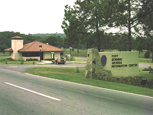 LandAir Surveying has done a variety of work for the Ft. Benning Army Base in the past several years. We recently performed a topographic survey of approximately 70 acres of property there known as the Martin Hospital. This survey included 1’ contour topography, as well as under- and above-ground utilities. All this data was tied to an overall aerial survey. The survey was referenced to the Georgia State Plane coordinate system.
In the past, we have performed fence staking from plans provided by the Army Corps of Engineers at approximately 100’ intervals or line of sight, a total linear footage of approximately 46,600’ of fence line. Approximately 29,000’ of property line needed to be established. We also performed guardrail staking for a total linear footage of 52,900’ of guardrail, and performed a topographic survey per the construction plans showing the new security roads to be constructed.
Additionally, for the Digital Multipurpose Range Complex, we staked the centerline for road construction along proposed trails every 50’ for approximately 8,500 linear feet at wetland areas that the trails cross along Sally Branch and Bonham Creek. We set construction limit stakes on a 15’ offset every 50’ along these proposed roads on both sides along the road corridors, totaling 17,000 linear feet. A 6-wheel ATV was utilized in wetland / swamp areas that were otherwise inaccessible by regular means.
Ft. Bliss Digital Multipurpose Range Complex – El Paso County, Texas
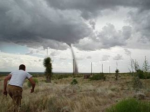 LandAir located and staked boring holes, and provided 100 spot checks of the existing topographic survey, for this Army base. Our work coincided with the appearance of a tornado quite nearby. Although the fort itself is located in Texas, much of their training facilities are in New Mexico, which is where we performed the work.