
LandAir Surveying provides a quality 3D imaging services program that has ready applications in telecommunications, with strong applications for telecom central office reengineering, design, and providing a 100% accurate verification of office records and inventory. 3D laser scanning provides an electronic image of the scanned target in millions of data points, and coherent logical grouping, yielding a 2D CADD drawing or 3D models with BIM compliant intelligent data.
LandAir provides the following services and deliverables applicable to telecom central offices:
- Interior and exterior 3D imaging services
- TruView is a 360 degree intelligent digital photo that captures all visual objects, including overhead racks, cable trays, power/communication cable runs, and demarcation areas. Objects can be marked up and measured from any point of reference. The measurements are reflected in both metric and standard notations. Also, any elevations can be marked and calculated automatically. Any area scanned with TruView and marked up can be sent via email or placed on the web for retrieval and easy collaboration.
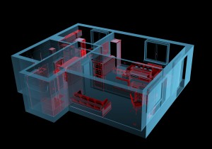
- Point clouds are millions of intelligent data points representing every detail oi the object scanned regardless of size. The accuracy of intelligent data points is 3/8 of an inch at 100 yards, and greater detail at closer distances and with different techniques. When grouped to define an object area, 2D drawings, with extremely accurate measurements, complete with elevations, can be generated in AutoCAD.
- Point cloud data is very important when renovating or expanding central office buildings or reconfiguring data areas. Before making changes, all data structures can be modeled in compliance with GSA’s BIM definition. When necessary, we can create animations to be added to a model. There are othei 3D applications that may become apparent as 3D imaging technology is applied to other processes.
- Both point cloud data and TruView data can be used together to increase accuracy of equipment inventory, which is important in capacity planning, as well as maintaining accurate tax depreciation schedules.
- The external building and internal shell can also be scanned to provide accurate engineering drawings on which to attach the building skin, as well as capturing existing infrastructure systems and equipment. 3D imaging and scanning data offers a potential major saving in direct labor and rework costs for equipment retrofits and building additions.
*Additional videos are available below the active video.
*Note that all videos are not the work of LandAir Surveying. Those noted with “by Others” are shown to present the wide range of other uses of this technology.