
LandAir has 20 years of experience managing aerial projects. We are very familiar with all the aspects of relating aerial data with ground data. We have many subcontractors with mapping capabilities that we frequently employ, and have a professional relationship going back eight years with our current team. Because our owner has 20 years managing aerial projects, we will pick and manage the best team for your project. We have relationships with contractors that can provide any type of mapping from LIDAR to LAMP to high accuracy digital terrain modeling.
I-20 LAMP Control – Georgia
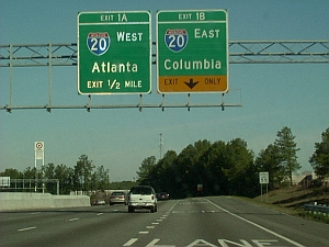 Utilizing a GPS network, LandAir established horizontal and vertical control points along I-20 on both sides of the interstate at two mile intervals. The project was begun at the eastbound exit ramp along I-20 at Turner Hill Road and proceeded east 33,200’ along I-20 to the end of the eastbound entrance ramp to I-20 at SR 138 (over 6.3 miles). We ran digital levels through the photo control targets, control point pairs and elevate the targets, and control points. We also set one set of LAMP photo control targets (two targets) at 500’ intervals, digitally scanned each bridge (five total) that crosses I-20 along these limits, and collected vertical clearances at each bridge.
King Mill Road – Henry County, Georgia
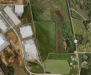 LandAir Surveying performed a boundary and aerial enhancement survey of approximately 450 acres of property. The topographic survey included right-of-way to-right-of-way locations along King Mill Road, Highway 23, and railroad right-of-way along the west side of the property (14 acres). A tree survey was performed and specimen trees located. We also located visible above-ground utilities, and located and detailed the creek on the south of the property (approximately 2,600’).