3D Laser Scanning gives law enforcement the upper hand in crime scene investigation and recreation
In October 2011, police responded to a grisly double-murder in Rocky Face, Georgia.
An elderly gentleman and a teenage girl were found dead from gunshot wounds to the head. The scene was even more revolting because the murderer had tried to cover his tracks by setting the house on fire.
What did the Georgia Bureau of Investigation use to document this complicated crime scene? They used 3D laser scanning. According to GBI Special Agent Jerry Scott, “It’s now the best technology available for documenting and recording crime scenes.”
Collecting evidence
3D Laser Scanning is quicker than other types of crime scene documentation and the technology provides much more useful data, making crime scene reconstruction more accurate, reliable, and easier to explain to a jury.
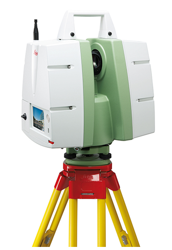
Police generally use the Leica C-10 as their scanner of choice. This instrument can take 84 pictures in about six minutes and measure from up to 200 feet away. With this capability, crime scene documentation can take up to 80% less time.
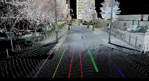
What does is record? Well, everything.
“Where the cars were, where the debris ended up, where the body was, where the weapon was – anything seen by the scanner, we will have,” said Sgt. Jeff Davis from the Arlington, Texas Police Department to WFAA in Dallas.
3D laser scanning is increasingly finding its home in other police forces across the country.
“It has become a standard part of our initial investigation process,” said Chattanooga Police Sgt. Darrell Whitfield, who was the first Chattanooga police investigator to train with the equipment.
Lieutenant Matt Magro of the Carlsbad, California Police Department told the news in San Diego, “It allows us to recreate the scene very quickly and very accurately. You can click on the bullet hole on the wall and then go to the shell casing and it will tell you what the distance between those objects is and the elevation in just the click of a mouse.”
During the investigation
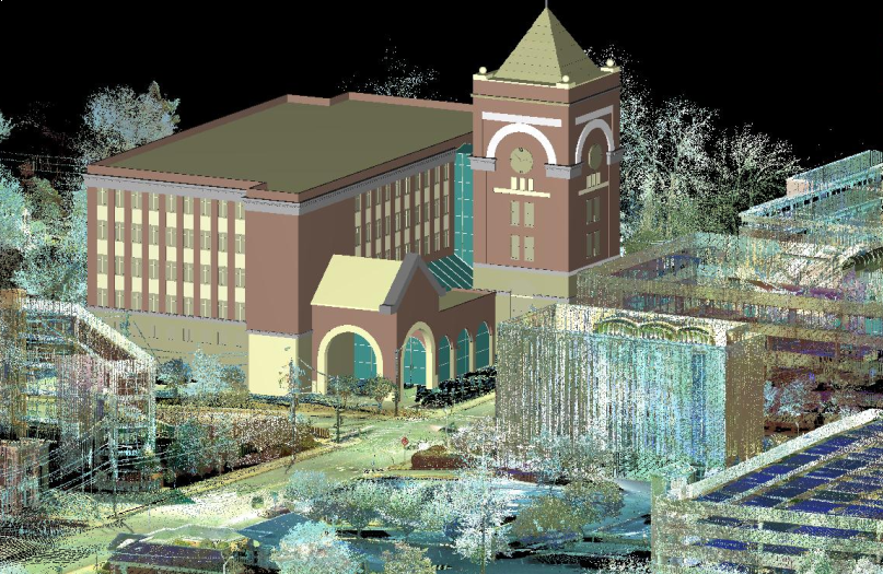
Once the site is cleaned up or altered in any way, the evidence is spoiled. However, 3D laser scanning allows investigators to return to the site at any time to retrieve missed or forgotten details. Investigators can view vivid color 3D data and extract any measurement they need long after the scene has been released.
At the crime scene, investigators take photographs, make measurements and sketches, and interview witnesses. However, even the most seasoned investigator can miss critical details due to time constraints, site access, or simple knowledge of the facts.
Sgt. Davis noted that having access to the scene as it was days, months, or even years after is extremely valuable. “If something comes up later, then we are able to go back to the scan and extract that information.”
As a case develops, investigators can use the 3D scan to determine which “witnesses” could really see what happened. When a gun is involved, for example, built-in shooting reconstruction tools can zero in on probable shooter locations.
Using the data at trial
3D laser scanning has also become a game-changer in court.
“It gives juries a virtual tour of the crime scene,” said Iredell County, North Carolina Sheriff’s Chief Deputy Rick Dowdle in the Moorsville Tribune.
Traditionally, the jury is shown a series of photographs and two dimensional diagrams of the scene. This requires a great deal of explanation and imagination on the part of the jury.
It is also an answer to what Hamilton County District Attorney Bill Cox calls the “‘CSI effect” among modern jurors, many of whom consume a steady diet of crime and courtroom dramas.
“People watch television and they expect a lot of high-tech video and audio evidence,” Cox said in a recent interview.
As noted by Lt. Warren Hamlin of the Knox County Tennessee Police Department in an interview related to a murder trial in Tennessee, “It’s almost like taking the jury right to the crime scene. We can show pictures all day long, but when you’ve got a panoramic view that shows exactly how it looked and where everything was, that’s a much better depiction than a photograph. So, if a guy says, ‘I was standing in that corner,’ you can create a viewpoint exactly where his head would be and look around the model and tell whether yes, he could see that, or, no, he’s lying.”
The truth is that law enforcement is developing a tool to cut its investigation time and dramatically improve its effectiveness both during the investigation and in court. Defense attorneys had better start catching up.
###
David Headrick has over 20 years of experience in the surveying, engineering and legal industries, both as a project manager for LandAir Surveying and as a lawyer in private practice. He has represented numerous land surveyors, designers, architects, contractors and other industry professionals throughout his career. Today, David serves as an executive and project manager for LandAir, focused on developing and managing the company’s 3D Laser Scanning department. Contact him at dheadrick@lasurveying.com.
Sources:
Double murder victims shot in the head before suspect set house on fire (located at http://www.wrcbtv.com/story/15499351/north-georgia-double-murder-victims-shot-in-the-head-before?clienttype=printable)
Georgia Bureau of Investigation agents train with 3-D laser scanners in Dalton (located at http://www.timesfreepress.com/news/2012/jan/22/crime-scene-science-gbi-agents-train-with-3-d/)
High-tech scanning system keeps record of scenes for Arlington PD (located at http://www.wfaa.com/news/crime/High-Tech-System–Scanning-Incidents-in-Arlington–171642511.html)
Laser scanning system enables CPD to reproduce 3D crime scene (http://www.timesfreepress.com/news/2011/nov/06/laser-scanning-system-enables-jurors-reproduce-3d-/)
Revolutionizing Crime Documenting Tool (located at http://www.sandiego6.com/news/local/Revolutionizing-Crime-Documenting-Tool-183033771.html)