Landair Surveying News

What’s all the fuss about high definition scanning?

When it comes to making precise measurements in complicated environments, high definition scanning – or 3D laser surveying, as it is sometimes called – is quickly making its way to the front of the line in a wide range of industries from engineering to historic preservation.

Engineers use laser scans to work with real-world conditions in complex industrial as-built and plant environments. Construction companies use them to gather precise data on site terrain and renovations, and architects use them to check proposed design models against existing conditions to fine-tune their designs.

Even insurance companies and law enforcement have gotten on board, utilizing the technology to recreate large-scale accident scenes.

Why is it better? For one, laser scans are incredibly precise. Images are created from a “point cloud” of millions of points that can be measured precisely including the distances and elevations between points. They are also versatile. The scans, when used with digital color photos, can produce survey-quality files, videos or even 3D animated computer models and are so intuitive that even a novice can understand the information.

Laser scans are also fast. In 2006, when we bought our first scanner, it took almost an hour to produce a full dome 360 degree scan. Now we can scan in 6-8 minutes. This allows us to take many more scans and capture more detail than we did before.

Scanning almost always pays for itself. It is cheaper in the long run because you can revisit the original scan multiple times from your computer desktop without having to revisit the project site. Also, because the technology is so precise, the need for construction reworks and expensive retrofitting is minimized or removed alltogether.

For firms thinking about getting involved with this technology, there are currently three ways to capture 3D data on large scale projects: Airborne LiDAR (Light Detection And Ranging), Mobile LiDAR, and Terrestrial Scanners, which all produce LiDAR data.

Typical projects for terrestrial scanners are large pipes and tunnels, manufacturing facilities, plant process facilities, airport conveyor systems, bridges, buildings, towers and construction projects. (Our firm focuses on terrestrial jobs, as most cannot be readily scanned from airplanes or cars.)

The cost of entry into this kind of scanning is generally between $150,000 to $250,000 for the first units and software. (Although less expensive scanners are now available, software packages can still be expensive and the cost of training should also be considered.)

Aerial platforms and Mobile Platforms start at $500,000 and go up to $5,000,000. These units are constantly being upgraded with newer and better digital sensors and data management enhancements. We currently work with service contractors on these types of jobs, which are typically focused on documenting civil infrastructure on a much larger scale than terrestrial scans.

Projects could include scanning 100 miles of road to prepare a pavement analysis, mapping 1,000 miles of rail line, or mapping the City of Atlanta and producing 3D models of all the buildings.

If the cost of these units seems intimidating, keep in mind that firms that have already invested in these technologies are often open to partnering opportunities with smaller firms.

Small scanning focuses on objects the size of a Volkswagen all the way down to the mechanical components inside of a watch. The applications in this field – commonly referred to as “reverse engineering” – include quality control of manufactured parts or data capture for a manufactured process. A typical project could be scanning an ornate stair rail so that an exact replica can be created from wood, metal or composite.

This scanning method is so precise that you could dissemble a toaster, rifle or carburetor, scan the parts, manufacture duplicates, and they would all work when re-assembled.

What can be scanned?

If it can be built, it can be scanned. There is virtually nothing built that cannot be duplicated and modeled with current scanning techniques.

In addition to the engineering, construction and manufacturing industries, this technology is also being used by insurance companies and law enforcement to reconstruct accident scenes – like when a highway bridge falls during rush-hour traffic or a multi-car pile-up – and even on Hollywood sets. There are companies that make their living scanning elaborate movie sets before and after they are constructed.

To give you an idea of the wide-ranging capabilities of this technology, in the last month, we have scanned a 120-foot pipe in Chicago, a 737 aircraft in Delaware, a luggage system in LaGuardia, and the interior of a peppermill in Virginia. This technology is everywhere!

###

Tate Jones has over 40 years of experience in land and aerial surveying and was one of the country’s earliest adopters of 3D laser scanning technology. A nationally recognized expert in the field of 3D data capture, he has worked with hundreds of clients in the engineering, architectural and construction industries. Contact him at tjones@3DLaserSurveys.com or visit www.3DLaserSurveys.com.

An eight-lane bridge falls into the Mississippi River during rush hour traffic? Yeah – we do that.

A few years ago, an entire span of a busy eight-lane interstate bridge broke apart and fell into the Mississippi River in Minneapolis during rush hour traffic. Cars, concrete, twisted metal and people went crashing into the water.

When the dust settled, 13 were dead and more than 145 injured.

The bridge was Minnesota’s fifth busiest, carrying 140,000 vehicles each day. Eventually, the NTSB cited a design flaw – plus additional weight on the bridge at the time of the collapse – as the likely cause. It was one of the country’s worst infrastructure accidents in history.

When most people think of “forensics,” images of CSI and police dusting for fingerprints immediately come to mind. But do you also think of accident reconstruction and lasers?

In 2007, at the time of the bridge collapse, our firm was one of the first to use 3D laser scanning technology. When we heard about the bridge, we made some calls to the local authorities and offered our scanning services. The response was very positive. (Because of the magnitude of the disaster, the FBI ended-up scanning the site.)

The advantage and need for laser scanning in a case like this is to preserve the scene exactly as it is. On that evening in Minneapolis, the scene was changing, literally, as the rescue was taking place.

Cars were being checked and retrieved, pieces of the bridge were being moved, and all of this was taking place in a river. The precision of high-definition laser scanning and the ability to stay out of the way of first responders and rescue teams was very important.

Once scanned, the data files and photos of the scene could be sent directly to forensic engineers, the Department of Transportation, structural experts, bridge experts and many other engineers and contractors to begin collaborating on the information and building 3D computer models and animation.

Reconstruction is a critical because understanding how the bridge landed could be an excellent predictor of how it originally fell, which could lead to the point of the initial failure and ultimate collapse.

Unfortunately, these types of structural accidents happen all of the time. Recently, there have been several events here in Atlanta where this 3D scanning technology was used or could have been used.

Remember the bus accident on I-75 at Northside Drive, also in 2007? Six were killed when the bus carrying the Bluffton University baseball team tumbled over the highway overpass and hit the ground 30 feet below. The scene was scanned to run a simulation of what might have happened. Investigators later determined that the driver mistook the exit ramp for a lane and went into the curve at full speed.

Or what about the collapse of the elevated pedestrian bridge at the Atlanta Botanical Gardens in 2008 that killed one and injured 18? This is another example of a site similar to the Minneapolis bridge collapse, but on a much smaller scale.

Another example was when a 170-foot section of the railing and fencing along Atlanta’s 17th Street Bridge came loose and crashed to the interstate below in 2011.

All of these are good examples of where 3D laser scanning technology was (or could have been) an excellent choice.

Tate Jones has over 40 years of experience in land and aerial surveying and was one of the country’s earliest adopters of 3D laser scanning technology. A nationally recognized expert in the field of 3D data capture, he has worked with hundreds of clients in the forensic engineering, law enforcement, criminal defense, architectural and construction industries. Contact him at tjones@3DForensicScans.com.

A 3D laser survey can save thousands – just ask America’s busiest airport.

When the time came to remove and renovate the existing underground baggage conveyor system in America’s busiest airport, the action never stopped.

The contractor hired for the renovation had a seemingly impossible task: build a new conveyor system while the old one was still in operation. No matter what, the luggage movers had to keep going.

Together, the contractor and a team of laser surveyors spent seven days scanning the site with high-speed scanners. They worked at night, when airport traffic was lightest, and when the final registered point cloud was compared to the proposed 3D model of the new conveyor system, critical clashes were detected.

By uncovering the interferences early, the contractor saved thousands in construction and re-manufacturing dollars.

Click here for the full case study.

High-definition scanning is changing the construction, architecture and engineering industries. The beauty of laser scanning is its ability to gather detailed data that the client doesn’t even know they need at the time, but will prove useful down the road.

In addition to being incredibly precise, scans can be used to produce point clouds, digital color photos, survey-quality files, computer models and videos from the scans of multiples views. You can insert animation or virtual buildings, roads and people to show proposed areas; or insert design drawings from BIM to check for clash or interference.

And once the site is scanned and processed, anyone – from analysts to engineers – can access it anytime. All you need to check and recheck engineering quality data is a desktop computer.

The cost savings of avoiding reconstruction and re-engineering far outweigh the cost of the scan itself. And, as with most things, isn’t it cheaper to get it right the first time?

###

Tate Jones has over 40 years of experience in land and aerial surveying and was one of the country’s earliest adopters of 3D laser scanning technology. A nationally recognized expert in the field of 3D data capture, he has worked with hundreds of clients in the engineering, architectural and construction industries. Contact him at tjones@3DLaserSurveys.com or visit www.3DLaserSurveys.com.
 

Surviving 2012: Six things every business can learn from the surveying industry

As a professional land surveyor for 40 years, I have a first-hand understanding of the housing downturn and subsequent economic recession we have been experiencing for the past six years.

At our firm, we began seeing the impact in early 2008, just one year after the peak in our business in 2007. Surveying is often viewed (at least by banks) as part of the construction industry and when construction loans dried-up, so did our business.

For surveyors, the hit was especially hard because our industry doesn’t just rely on the housing market, but also on commercial and retail expansion, which depends on the public sector to build infrastructure like new roads, sewer outfalls, parks, schools, airport expansions and industrial parks.

When things got bad, many surveyors began discounting their services in an attempt to hold onto their clients and market share. Over the past three years, for example, I have seen the fee and value of ALTA surveys – surveys required by banks before they will refinance a loan – sell for half of what they did before the fall.

The irony is that as the economy slowed, interest rates began to fall and investors, shopping centers and businesses began to refinance their properties. The need for ALTA surveys actually grew as a result! It was only a matter of months before attorneys representing banks began calling our firms asking for “ALTA updates,” implying something other than a new survey.

The firms of the future will be smaller with fewer permanent staff. Fees will change. It will no longer be just about how many crews you have, but how smart you are at collecting and selling 3D data. And those firms that can find ways to use existing sources of 3D data will be even better equipped to weather the storm.

For survey firms – as is true for all industries in this economy – the way to survive is to simply be a better businessperson. Here are six important things every business can learn from the surveying industry:

#1: Control your price. There are only two ways to control your prices: have a healthy backlog of profitable work and provide valuable services to your clients.

#2: Utilize subcontractors. Have a permanent staff large enough to process the workflow and provide quality control, but maintain relationships with good subcontractors and associate firms to expand your workforce when you have a wave a work that your permanent staff can’t handle.

#3: Make profit your goal – not billing. Just because you bill a crew out at $1,000 doesn’t mean you make $1,000. Your actual profits are typically closer to $150.

#4: Don’t buy – rent, swap and borrow. If you can rent a piece of equipment for $500 and make $150, you have greatly reduced your cash flow and improved your profit margin. Take a look at all of the expensive equipment you have purchased and must pay for every day. Unused equipment sitting on the shelf is not a good investment. Swap with other firms when you can, rent when you have to, and buy when the workload demands it.

#5: Always have a contract. Make the signing of a contract the starting point for every job. Even with an established client, having a signed contract can save a lot of scope creep and misunderstanding even on the simplest jobs.

#6: Don’t cut your price without changing the scope. Many lawyers have called to tell me that my price is too high. I remind them that it’s less than their price and they don’t even have to leave the office!

Lastly and most importantly, be realistic. If your workload goes down, you must cut your overhead immediately. For most of us, this means staff, which is always the hardest thing to do.

At one point, we had to reduce our employees from a high of 45 to just seven. We have since slowly built back up, but it was this reduction in staff, combined with tight cash management and a realistic outlook, that enabled us to survive.

The key to surviving this economy – for land surveying firms, as well as all business – is to be realistic, creative and adaptable. This is what it will take to survive and grow into better times.

###

Tate Jones has over 40 years of experience in land and aerial surveying and was one of the country’s earliest adopters of 3D laser scanning technology. A nationally recognized expert in the field of 3D data capture, he has worked with hundreds of clients in the engineering, architectural and construction industries. Contact him at tjones@3DLaserSurveys.com.

3D Laser Surveying – How it Works – Better. Faster. Cheaper.

3D laser surveying, or high-definition scanning, is quickly becoming the new industry standard when it comes to making precise measurements in complex environments.

Construction companies use laser scans to gather precise data on site terrain, renovations and additions. Architects use them to check proposed design models against existing conditions to fine-tune their designs, and engineers use 3D scans to work with real-world conditions in complex industrial as-built and plant environments.

The scans are quick, accurate and highly detailed and the result is big savings of both time and money by eliminating costly return visits to the project site and reducing the need for expensive reworks.

So, what exactly is this technology and how does it work?

How 3D Laser Scanning works. 3D laser scanning uses high speed lasers that fire at incredibly high rates of speed. The image is created from a “point cloud,” which contains millions of points that can be measured precisely including the distances and elevations between points.

AutoCAD drawings and 3D computer models are produced from the scanned data, enabling engineers, architects and designers access to 360° interactive high resolution images from any desktop computer.

Better. 3D laser scans are incredibly precise. The scans can be used to produce point clouds, digital color photos, survey-quality files, or computer models of objects, roads, bridges and buildings. You can also produce videos from the scans of multiples views; insert animation or virtual buildings, roads and people to show proposed areas; or insert design drawings from BIM to check for clash or interference.

Faster. 3D laser scans are fast. Depending on the scanner needed, it typically takes between five minutes to 30 minutes for a high resolution scan.

Cheaper. The cost of a high-resolution scan ultimately depends on the size and overall complexity of the project. On very simple projects, a traditional survey is typically less expensive. But for complex projects – such as a major intersection crossing in a high commercial area – a 3D scan is cheaper in the long run.

Because you can revisit the original scan multiple times from your computer desktop, costly return visits to the project site are eliminated. The precision of the scan also eliminates the need for construction reworks and expensive retrofitting. Sometimes the cost savings resulting from a 3D scan exceeds the cost of the scan itself by 300%.

###

Tate Jones has over 40 years of experience in land and aerial surveying and was one of the country’s earliest adopters of 3D laser scanning technology. A nationally recognized expert in the field of 3D data capture, he has worked with hundreds of clients in the engineering, architectural and construction industries. Contact him at tjones@3DLaserSurveys.com or visit www.3DLaserSurveys.com.
So I have a 3D Laser Scanner – now what?

There is a common misconception that 3D laser scanning is a one-size-fits-all solution for every project. The truth is, this new technology is powerful – but it’s not for every surveying firm and it’s not a fit for every project.

First, surveying with a scanner is not the same as with a total station or GPS. For one, there are no field notes – just lots of data points and photographic files.

Another important distinction is the line of site requirement. When a survey crew sets up a survey instrument, they are typically looking for a line of site to the next point. That’s not the case with a scanner, which requires a more focused coverage. Some setups may only be 15 feet from the last if you need to get more views of a complicated structure.

With laser scanning, it is common to gather data that the client does not need at the time, but may need to use later. Once a site is scanned and post-processed, engineers and analysts can check and re-check engineering quality data on a desktop computer any time.

Computer power plays a significant role in successful laser scanning. The post-processing of laser scanned data is critical and can be tedious on older computers. Before buying into scanning technology, invest in at least 64-bit machines with fast graphics cards and as much RAM memory as possible.

You may want one computer to process the scan data and another to process the photographic data. Laser scanners create enormous files that must be managed carefully in a consistent workflow. (Our exterior projects normally have 1 to 10 gigabytes of data and a major industrial facility can have over 150 gigabytes of data.) Create to processes and work flows to store and back up everything.

Finally, don’t expect clients to beat down your door, demanding a 3D laser scan. Buying a scanner won’t make jobs magically appear. The market is just learning about this technology and though it is well worth the investment for those firms willing to do the legwork to find the clients who want and need its special capabilities, you will have to do a lot of educating and demonstrations of what the world of 3D can bring to clients.

The key is listening to your clients and understanding their needs. Keep in mind that many potential clients don’t know what questions to ask. Until laser scanning becomes as common as GPS, surveyors will have to educate owners, architects, engineers and contractors about the benefits.

###

Tate Jones has over 40 years of experience in land and aerial surveying and was one of the country’s earliest adopters of 3D laser scanning technology. A nationally recognized expert in the field of 3D data capture, he has worked with hundreds of clients in the engineering, architectural and construction industries. Contact him at tjones@lasurveying.com. To learn more about 3D laser surveys, visit www.3DLaserSurveys.com.

Tripod Mounted or Mobile 3D Laser Scanning: Which is the right one for the job?

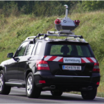
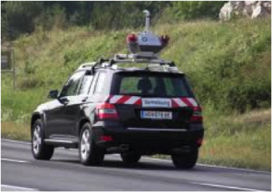
Riegl Scanner Mounted On Automobile

Riegl Scanner Mounted On Automobile

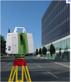
Leica C10 Terrestrial Scanner

Leica C10 Terrestrial Scanner

Having worked many years with terrestrial lidar platforms, I have had the unique experience of watching the industry grow and expand.  I have attended Leica conferences and Spar conferences in Texas and California every year since 2005 and I have been very impressed with seeing the innovations in 3D Laser data collection platforms. In this article I have purposely decided not to discuss the airborne platforms of fixed wing and helicopter, I will save that for another time. I have spent a lot of time with the tripod based Leica Scanning systems of the last 6 years.  At the same time, at the Spar conference and other equipment shows I also studied the Trimble, Faro and Riegl products as well as others that are excellent systems.  The point of this article is to compare the conditions and cost analysis of using a fixed tripod base 3D Laser Scanning system compared to a mobile truck or automobile mounted system for scanning road way corridors in database preparation for Federal, State, and County transportation projects.

General Project Specifications

While specs change from state to state these are the key factors:  Typically the engineer will request a corridor that is 200’ wide, centered on the existing roadway.  Sometimes it is wider and sometimes narrower.  The spec for vertical accuracy is normally about .10 foot or less accuracy on “hard” pavement and concrete surfaces including the paved shoulder.  All other surfaces in the corridor have to be within 6” vertical accuracy including bare ground, grass, overgrowth and thick vegetation.  Horizontal accuracy is standard second order.  Within the corridor you are expected to pick up all man made features- water valves, power poles, fire hydrants, pavement striping etc. In addition to this, the specifications you are required to have are a second order control point every 3000’ (sometimes closer), and a project control point every 1000’.  So this is the scope we are working toward for comparison of the two 3D Systems.

Comparison and Capabilities

The first thing to remember is that Laser Scanning is very precise on hard surfaces like pavement, houses, and power poles and not very good in vegetation.  I know that many software packages are offering “ bare ground” programs and in a commercial areas, with sparse vegetation that may be relevant but the test we have run using Lidar in foliage showed that the results consistently did not meet the spec of 6” vertical accuracy of the true ground when compared to standard 2nd order topographic survey methods.  So the value of the laser is on the pavement not with the foliage with either system.

The second consideration is that the cost of a tripod mounted 3D laser scanning system is in the $100,000 range, with software, probably $120,000 and can go as high as  $180,000.  A good mobile system with an Inertial Measurement Unit, GPS, two precise laser scanners, video cameras and a mobile computer controller system that allows the data to be captured at 40 or 50 miles per hour can cost between $500,000 and $1,200,000. The best mobile systems are $2,000,000 or more.  This is one of the biggest differences in the systems. So the billable charge per day is more for the more expensive system.

Daily Production Rates

Both systems require fixed survey control points to achieve the most accuracy.  However the effort to put the control in place is the same for both systems.  So while that is a very important factor, it is not a determining factor on which system to use.  The production rate of the systems is vastly different. Using a tripod mounted system for scanning and a two man crew, you can scan 3000 to 4000 feet of high quality data per day depending on density and congestion.  Billing a scanning crew at $3000 per day for data collection and adding another $1000 per day for data registration and feature extraction the cost comes to about $4000 so say it is $1.00 per foot.

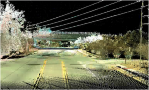
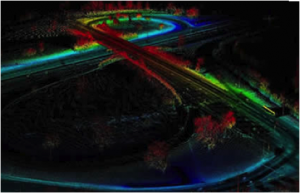
Example of Mobile Laser Scan Data

Example of Mobile Laser Scan Data

A mobile vehicle mounted system on the other hand can scan more than 50 miles of roadway per day. That is an enormous difference.   But this system  has the same limiting factors as the tripod system of being less effective in heavily congested areas. It is standard procedure on mobile scanning projects to run the travel lanes multiple times to get the best results.  So the production rate per day of the Mobile is 10 times (or more) greater than the tripod mounted system.

So on the face of it the mobile system sounds better, faster, and most efficient.  That is not always the case.  On real projects where we have compared systems to systems the cost for less than 10 miles of roadway is the same or a little less for the tripod mounted systems and the time frames is about the same for the completed deliverable.  Above 10 miles our experience has shown us that the mobile vehicle mounted system is probably more cost efficient.  Why? The mobilization cost of getting a Mobile system on site. Much like an aerial lidar job, sometimes the biggest cost is getting the aircraft over the site.  The same is true for mobile mapping.  The cost to get a mobile unite on your job can be $5000, or more, for the first mile.  The other factor is that it cost more to process the mobile data as you need to analyze and the various systems and make sure that the GPS and satellites are all working and collecting correctly.  Generally some type of test run is recommended.    I recently priced a job both ways and if you included all the variables 6 miles of road way came in at just under $30,000 and with mobile the cost was closer to $40,000 and I had some prices over $50,000.

There are still two other factors to consider.  As a surveyor I don’t get many transportation projects that are over 8 or 10 miles.  It is just that most projects, because of construction cost and size and cost generally stop at less than 10 miles.  There are exceptions, like long paving jobs that go 40 or 80 miles but they may or may not require highly detail surveys.

Bridge Interchange Project by LandAir Surveying

Bridge Interchange Project by LandAir Surveying

The other factor is speed.  If speed is important because of urgency to a project or danger there are many application where the data should be collected with a mobile unit.  Two examples;  First a 10,000’ runway project on a busy airport.  Normally the client will not allow you to close that type of runway for long periods of time for any reason. So for situations like this typically a mobile system is preferred.   Another example is a very complicated area where there is a necessity for a very fast turnaround of the data.  Some fast track projects require asbuilts data before the next phase of a project can be started.  In these cases mobile scanning has some advantages and the difference in cost maybe worth the savings in time.

Conclusion: Both systems can get good survey grade data if they are used by experienced technicians that understand what they need to be successful.  On actual projects I have priced, projects less than 8 or 10 miles are more cost effective with Tripod mounted systems and projects longer than this are faster and usually less expensive with the Vehicle mounted systems.  One last note! It is important to remember that collecting the hard pavement surfaces is only about 20% to 25% of a normal transportation job.


H. Tate Jones PLS

7.11.2011

SPAR 2011 Conference – Houston, Texas – Part 3

Revit 2012In part 1 of my review of SPAR 2011 I referred to the new and fascinating innovations in software over the past year.  I think probably the most important was the information from Autodesk that Revit 2012 will have a point cloud engine and many of the capabilities that other point cloud soft programs have and some new ones.  Revit has become the standard for BIM for the private sector and the Architectural world, so this was a very important release.  This will enable the Architectural community to be able to bring in and reference registered point clouds, and to benefit from the data-rich field that other software has been using. I have read many articles debating whether Architectural design firms wanted to be responsible for information contained within point clouds and there are good points on both sides of the room on this.  However this new release will allow them to compare their design to actual conditions within the point cloud (clash detection) and just this ability alone will lead to construction savings and fewer design revisions.  One of the new tools that was reviewed was their automatic feature extraction.  This is the beginning of a road that will lead to many great advances in the point cloud technology.  I saw this first in the mobile scanning programs.  In that example you could fence in a sign type like a merge sign on an interstate on ramp and tell the software to go find it and it would retrieve 80 to 95% of the similar signs in the cloud.  Inside the new Revit point cloud they are in the process ofSPAR International using similar technology to locate and capture elements that are already in the point cloud.  This will lead to very big productivity gains.  Just imagine if you could locate and detail all the windows in a building and have them sized and dimensioned automatically from just locating one and then having the software look for the remaining similar windows.

Revit BIM Modeling, does it increase efficiency in designing?  That has always been the big question.  I talked to several contractors who provided services creating BIM models and most said they could save as much as 30% of the cost from designing the old way with 2D paper drawings. The payback came by using the modeling through the complete project to save time on the construction details and other tedious time consuming task.  Again the more experienced designers got the biggest benefit.

Automated Pipe Modeling

ClearEdge 3DClearEdge3D has come through again.  In the automated modeling world they were one of the first to come out with a software that detected flat surfaces for Architectural and structural modeling.  They have again raised the bar with their new release of EdgeWise Plant.  They have designed a plant and pipe software that can analyze a point cloud and automatically detect and model about 50% of the pipes in a minimal amount of time.  Users were reporting that the time to model was approaching 1/3 the previous time on the same types of projects.  There is still work to be done for total automation but remember 3 years ago there was not a point cloud to model automatic software!  Now we are able to detect flat surfaces and pipe shapes.  All will be improved as time goes on but what a great leap.  I talk to some of my associates in the modeling business and they were looking at investing in the product.  This was the first year some of them had considered making the step up.
RealityLinx

RealityLinx is another program that specializes in the pipe industry and includes a pipe parts library and more importantly can export files into PDMS design software.  This software is used in the oil and gas industry as a standard design tool.  This software anticipates what parts the pipe are captured in the point cloud and saves a lot of trial and error in picking the right size bend etc.  Another software that we found interesting is 3D Reshaper.  Our firm purchased this software prior to the show and we found that it proves to be an excellent tool to complement the other software packages.  It is very good at cleaning noise in point clouds when using 3D laser scanning and creating smooth tin triangles so that surfaces can be smoothed efficiently.

These are real breakthroughs and will change the industry in a hurry. Just two weeks ago in one of my educational presentation I made the statement that “we were still in the model T ford days of point cloud software”.   I now feel like we are into the early 60’s model automobiles and heading full steam into the future models.  There was even talk of auto coding points in point clouds so that ceilings points knew they were ceilings and doors knew they were doors.  These programs are not there yet but they are on the way.  An interesting observation is that many of the small companies are driving the software innovation in addition to the traditional players like Autodesk.

Coolest Vendor I saw

XYZ RGBAt the end of the second day, I and a few other associates I have seen over the years went to the booth for XYZ RGB.  This stuff was so advanced that we had trouble understanding what made it work.  The technology uses a set of two digital cameras and an additional random dot projector and software and can capture an image and turn it into a point cloud of very fine mesh. He could even photograph objects using Apple IPHONES.  It is used in the movie, gaming and animation industries. It is excellent in small areas and does almost live animation of people. It can turn a photograph of a person into a model almost instantly. Very creative!  I am sure it has uses that have not been tried yet.

Spar 2011 was very beneficial and well worth the trip time and money.  Being in the 3D laser scanning industry, if I could only go to one show it would be SPAR.  There were more than 20 separate tracts to attend and they did a very thorough job of covering the industry.


H Tate Jones PLS


SPAR 2011 Conference – Houston, Texas – Part 2

The two main focuses of the SPAR 2011 conference are education and involvement with hardware products and software products which go along with and enable/enhance 3D Laser Scanning.  Generally I think that this year both of these advanced as much as I have seen since the early years in the industry.

Hardware-Terrestrial Scanners

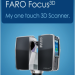
FARO Focus One Touch 3D Scanner

Where do you start with something so vast?  Probably the most talked about scanner was the new FARO Laser Scanner Focus 3D.  It is a phased base scanner.  Not only were they talked about but they received an award for the newest technological advancement.  FARO is a very good stable company and has been in the scanning and precision measurement business for many years but the model which list for between $40,000 and $45,000 will definitely find a place in the market.  At the same time Leica had its 7000 series and Z&F had their latest advancements in their technology displayed.  Presently I don’t think that you can compare the Faro scanner to the Z&F and Leica directly as they will likely fill different niches in the scanning world. The hardware advancements seem to be faster speeds and longer distances.  Many had better ways to overlay digital photography on top of the point cloud and auto target recognition.  Both of these problems are becoming more manageable with the latest technology.  The greatest difficulty of all the scanning products is still the large file sizes you get with an instrument that collects data at a rate of 2 million points a second.

Hardware-Mobile Scanners

Riegl Mobile Scanning SystemAll the major mobile scanner vehicles were on display in front of the conference center.  Topcon, Optech, Riegl, MDL, Trimble (indoor scanner) all had their version of the newest and most advanced Mobile scanners on some very good looking cars. I counted 9 different cars with scanner arrays.  Mounted on jeeps and Hummers and even the Mercedes Smart Car they were a very impressive presentation of mobile technology.  Through the advancements of better GPS, faster laser scanners, and methodology in the collection, most of the systems can achieve 1/10 of a foot accuracy on the pavement surface and hard surfaces and they scan at speeds approaching 50 miles per hour.  This enables them to collect data in areas that are dangerous for surveyors on foot or on surfaces that can only be mapped in constrained time frames like a 10,000 runway at and active major or military airport.  This technology has advanced so much it is becoming a very common way to collect data on existing roads and Interstates.  Most of the systems usually list in the range of $500,000 to $2,000,000 dollars.  It is definitely more cost effective to hire a good service provider on a project by project basis unless you are fully committed to providing the service.  These systems have the same common problems that all lidar systems have.  Foliage stills blocks the scanners from seeing the ground and GPS satellite blockage in Urban areas is a problem. Both can be solved but require field surveying to pick up additional data. I have several close associates that work with this technology and all say that they work better with survey target locations.  I have not ever heard any of them say that the systems could scan through dense foliage and find the true ground.  That is why I used the term “hard surfaces” in my description.  As more of these vehicles come on line, more and more road miles will be scanned.  I can see a time when mobile scanning could be done on a regular basis. One of the most common deliverables is to provide data for pavement analysis.

Underwater Scanners

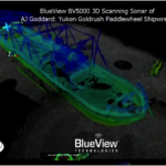
This is the first year I have seen technical seminars on underwater scanners.  Companies like BlueView Technologies, IXSEA, 2G Robotics, and DimEye put together a very informative presentation of the technology of underwater scanning.  Instead of Laser technology these submersible robots and high-tech mini-subs use sonar technology to scan underwater objects.  Some operate at 1000’s of feet deep in the ocean, and others operate in shallow water several hundred feet deep to 5 or 10 feet deep.   The data they collect can be used exactly the same way as laser scanned data and some can be modeled in the same software.

BlueView Technology Underwater ScanDeep water scanners mostly support the oil and gas industry while the shallow water scanners would be used for harbor engineering or locating and mapping submersed vessels.  This is a very fascinating new area that before was left to surface boats to collect.  Hydro dam inspection, pier and wharf inspection and many of the areas where the land structures around ports come into constant contact with the water can now be inspected and scanned underwater with reliable results and consistent data.

This technology of 3D digital data is certainly quickly changing the way we engineer the world we live in. (See our next section on new software innovation at SPAR 2011)


H. Tate Jones PLS


SPAR 2011 Conference – Houston, Texas – Part 1

SPAR InternationalI always look forward to the SPAR conference and this year was no exception.  SPAR 2011 was held last week in Houston, Texas.  For Surveyors, Engineers, Architects and lidar users and providers, this is the biggest show in America that features 3D Data capture of all kinds.  As President of LandAir Surveying, it is probably the most important conference that I attend each year. I have been attending the conference since 2005.   All of the various professionals in related industries attend and get to interact with all the Hardware and Software service providers who are there to show the “Great” improvements that have occurred over the past year.  I will say this year was exceptional in two areas.  First, automated point cloud modeling is coming along at a faster pace than even I expected.  More on this later.  The other notable improvement is how much photography is being used to supplement and even create 3D point clouds.  Overall this years conference was very impressive and showed how the technology is being embraced by more and more professionals and industries.

Overall Impressions

Autodesk ResearchFirst, this was the largest crowd ever to attend, as there were over 800 attendees from all the continents across the globe.  There were special pins given out to memorialize the recent events in Japan and the challenges that country faces.  The opening speaker Brian Matthews, with Autodesk Research laboratories was way over the top and was working on things and inventions so far ahead of where we currently are it was breath taking.  He showed great examples of how his group and others like them are pushing the envelope: from flying digital aerial photography with $100,000 drone unmanned helicopters, to showing us the improvements in 3D printing and how many companies are starting to use that technology, to create working models of machinery without outsourcing the prototype creation.

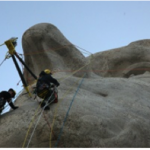
Mt Rushmore Climbing TeamAnother notable Speaker was Ruth Parsons the Executive Director of Historic Scotland.  Her group has an ambitious project to document the “Scottish Ten”.  The ten is a reference of their endeavor to document in full 3D the top 5 World Heritage sites in Scotland and the top 5 equivalent international sites around the world.   They are part of a group of non-profits that have taken on this task.  The Scottish team in conjunction with Cyark (founded by Ben Kycera one of the inventors of the Laser Scanner) work together to document Mt Rushmore and did quite an impressive job.  Expert climbers were used to strap 3D Laser scanners to the side of the mountain carved statues.  Ironically 3 of the 4 men carved on the mountain were Land Surveyors.  Several presentations have been made on the project which is really astonishing.

Scottish 10 Heritage SiteGenerally the conference was very successful in displaying and teaching the long strides this industry has made in the last decade.  New to the conference technology was the addition of underwater scanning presentation.  Few know or understand that it was underwater scanning that allowed the oil well in the Gulf of Mexico to be capped in the Summer of 2010.  I would tell anyone who is interested in 3D Laser scanning to attend this conference as every year it gets better and more complex.


H. Tate Jones PLS