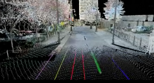
Much has been said about the advances in Laser Scanning technology but the transportation field is one of the environments that benefit the most from this technology.
Even with the introduction of mobile scanning which is done with lasers mounted on cars, terrestrial scanners, mounted on tripods, are still the most cost effective way to map the existing geometric and pavement conditions for the first 10 miles of any roadway. There are three benefits of scanning transportation corridors as opposed to traditional survey methods.
Complete Coverage
Laser scanners can collect data on a 1 foot grid which is 25 times the normal accuracy requirement for second order surveying. Or you can set the scanner to collect points at every 1” to capture very small details. With this type of data cross sections can be cut after the survey data is collected and they can be mapped not only on even 50’ intervals, but also at all critical stations, for example, the low point or crest of a hill. An even bigger advantage is that real visual computer simulations can be created to check site lines and obstructions and interferences. We have used this technology in automobile accident investigations.
Small Details
A big advantage of 3D laser scanning of transportation corridors is that when used correctly the coverage and detail is excellent. In very dense congested urban corridors all the physical above ground utilities are captured in the data. Objects like guy wires, overhead power lines, water valves, fire hydrants and road striping are easily captured. The sheer number of shots that are required to capture this information with traditional survey methods is almost unmanageable. A good survey crew working hard can only survey about 25% of the area in a day that a scanner can cover. On bridges and interchange surveys a scanner can capture all the data you need in minutes. The same coverage by a traditional survey crew would take days. With written survey notes you may need to revisit the site several times to check the quality of the information and check for missing objects. With Laser scanning you only need revisit the point cloud in the computer.

Safety
The greatest benefit for surveyors using 3D Laser Scanning to survey transportation is that it is so much safer. Having surveyors adjacent to traffic is the most dangerous place they can be. With a scanner they can survey the center lanes and walls without getting in harm’s way. This has already saved lives and will continue to save more.
Please enjoy some of the scans we have captured in our work on transportation corridors.
*Additional videos are available below the active video.

